Hanyuan Zhang
Can We Trust LLMs? Mitigate Overconfidence Bias in LLMs through Knowledge Transfer
May 27, 2024Abstract:The study explores mitigating overconfidence bias in LLMs to improve their reliability. We introduce a knowledge transfer (KT) method utilizing chain of thoughts, where "big" LLMs impart knowledge to "small" LLMs via detailed, sequential reasoning paths. This method uses advanced reasoning of larger models to fine-tune smaller models, enabling them to produce more accurate predictions with calibrated confidence. Experimental evaluation using multiple-choice questions and sentiment analysis across diverse datasets demonstrated the KT method's superiority over the vanilla and question-answer pair (QA) fine-tuning methods. The most significant improvement in three key metrics, where the KT method outperformed the vanilla and QA methods by an average of 55.3% and 43.1%, respectively. These findings underscore the KT method's potential in enhancing model trustworthiness and accuracy, offering precise outputs with well-matched confidence levels across various contexts.
YNetr: Dual-Encoder architecture on Plain Scan Liver Tumors
Mar 30, 2024
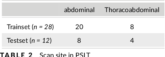

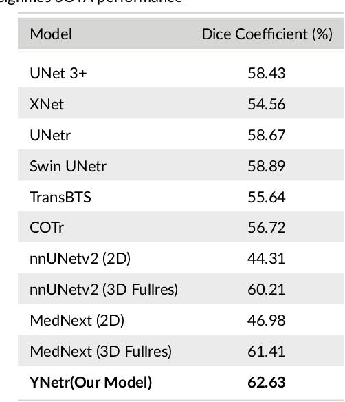
Abstract:Background: Liver tumors are abnormal growths in the liver that can be either benign or malignant, with liver cancer being a significant health concern worldwide. However, there is no dataset for plain scan segmentation of liver tumors, nor any related algorithms. To fill this gap, we propose Plain Scan Liver Tumors(PSLT) and YNetr. Methods: A collection of 40 liver tumor plain scan segmentation datasets was assembled and annotated. Concurrently, we utilized Dice coefficient as the metric for assessing the segmentation outcomes produced by YNetr, having advantage of capturing different frequency information. Results: The YNetr model achieved a Dice coefficient of 62.63% on the PSLT dataset, surpassing the other publicly available model by an accuracy margin of 1.22%. Comparative evaluations were conducted against a range of models including UNet 3+, XNet, UNetr, Swin UNetr, Trans-BTS, COTr, nnUNetv2 (2D), nnUNetv2 (3D fullres), MedNext (2D) and MedNext(3D fullres). Conclusions: We not only proposed a dataset named PSLT(Plain Scan Liver Tumors), but also explored a structure called YNetr that utilizes wavelet transform to extract different frequency information, which having the SOTA in PSLT by experiments.
RNTrajRec: Road Network Enhanced Trajectory Recovery with Spatial-Temporal Transformer
Nov 28, 2022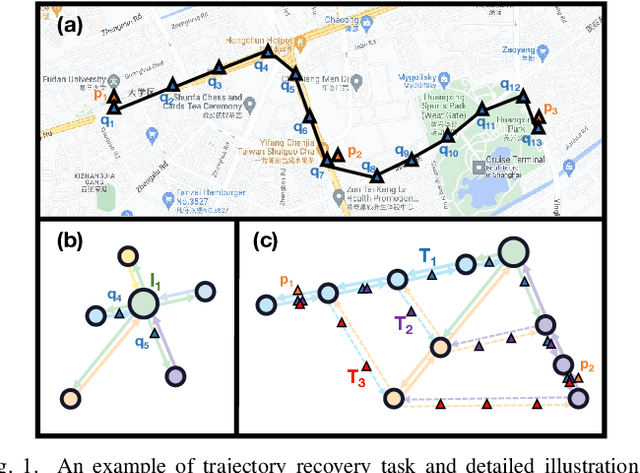
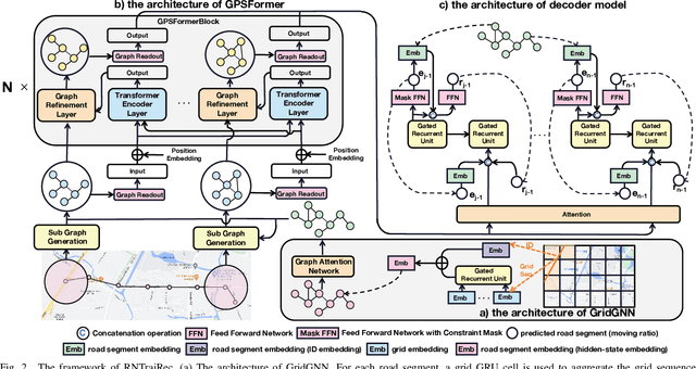
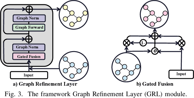
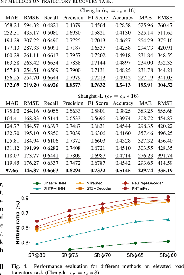
Abstract:GPS trajectories are the essential foundations for many trajectory-based applications, such as travel time estimation, traffic prediction and trajectory similarity measurement. Most applications require a large amount of high sample rate trajectories to achieve a good performance. However, many real-life trajectories are collected with low sample rate due to energy concern or other constraints.We study the task of trajectory recovery in this paper as a means for increasing the sample rate of low sample trajectories. Currently, most existing works on trajectory recovery follow a sequence-to-sequence diagram, with an encoder to encode a trajectory and a decoder to recover real GPS points in the trajectory. However, these works ignore the topology of road network and only use grid information or raw GPS points as input. Therefore, the encoder model is not able to capture rich spatial information of the GPS points along the trajectory, making the prediction less accurate and lack spatial consistency. In this paper, we propose a road network enhanced transformer-based framework, namely RNTrajRec, for trajectory recovery. RNTrajRec first uses a graph model, namely GridGNN, to learn the embedding features of each road segment. It next develops a spatial-temporal transformer model, namely GPSFormer, to learn rich spatial and temporal features along with a Sub-Graph Generation module to capture the spatial features for each GPS point in the trajectory. It finally forwards the outputs of encoder model into a multi-task decoder model to recover the missing GPS points. Extensive experiments based on three large-scale real-life trajectory datasets confirm the effectiveness of our approach.
DeepDualMapper: A Gated Fusion Network for Automatic Map Extraction using Aerial Images and Trajectories
Feb 17, 2020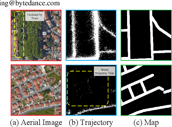
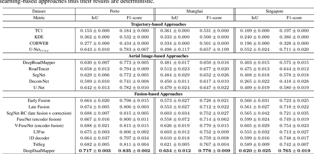

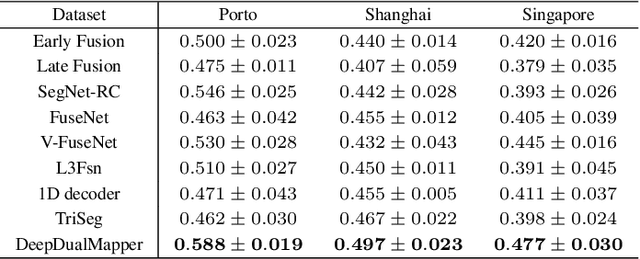
Abstract:Automatic map extraction is of great importance to urban computing and location-based services. Aerial image and GPS trajectory data refer to two different data sources that could be leveraged to generate the map, although they carry different types of information. Most previous works on data fusion between aerial images and data from auxiliary sensors do not fully utilize the information of both modalities and hence suffer from the issue of information loss. We propose a deep convolutional neural network called DeepDualMapper which fuses the aerial image and trajectory data in a more seamless manner to extract the digital map. We design a gated fusion module to explicitly control the information flows from both modalities in a complementary-aware manner. Moreover, we propose a novel densely supervised refinement decoder to generate the prediction in a coarse-to-fine way. Our comprehensive experiments demonstrate that DeepDualMapper can fuse the information of images and trajectories much more effectively than existing approaches, and is able to generate maps with higher accuracy.
DeepTravel: a Neural Network Based Travel Time Estimation Model with Auxiliary Supervision
Feb 06, 2018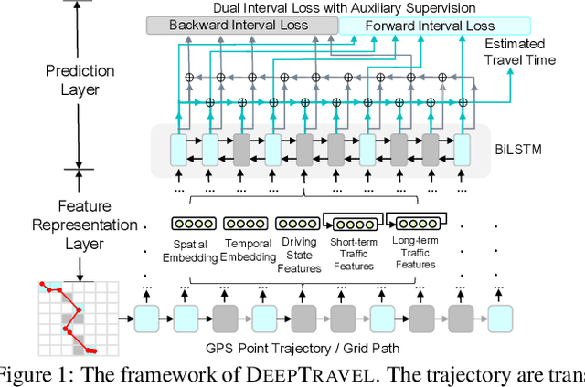
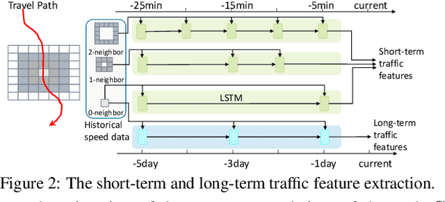

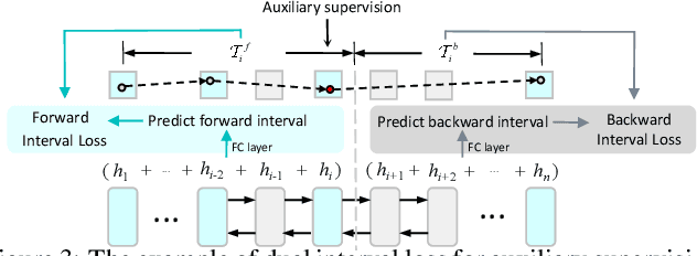
Abstract:Estimating the travel time of a path is of great importance to smart urban mobility. Existing approaches are either based on estimating the time cost of each road segment which are not able to capture many cross-segment complex factors, or designed heuristically in a non-learning-based way which fail to utilize the existing abundant temporal labels of the data, i.e., the time stamp of each trajectory point. In this paper, we leverage on new development of deep neural networks and propose a novel auxiliary supervision model, namely DeepTravel, that can automatically and effectively extract different features, as well as make full use of the temporal labels of the trajectory data. We have conducted comprehensive experiments on real datasets to demonstrate the out-performance of DeepTravel over existing approaches.
 Add to Chrome
 Add to Firefox
 Add to Edge