Zijin Wang
REACT: Runtime-Enabled Active Collision-avoidance Technique for Autonomous Driving
May 16, 2025Abstract:Achieving rapid and effective active collision avoidance in dynamic interactive traffic remains a core challenge for autonomous driving. This paper proposes REACT (Runtime-Enabled Active Collision-avoidance Technique), a closed-loop framework that integrates risk assessment with active avoidance control. By leveraging energy transfer principles and human-vehicle-road interaction modeling, REACT dynamically quantifies runtime risk and constructs a continuous spatial risk field. The system incorporates physically grounded safety constraints such as directional risk and traffic rules to identify high-risk zones and generate feasible, interpretable avoidance behaviors. A hierarchical warning trigger strategy and lightweight system design enhance runtime efficiency while ensuring real-time responsiveness. Evaluations across four representative high-risk scenarios including car-following braking, cut-in, rear-approaching, and intersection conflict demonstrate REACT's capability to accurately identify critical risks and execute proactive avoidance. Its risk estimation aligns closely with human driver cognition (i.e., warning lead time < 0.4 s), achieving 100% safe avoidance with zero false alarms or missed detections. Furthermore, it exhibits superior real-time performance (< 50 ms latency), strong foresight, and generalization. The lightweight architecture achieves state-of-the-art accuracy, highlighting its potential for real-time deployment in safety-critical autonomous systems.
RF-Enhanced Road Infrastructure for Intelligent Transportation
Nov 01, 2023


Abstract:The EPC GEN 2 communication protocol for Ultra-high frequency Radio Frequency Identification (RFID) has offered a promising avenue for advancing the intelligence of transportation infrastructure. With the capability of linking vehicles to RFID readers to crowdsource information from RFID tags on road infrastructures, the RF-enhanced road infrastructure (REI) can potentially transform data acquisition for urban transportation. Despite its potential, the broader adoption of RFID technologies in building intelligent roads has been limited by a deficiency in understanding how the GEN 2 protocol impacts system performance under different transportation settings. This paper fills this knowledge gap by presenting the system architecture and detailing the design challenges associated with REI. Comprehensive real-world experiments are conducted to assess REI's effectiveness across various urban contexts. The results yield crucial insights into the optimal design of on-vehicle RFID readers and on-road RFID tags, considering the constraints imposed by vehicle dynamics, road geometries, and tag placements. With the optimized designs of encoding schemes for reader-tag communication and on-vehicle antennas, REI is able to fulfill the requirements of traffic sign inventory management and environmental monitoring while falling short of catering to the demand for high-speed navigation. In particular, the Miller 2 encoding scheme strikes the best balance between reading performance (e.g., throughput) and noise tolerance for the multipath effect. Additionally, we show that the on-vehicle antenna should be oriented to maximize the available time for reading on-road tags, although it may reduce the received power by the tags in the forward link.
A Novel Temporal Multi-Gate Mixture-of-Experts Approach for Vehicle Trajectory and Driving Intention Prediction
Aug 01, 2023


Abstract:Accurate Vehicle Trajectory Prediction is critical for automated vehicles and advanced driver assistance systems. Vehicle trajectory prediction consists of two essential tasks, i.e., longitudinal position prediction and lateral position prediction. There is a significant correlation between driving intentions and vehicle motion. In existing work, the three tasks are often conducted separately without considering the relationships between the longitudinal position, lateral position, and driving intention. In this paper, we propose a novel Temporal Multi-Gate Mixture-of-Experts (TMMOE) model for simultaneously predicting the vehicle trajectory and driving intention. The proposed model consists of three layers: a shared layer, an expert layer, and a fully connected layer. In the model, the shared layer utilizes Temporal Convolutional Networks (TCN) to extract temporal features. Then the expert layer is built to identify different information according to the three tasks. Moreover, the fully connected layer is used to integrate and export prediction results. To achieve better performance, uncertainty algorithm is used to construct the multi-task loss function. Finally, the publicly available CitySim dataset validates the TMMOE model, demonstrating superior performance compared to the LSTM model, achieving the highest classification and regression results. Keywords: Vehicle trajectory prediction, driving intentions Classification, Multi-task
Advances and Applications of Computer Vision Techniques in Vehicle Trajectory Generation and Surrogate Traffic Safety Indicators
Mar 27, 2023
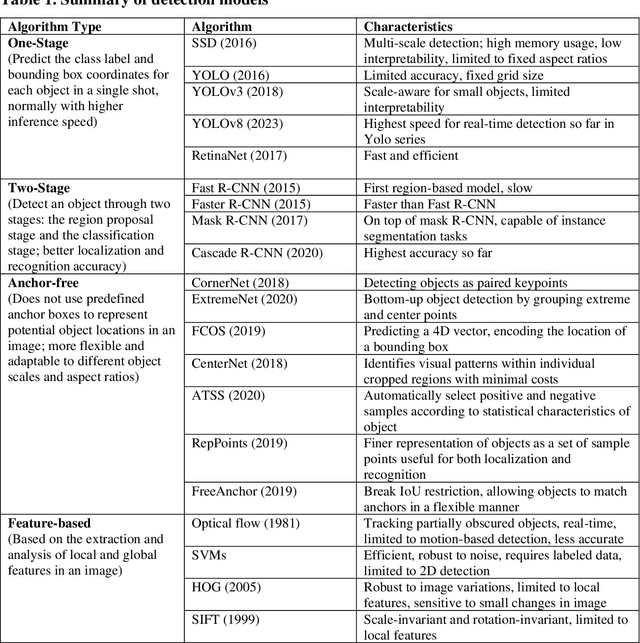
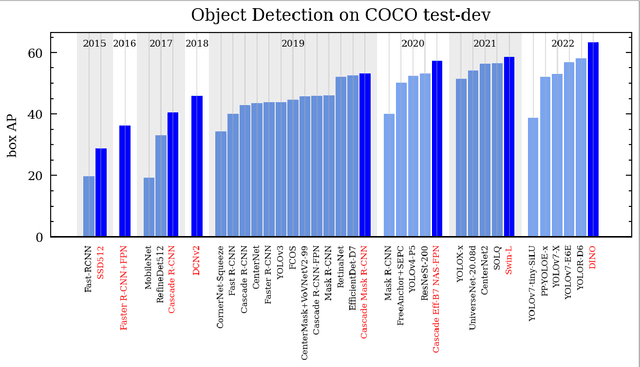
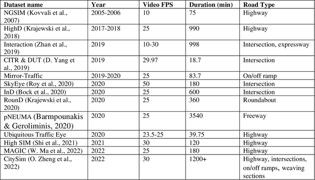
Abstract:The application of Computer Vision (CV) techniques massively stimulates microscopic traffic safety analysis from the perspective of traffic conflicts and near misses, which is usually measured using Surrogate Safety Measures (SSM). However, as video processing and traffic safety modeling are two separate research domains and few research have focused on systematically bridging the gap between them, it is necessary to provide transportation researchers and practitioners with corresponding guidance. With this aim in mind, this paper focuses on reviewing the applications of CV techniques in traffic safety modeling using SSM and suggesting the best way forward. The CV algorithm that are used for vehicle detection and tracking from early approaches to the state-of-the-art models are summarized at a high level. Then, the video pre-processing and post-processing techniques for vehicle trajectory extraction are introduced. A detailed review of SSMs for vehicle trajectory data along with their application on traffic safety analysis is presented. Finally, practical issues in traffic video processing and SSM-based safety analysis are discussed, and the available or potential solutions are provided. This review is expected to assist transportation researchers and engineers with the selection of suitable CV techniques for video processing, and the usage of SSMs for various traffic safety research objectives.
AVOID: Autonomous Vehicle Operation Incident Dataset Across the Globe
Mar 22, 2023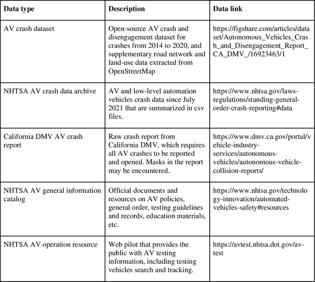
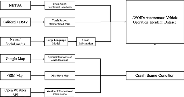
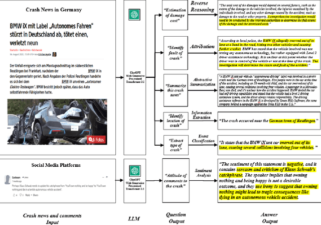
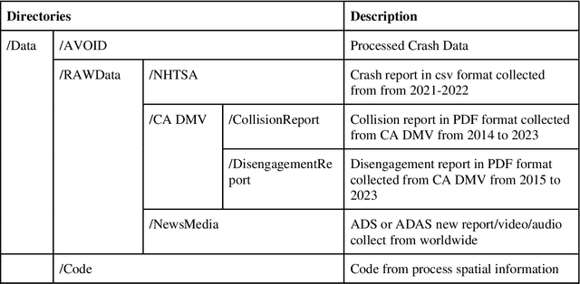
Abstract:Crash data of autonomous vehicles (AV) or vehicles equipped with advanced driver assistance systems (ADAS) are the key information to understand the crash nature and to enhance the automation systems. However, most of the existing crash data sources are either limited by the sample size or suffer from missing or unverified data. To contribute to the AV safety research community, we introduce AVOID: an open AV crash dataset. Three types of vehicles are considered: Advanced Driving System (ADS) vehicles, Advanced Driver Assistance Systems (ADAS) vehicles, and low-speed autonomous shuttles. The crash data are collected from the National Highway Traffic Safety Administration (NHTSA), California Department of Motor Vehicles (CA DMV) and incident news worldwide, and the data are manually verified and summarized in ready-to-use format. In addition, land use, weather, and geometry information are also provided. The dataset is expected to accelerate the research on AV crash analysis and potential risk identification by providing the research community with data of rich samples, diverse data sources, clear data structure, and high data quality.
ChatGPT Is on the Horizon: Could a Large Language Model Be All We Need for Intelligent Transportation?
Mar 21, 2023


Abstract:ChatGPT, developed by OpenAI, is one of the milestone large language models (LLMs) with 6 billion parameters. ChatGPT has demonstrated the impressive language understanding capability of LLM, particularly in generating conversational response. As LLMs start to gain more attention in various research or engineering domains, it is time to envision how LLM may revolutionize the way we approach intelligent transportation systems. This paper explores the future applications of LLM in addressing key transportation problems. By leveraging LLM with cross-modal encoder, an intelligent system can also process traffic data from different modalities and execute transportation operations through an LLM. We present and validate these potential transportation applications equipped by LLM. To further demonstrate this potential, we also provide a concrete smartphone-based crash report auto-generation and analysis framework as a use case. Despite the potential benefits, challenges related to data privacy, data quality, and model bias must be considered. Overall, the use of LLM in intelligent transport systems holds promise for more efficient, intelligent, and sustainable transportation systems that further improve daily life around the world.
Towards Next Generation of Pedestrian and Connected Vehicle In-the-loop Research: A Digital Twin Simulation Framework
Dec 08, 2022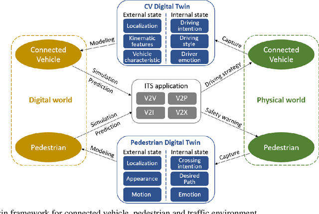
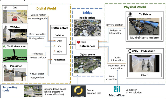
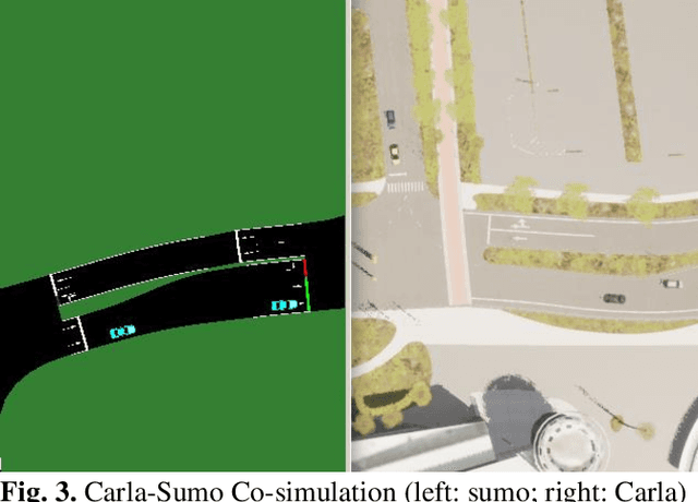
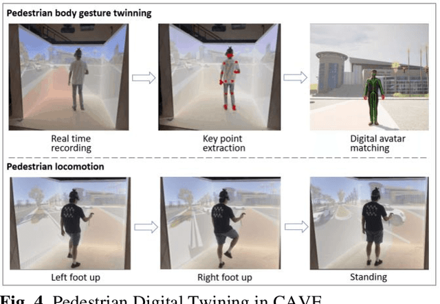
Abstract:Digital Twin is an emerging technology that replicates real-world entities into a digital space. It has attracted increasing attention in the transportation field and many researchers are exploring its future applications in the development of Intelligent Transportation System (ITS) technologies. Connected vehicles (CVs) and pedestrians are among the major traffic participants in ITS. However, the usage of Digital Twin in research involving both CV and pedestrian remains largely unexplored. In this study, a Digital Twin framework for CV and pedestrian in-the-loop simulation is proposed. The proposed framework consists of the physical world, the digital world, and data transmission in between. The features for the entities (CV and pedestrian) that need digital twined are divided into external state and internal state, and the attributes in each state are described. We also demonstrate a sample architecture under the proposed Digital Twin framework, which is based on Carla-Sumo Co-simulation and Cave automatic virtual environment (CAVE). The proposed framework is expected to provide guidance to the future Digital Twin research, and the architecture we build can serve as the testbed for further research and development of ITS applications on CV and pedestrian.
Trajectory Prediction for Vehicle Conflict Identification at Intersections Using Sequence-to-Sequence Recurrent Neural Networks
Oct 13, 2022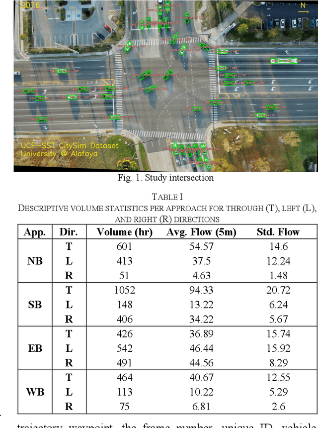
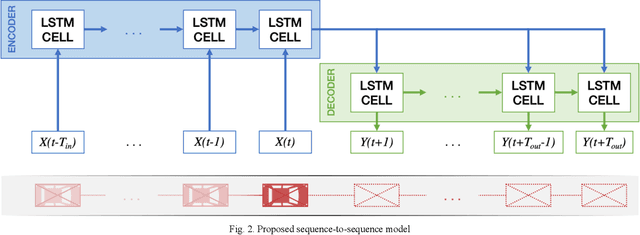
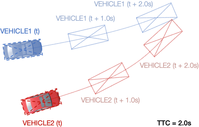
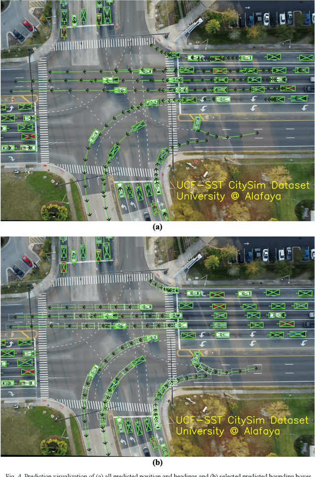
Abstract:Surrogate safety measures in the form of conflict indicators are indispensable components of the proactive traffic safety toolbox. Conflict indicators can be classified into past-trajectory-based conflicts and predicted-trajectory-based conflicts. While the calculation of the former class of conflicts is deterministic and unambiguous, the latter category is computed using predicted vehicle trajectories and is thus more stochastic. Consequently, the accuracy of prediction-based conflicts is contingent on the accuracy of the utilized trajectory prediction algorithm. Trajectory prediction can be a challenging task, particularly at intersections where vehicle maneuvers are diverse. Furthermore, due to limitations relating to the road user trajectory extraction pipelines, accurate geometric representation of vehicles during conflict analysis is a challenging task. Misrepresented geometries distort the real distances between vehicles under observation. In this research, a prediction-based conflict identification methodology was proposed. A sequence-to-sequence Recurrent Neural Network was developed to sequentially predict future vehicle trajectories for up to 3 seconds ahead. Furthermore, the proposed network was trained using the CitySim Dataset to forecast both future vehicle positions and headings to facilitate the prediction of future bounding boxes, thus maintaining accurate vehicle geometric representations. It was experimentally determined that the proposed method outperformed frequently used trajectory prediction models for conflict analysis at intersections. A comparison between Time-to-Collision (TTC) conflict identification using vehicle bounding boxes versus the commonly used vehicle center points for geometric representation was conducted. Compared to the bounding box method, the center point approach often failed to identify TTC conflicts or underestimated their severity.
CitySim: A Drone-Based Vehicle Trajectory Dataset for Safety Oriented Research and Digital Twins
Aug 23, 2022


Abstract:The development of safety-oriented research ideas and applications requires fine-grained vehicle trajectory data that not only has high accuracy but also captures a substantial number of critical safety events. This paper introduces the CitySim Dataset, which was devised with a core objective of facilitating safety-based research and applications. CitySim has vehicle trajectories extracted from 1140-minutes of drone videos recorded at 12 different locations. It covers a variety of road geometries including freeway basic segments, weaving segments, expressway merge/diverge segments, signalized intersections, stop-controlled intersections, and intersections without sign/signal control. CitySim trajectories were generated through a five-step procedure which ensured the trajectory accuracy. Furthermore, the dataset provides vehicle rotated bounding box information which is demonstrated to improve safety evaluation. Compared to other video-based trajectory datasets, the CitySim Dataset has significantly more critical safety events with higher severity including cut-in, merge, and diverge events. In addition, CitySim facilitates research towards digital twin applications by providing relevant assets like the recording locations'3D base maps and signal timings. These features enable more comprehensive conditions for safety research and applications such as autonomous vehicle safety and location-based safety analysis. The dataset is available online at https://github.com/ozheng1993/UCF-SST-CitySim-Dataset.
 Add to Chrome
 Add to Firefox
 Add to Edge