Zhiwei Xie
Massive Editing for Large Language Models Based on Dynamic Weight Generation
Dec 17, 2025Abstract:Knowledge Editing (KE) is a field that studies how to modify some knowledge in Large Language Models (LLMs) at a low cost (compared to pre-training). Currently, performing large-scale edits on LLMs while ensuring the Reliability, Generality, and Locality metrics of the edits remain a challenge. This paper proposes a Massive editing approach for LLMs based on dynamic weight Generation (MeG). Our MeG involves attaching a dynamic weight neuron to specific layers of the LLMs and using a diffusion model to conditionally generate the weights of this neuron based on the input query required for the knowledge. This allows the use of adding a single dynamic weight neuron to achieve the goal of large-scale knowledge editing. Experiments show that our MeG can significantly improve the performance of large-scale KE in terms of Reliability, Generality, and Locality metrics compared to existing knowledge editing methods, particularly with a high percentage point increase in the absolute value index for the Locality metric, demonstrating the advantages of our proposed method.
ReasoningV: Efficient Verilog Code Generation with Adaptive Hybrid Reasoning Model
Apr 20, 2025


Abstract:Large Language Models (LLMs) have advanced Verilog code generation significantly, yet face challenges in data quality, reasoning capabilities, and computational efficiency. This paper presents ReasoningV, a novel model employing a hybrid reasoning strategy that integrates trained intrinsic capabilities with dynamic inference adaptation for Verilog code generation. Our framework introduces three complementary innovations: (1) ReasoningV-5K, a high-quality dataset of 5,000 functionally verified instances with reasoning paths created through multi-dimensional filtering of PyraNet samples; (2) a two-stage training approach combining parameter-efficient fine-tuning for foundational knowledge with full-parameter optimization for enhanced reasoning; and (3) an adaptive reasoning mechanism that dynamically adjusts reasoning depth based on problem complexity, reducing token consumption by up to 75\% while preserving performance. Experimental results demonstrate ReasoningV's effectiveness with a pass@1 accuracy of 57.8\% on VerilogEval-human, achieving performance competitive with leading commercial models like Gemini-2.0-flash (59.5\%) and exceeding the previous best open-source model by 10.4 percentage points. ReasoningV offers a more reliable and accessible pathway for advancing AI-driven hardware design automation, with our model, data, and code available at https://github.com/BUAA-CLab/ReasoningV.
Multi-task deep learning for large-scale building detail extraction from high-resolution satellite imagery
Oct 29, 2023


Abstract:Understanding urban dynamics and promoting sustainable development requires comprehensive insights about buildings. While geospatial artificial intelligence has advanced the extraction of such details from Earth observational data, existing methods often suffer from computational inefficiencies and inconsistencies when compiling unified building-related datasets for practical applications. To bridge this gap, we introduce the Multi-task Building Refiner (MT-BR), an adaptable neural network tailored for simultaneous extraction of spatial and attributional building details from high-resolution satellite imagery, exemplified by building rooftops, urban functional types, and roof architectural types. Notably, MT-BR can be fine-tuned to incorporate additional building details, extending its applicability. For large-scale applications, we devise a novel spatial sampling scheme that strategically selects limited but representative image samples. This process optimizes both the spatial distribution of samples and the urban environmental characteristics they contain, thus enhancing extraction effectiveness while curtailing data preparation expenditures. We further enhance MT-BR's predictive performance and generalization capabilities through the integration of advanced augmentation techniques. Our quantitative results highlight the efficacy of the proposed methods. Specifically, networks trained with datasets curated via our sampling method demonstrate improved predictive accuracy relative to those using alternative sampling approaches, with no alterations to network architecture. Moreover, MT-BR consistently outperforms other state-of-the-art methods in extracting building details across various metrics. The real-world practicality is also demonstrated in an application across Shanghai, generating a unified dataset that encompasses both the spatial and attributional details of buildings.
Distribution Fitting for Combating Mode Collapse in GANs
Dec 03, 2022Abstract:Mode collapse is still a major unsolved problem in generative adversarial networks. In this work, we analyze the causes of mode collapse from a new perspective. Due to the nonuniform sampling in the training process, some sub-distributions can be missed while sampling data. Therefore, the GAN objective can reach the minimum when the generated distribution is not the same as the real one. To alleviate the problem, we propose a global distribution fitting (GDF) method by a penalty term to constrain generated data distribution. On the basis of not changing the global minimum of the GAN objective, GDF will make it harder to reach the minimum value when the generated distribution is not the same as the real one. Furthermore, we also propose a local distribution fitting (LDF) method to cope with the situation that the real distribution is unknown. Experiments on several benchmarks demonstrate the effectiveness and competitive performance of GDF and LDF.
Unified Chinese License Plate Detection and Recognition with High Efficiency
May 07, 2022


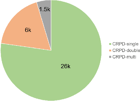
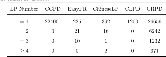
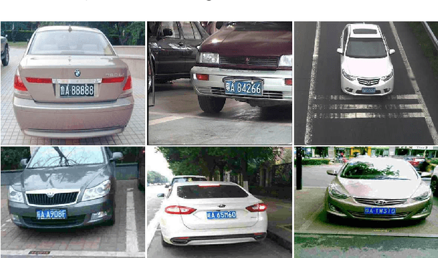
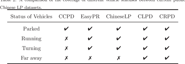
Abstract:Recently, deep learning-based methods have reached an excellent performance on License Plate (LP) detection and recognition tasks. However, it is still challenging to build a robust model for Chinese LPs since there are not enough large and representative datasets. In this work, we propose a new dataset named Chinese Road Plate Dataset (CRPD) that contains multi-objective Chinese LP images as a supplement to the existing public benchmarks. The images are mainly captured with electronic monitoring systems with detailed annotations. To our knowledge, CRPD is the largest public multi-objective Chinese LP dataset with annotations of vertices. With CRPD, a unified detection and recognition network with high efficiency is presented as the baseline. The network is end-to-end trainable with totally real-time inference efficiency (30 fps with 640p). The experiments on several public benchmarks demonstrate that our method has reached competitive performance. The code and dataset will be publicly available at https://github.com/yxgong0/CRPD.
 Add to Chrome
 Add to Firefox
 Add to Edge