Yotam Gigi
Google Research, Tel-Aviv, Israel
Flood forecasting with machine learning models in an operational framework
Nov 04, 2021


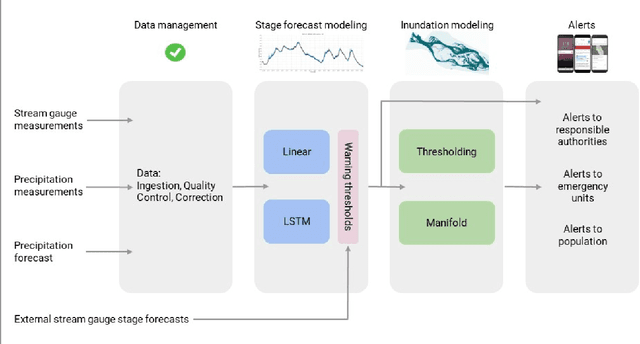
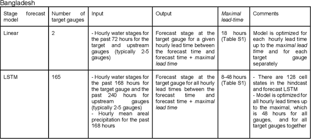
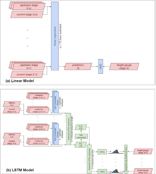
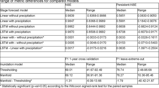
Abstract:The operational flood forecasting system by Google was developed to provide accurate real-time flood warnings to agencies and the public, with a focus on riverine floods in large, gauged rivers. It became operational in 2018 and has since expanded geographically. This forecasting system consists of four subsystems: data validation, stage forecasting, inundation modeling, and alert distribution. Machine learning is used for two of the subsystems. Stage forecasting is modeled with the Long Short-Term Memory (LSTM) networks and the Linear models. Flood inundation is computed with the Thresholding and the Manifold models, where the former computes inundation extent and the latter computes both inundation extent and depth. The Manifold model, presented here for the first time, provides a machine-learning alternative to hydraulic modeling of flood inundation. When evaluated on historical data, all models achieve sufficiently high-performance metrics for operational use. The LSTM showed higher skills than the Linear model, while the Thresholding and Manifold models achieved similar performance metrics for modeling inundation extent. During the 2021 monsoon season, the flood warning system was operational in India and Bangladesh, covering flood-prone regions around rivers with a total area of 287,000 km2, home to more than 350M people. More than 100M flood alerts were sent to affected populations, to relevant authorities, and to emergency organizations. Current and future work on the system includes extending coverage to additional flood-prone locations, as well as improving modeling capabilities and accuracy.
Spectral Algorithm for Low-rank Multitask Regression
Oct 27, 2019


Abstract:Multitask learning, i.e. taking advantage of the relatedness of individual tasks in order to improve performance on all of them, is a core challenge in the field of machine learning. We focus on matrix regression tasks where the rank of the weight matrix is constrained to reduce sample complexity. We introduce the common mechanism regression (CMR) model which assumes a shared left low-rank component across all tasks, but allows an individual per-task right low-rank component. This dramatically reduces the number of samples needed for accurate estimation. The problem of jointly recovering the common and the local components has a non-convex bi-linear structure. We overcome this hurdle and provide a provably beneficial non-iterative spectral algorithm. Appealingly, the solution has favorable behavior as a function of the number of related tasks and the small number of samples available for each one. We demonstrate the efficacy of our approach for the challenging task of remote river discharge estimation across multiple river sites, where data for each task is naturally scarce. In this scenario sharing a low-rank component between the tasks translates to a shared spectral reflection of the water, which is a true underlying physical model. We also show the benefit of the approach on the markedly different setting of image classification where the common component can be interpreted as the shared convolution filters.
ML for Flood Forecasting at Scale
Jan 28, 2019Abstract:Effective riverine flood forecasting at scale is hindered by a multitude of factors, most notably the need to rely on human calibration in current methodology, the limited amount of data for a specific location, and the computational difficulty of building continent/global level models that are sufficiently accurate. Machine learning (ML) is primed to be useful in this scenario: learned models often surpass human experts in complex high-dimensional scenarios, and the framework of transfer or multitask learning is an appealing solution for leveraging local signals to achieve improved global performance. We propose to build on these strengths and develop ML systems for timely and accurate riverine flood prediction.
Towards Global Remote Discharge Estimation: Using the Few to Estimate The Many
Jan 03, 2019
Abstract:Learning hydrologic models for accurate riverine flood prediction at scale is a challenge of great importance. One of the key difficulties is the need to rely on in-situ river discharge measurements, which can be quite scarce and unreliable, particularly in regions where floods cause the most damage every year. Accordingly, in this work we tackle the problem of river discharge estimation at different river locations. A core characteristic of the data at hand (e.g. satellite measurements) is that we have few measurements for many locations, all sharing the same physics that underlie the water discharge. We capture this scenario in a simple but powerful common mechanism regression (CMR) model with a local component as well as a shared one which captures the global discharge mechanism. The resulting learning objective is non-convex, but we show that we can find its global optimum by leveraging the power of joining local measurements across sites. In particular, using a spectral initialization with provable near-optimal accuracy, we can find the optimum using standard descent methods. We demonstrate the efficacy of our approach for the problem of discharge estimation using simulations.
 Add to Chrome
 Add to Firefox
 Add to Edge