Gideon Dror
Google Research, Tel-Aviv, Israel
Cross Modal Distillation for Flood Extent Mapping
Feb 16, 2023Abstract:The increasing intensity and frequency of floods is one of the many consequences of our changing climate. In this work, we explore ML techniques that improve the flood detection module of an operational early flood warning system. Our method exploits an unlabelled dataset of paired multi-spectral and Synthetic Aperture Radar (SAR) imagery to reduce the labeling requirements of a purely supervised learning method. Prior works have used unlabelled data by creating weak labels out of them. However, from our experiments we noticed that such a model still ends up learning the label mistakes in those weak labels. Motivated by knowledge distillation and semi supervised learning, we explore the use of a teacher to train a student with the help of a small hand labelled dataset and a large unlabelled dataset. Unlike the conventional self distillation setup, we propose a cross modal distillation framework that transfers supervision from a teacher trained on richer modality (multi-spectral images) to a student model trained on SAR imagery. The trained models are then tested on the Sen1Floods11 dataset. Our model outperforms the Sen1Floods11 baseline model trained on the weak labeled SAR imagery by an absolute margin of 6.53% Intersection-over-Union (IoU) on the test split.
Flood forecasting with machine learning models in an operational framework
Nov 04, 2021


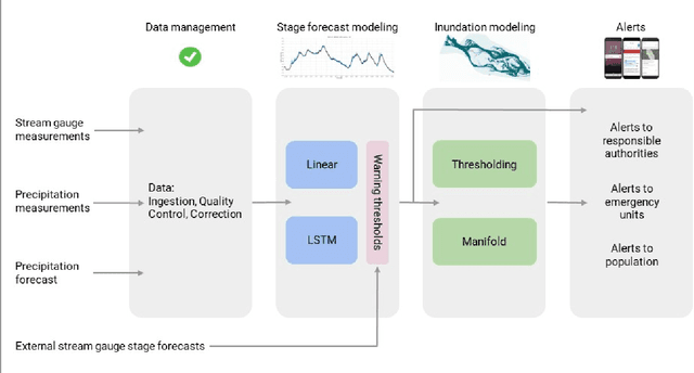
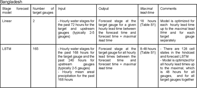
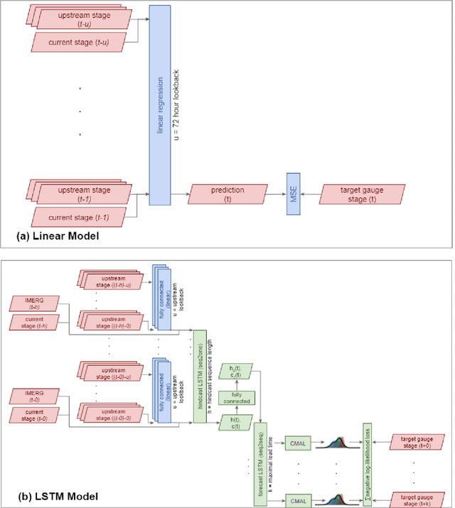
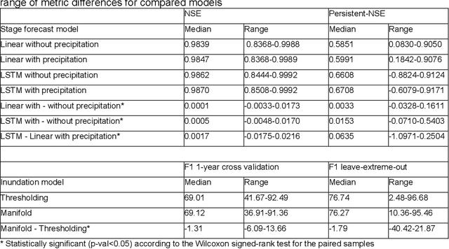
Abstract:The operational flood forecasting system by Google was developed to provide accurate real-time flood warnings to agencies and the public, with a focus on riverine floods in large, gauged rivers. It became operational in 2018 and has since expanded geographically. This forecasting system consists of four subsystems: data validation, stage forecasting, inundation modeling, and alert distribution. Machine learning is used for two of the subsystems. Stage forecasting is modeled with the Long Short-Term Memory (LSTM) networks and the Linear models. Flood inundation is computed with the Thresholding and the Manifold models, where the former computes inundation extent and the latter computes both inundation extent and depth. The Manifold model, presented here for the first time, provides a machine-learning alternative to hydraulic modeling of flood inundation. When evaluated on historical data, all models achieve sufficiently high-performance metrics for operational use. The LSTM showed higher skills than the Linear model, while the Thresholding and Manifold models achieved similar performance metrics for modeling inundation extent. During the 2021 monsoon season, the flood warning system was operational in India and Bangladesh, covering flood-prone regions around rivers with a total area of 287,000 km2, home to more than 350M people. More than 100M flood alerts were sent to affected populations, to relevant authorities, and to emergency organizations. Current and future work on the system includes extending coverage to additional flood-prone locations, as well as improving modeling capabilities and accuracy.
 Add to Chrome
 Add to Firefox
 Add to Edge