Vanessa Boehm
Deep learning based landslide density estimation on SAR data for rapid response
Nov 18, 2022Abstract:This work aims to produce landslide density estimates using Synthetic Aperture Radar (SAR) satellite imageries to prioritise emergency resources for rapid response. We use the United States Geological Survey (USGS) Landslide Inventory data annotated by experts after Hurricane Mar\'ia in Puerto Rico on Sept 20, 2017, and their subsequent susceptibility study which uses extensive additional information such as precipitation, soil moisture, geological terrain features, closeness to waterways and roads, etc. Since such data might not be available during other events or regions, we aimed to produce a landslide density map using only elevation and SAR data to be useful to decision-makers in rapid response scenarios. The USGS Landslide Inventory contains the coordinates of 71,431 landslide heads (not their full extent) and was obtained by manual inspection of aerial and satellite imagery. It is estimated that around 45\% of the landslides are smaller than a Sentinel-1 typical pixel which is 10m $\times$ 10m, although many are long and thin, probably leaving traces across several pixels. Our method obtains 0.814 AUC in predicting the correct density estimation class at the chip level (128$\times$128 pixels, at Sentinel-1 resolution) using only elevation data and up to three SAR acquisitions pre- and post-hurricane, thus enabling rapid assessment after a disaster. The USGS Susceptibility Study reports a 0.87 AUC, but it is measured at the landslide level and uses additional information sources (such as proximity to fluvial channels, roads, precipitation, etc.) which might not regularly be available in an rapid response emergency scenario.
Deep Learning for Rapid Landslide Detection using Synthetic Aperture Radar (SAR) Datacubes
Nov 05, 2022


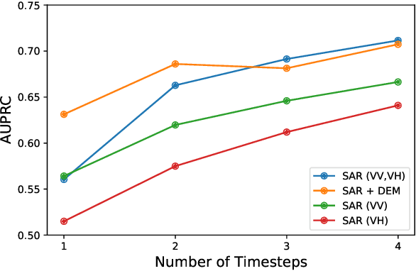
Abstract:With climate change predicted to increase the likelihood of landslide events, there is a growing need for rapid landslide detection technologies that help inform emergency responses. Synthetic Aperture Radar (SAR) is a remote sensing technique that can provide measurements of affected areas independent of weather or lighting conditions. Usage of SAR, however, is hindered by domain knowledge that is necessary for the pre-processing steps and its interpretation requires expert knowledge. We provide simplified, pre-processed, machine-learning ready SAR datacubes for four globally located landslide events obtained from several Sentinel-1 satellite passes before and after a landslide triggering event together with segmentation maps of the landslides. From this dataset, using the Hokkaido, Japan datacube, we study the feasibility of SAR-based landslide detection with supervised deep learning (DL). Our results demonstrate that DL models can be used to detect landslides from SAR data, achieving an Area under the Precision-Recall curve exceeding 0.7. We find that additional satellite visits enhance detection performance, but that early detection is possible when SAR data is combined with terrain information from a digital elevation model. This can be especially useful for time-critical emergency interventions. Code is made publicly available at https://github.com/iprapas/landslide-sar-unet.
Transformation Importance with Applications to Cosmology
Mar 04, 2020


Abstract:Machine learning lies at the heart of new possibilities for scientific discovery, knowledge generation, and artificial intelligence. Its potential benefits to these fields requires going beyond predictive accuracy and focusing on interpretability. In particular, many scientific problems require interpretations in a domain-specific interpretable feature space (e.g. the frequency domain) whereas attributions to the raw features (e.g. the pixel space) may be unintelligible or even misleading. To address this challenge, we propose TRIM (TRansformation IMportance), a novel approach which attributes importances to features in a transformed space and can be applied post-hoc to a fully trained model. TRIM is motivated by a cosmological parameter estimation problem using deep neural networks (DNNs) on simulated data, but it is generally applicable across domains/models and can be combined with any local interpretation method. In our cosmology example, combining TRIM with contextual decomposition shows promising results for identifying which frequencies a DNN uses, helping cosmologists to understand and validate that the model learns appropriate physical features rather than simulation artifacts.
Signal inference with unknown response: Calibration-uncertainty renormalized estimator
Mar 02, 2015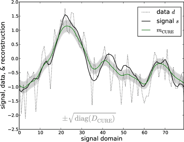
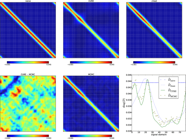
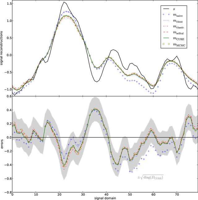
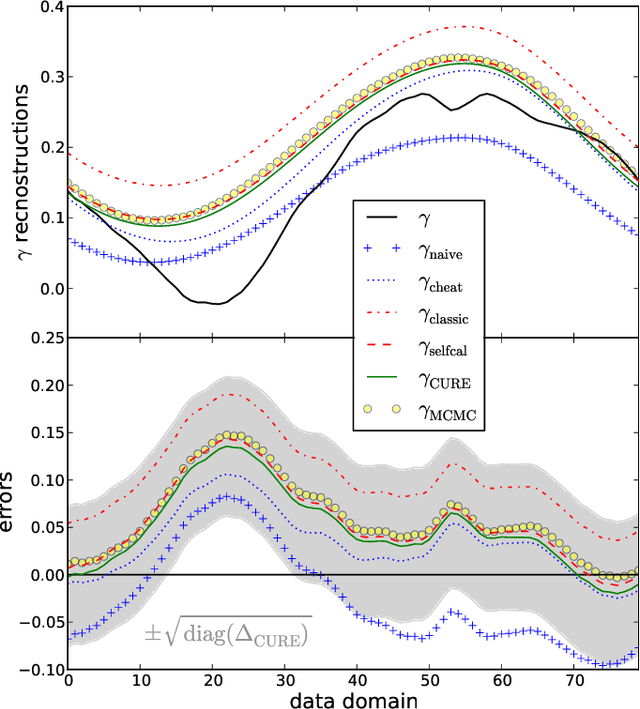
Abstract:The calibration of a measurement device is crucial for every scientific experiment, where a signal has to be inferred from data. We present CURE, the calibration uncertainty renormalized estimator, to reconstruct a signal and simultaneously the instrument's calibration from the same data without knowing the exact calibration, but its covariance structure. The idea of CURE, developed in the framework of information field theory, is starting with an assumed calibration to successively include more and more portions of calibration uncertainty into the signal inference equations and to absorb the resulting corrections into renormalized signal (and calibration) solutions. Thereby, the signal inference and calibration problem turns into solving a single system of ordinary differential equations and can be identified with common resummation techniques used in field theories. We verify CURE by applying it to a simplistic toy example and compare it against existent self-calibration schemes, Wiener filter solutions, and Markov Chain Monte Carlo sampling. We conclude that the method is able to keep up in accuracy with the best self-calibration methods and serves as a non-iterative alternative to it.
 Add to Chrome
 Add to Firefox
 Add to Edge