Ram Rajagopal
Stanford University
Towards Using Machine Learning to Generatively Simulate EV Charging in Urban Areas
Dec 13, 2024


Abstract:This study addresses the challenge of predicting electric vehicle (EV) charging profiles in urban locations with limited data. Utilizing a neural network architecture, we aim to uncover latent charging profiles influenced by spatio-temporal factors. Our model focuses on peak power demand and daily load shapes, providing insights into charging behavior. Our results indicate significant impacts from the type of Basic Administrative Units on predicted load curves, which contributes to the understanding and optimization of EV charging infrastructure in urban settings and allows Distribution System Operators (DSO) to more efficiently plan EV charging infrastructure expansion.
Designing forecasting software for forecast users: Empowering non-experts to create and understand their own forecasts
Apr 22, 2024


Abstract:Forecasts inform decision-making in nearly every domain. Forecasts are often produced by experts with rare or hard to acquire skills. In practice, forecasts are often used by domain experts and managers with little forecasting expertise. Our study focuses on how to design forecasting software that empowers non-expert users. We study how users can make use of state-of-the-art forecasting methods, embed their domain knowledge, and how they build understanding and trust towards generated forecasts. To do so, we co-designed a forecasting software prototype using feedback from users and then analyzed their interactions with our prototype. Our results identified three main considerations for non-expert users: (1) a safe stepwise approach facilitating causal understanding and trust; (2) a white box model supporting human-reasoning-friendly components; (3) the inclusion of domain knowledge. This paper contributes insights into how non-expert users interact with forecasting software and by recommending ways to design more accessible forecasting software.
* 10 pages
CityPulse: Fine-Grained Assessment of Urban Change with Street View Time Series
Jan 03, 2024Abstract:Urban transformations have profound societal impact on both individuals and communities at large. Accurately assessing these shifts is essential for understanding their underlying causes and ensuring sustainable urban planning. Traditional measurements often encounter constraints in spatial and temporal granularity, failing to capture real-time physical changes. While street view imagery, capturing the heartbeat of urban spaces from a pedestrian point of view, can add as a high-definition, up-to-date, and on-the-ground visual proxy of urban change. We curate the largest street view time series dataset to date, and propose an end-to-end change detection model to effectively capture physical alterations in the built environment at scale. We demonstrate the effectiveness of our proposed method by benchmark comparisons with previous literature and implementing it at the city-wide level. Our approach has the potential to supplement existing dataset and serve as a fine-grained and accurate assessment of urban change.
SkyScript: A Large and Semantically Diverse Vision-Language Dataset for Remote Sensing
Dec 20, 2023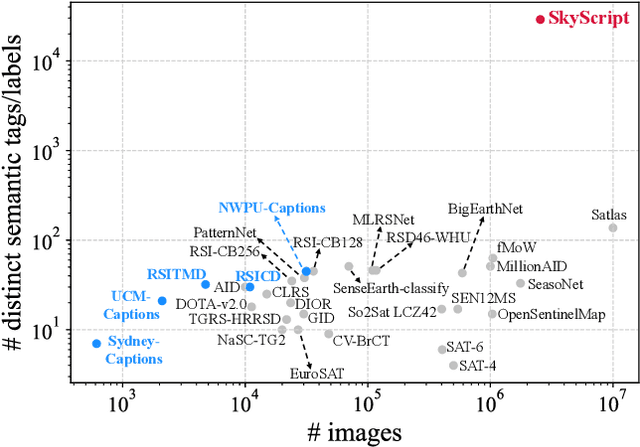
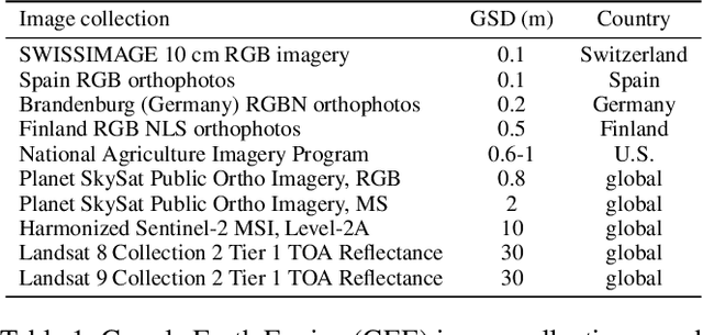
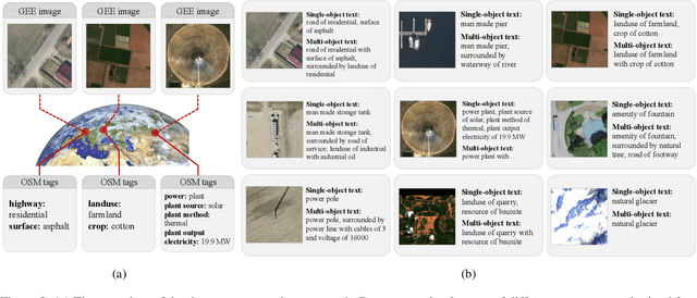

Abstract:Remote sensing imagery, despite its broad applications in helping achieve Sustainable Development Goals and tackle climate change, has not yet benefited from the recent advancements of versatile, task-agnostic vision language models (VLMs). A key reason is that the large-scale, semantically diverse image-text dataset required for developing VLMs is still absent for remote sensing images. Unlike natural images, remote sensing images and their associated text descriptions cannot be efficiently collected from the public Internet at scale. In this work, we bridge this gap by using geo-coordinates to automatically connect open, unlabeled remote sensing images with rich semantics covered in OpenStreetMap, and thus construct SkyScript, a comprehensive vision-language dataset for remote sensing images, comprising 2.6 million image-text pairs covering 29K distinct semantic tags. With continual pre-training on this dataset, we obtain a VLM that surpasses baseline models with a 6.2% average accuracy gain in zero-shot scene classification across seven benchmark datasets. It also demonstrates the ability of zero-shot transfer for fine-grained object attribute classification and cross-modal retrieval. We hope this dataset can support the advancement of VLMs for various multi-modal tasks in remote sensing, such as open-vocabulary classification, retrieval, captioning, and text-to-image synthesis.
TemperatureGAN: Generative Modeling of Regional Atmospheric Temperatures
Jun 29, 2023Abstract:Stochastic generators are useful for estimating climate impacts on various sectors. Projecting climate risk in various sectors, e.g. energy systems, requires generators that are accurate (statistical resemblance to ground-truth), reliable (do not produce erroneous examples), and efficient. Leveraging data from the North American Land Data Assimilation System, we introduce TemperatureGAN, a Generative Adversarial Network conditioned on months, locations, and time periods, to generate 2m above ground atmospheric temperatures at an hourly resolution. We propose evaluation methods and metrics to measure the quality of generated samples. We show that TemperatureGAN produces high-fidelity examples with good spatial representation and temporal dynamics consistent with known diurnal cycles.
Detecting Neighborhood Gentrification at Scale via Street-level Visual Data
Jan 04, 2023


Abstract:Neighborhood gentrification plays a significant role in shaping the social and economic well-being of both individuals and communities at large. While some efforts have been made to detect gentrification in cities, existing approaches rely mainly on estimated measures from survey data, require substantial work of human labeling, and are limited in characterizing the neighborhood as a whole. We propose a novel approach to detecting neighborhood gentrification at a large-scale based on the physical appearance of neighborhoods by incorporating historical street-level visual data. We show the effectiveness of the proposed method by comparing results from our approach with gentrification measures from previous literature and case studies. Our approach has the potential to supplement existing indicators of gentrification and become a valid resource for urban researchers and policy makers.
Constructing dynamic residential energy lifestyles using Latent Dirichlet Allocation
Apr 22, 2022
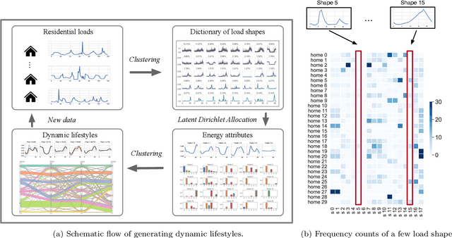
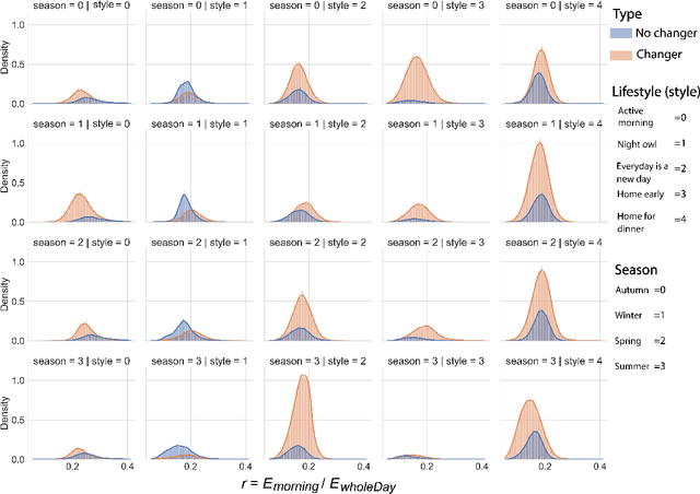
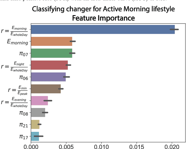
Abstract:The rapid expansion of Advanced Meter Infrastructure (AMI) has dramatically altered the energy information landscape. However, our ability to use this information to generate actionable insights about residential electricity demand remains limited. In this research, we propose and test a new framework for understanding residential electricity demand by using a dynamic energy lifestyles approach that is iterative and highly extensible. To obtain energy lifestyles, we develop a novel approach that applies Latent Dirichlet Allocation (LDA), a method commonly used for inferring the latent topical structure of text data, to extract a series of latent household energy attributes. By doing so, we provide a new perspective on household electricity consumption where each household is characterized by a mixture of energy attributes that form the building blocks for identifying a sparse collection of energy lifestyles. We examine this approach by running experiments on one year of hourly smart meter data from 60,000 households and we extract six energy attributes that describe general daily use patterns. We then use clustering techniques to derive six distinct energy lifestyle profiles from energy attribute proportions. Our lifestyle approach is also flexible to varying time interval lengths, and we test our lifestyle approach seasonally (Autumn, Winter, Spring, and Summer) to track energy lifestyle dynamics within and across households and find that around 73% of households manifest multiple lifestyles across a year. These energy lifestyles are then compared to different energy use characteristics, and we discuss their practical applications for demand response program design and lifestyle change analysis.
NeuralProphet: Explainable Forecasting at Scale
Nov 29, 2021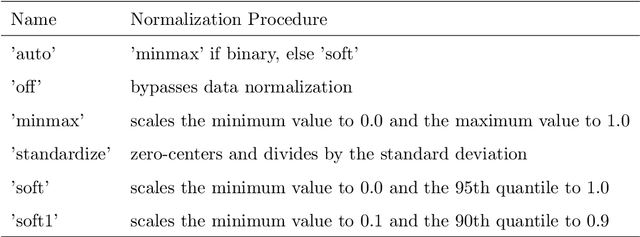

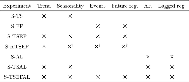
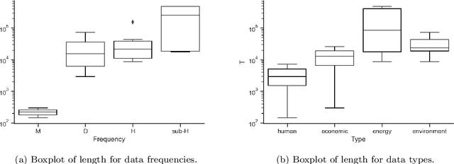
Abstract:We introduce NeuralProphet, a successor to Facebook Prophet, which set an industry standard for explainable, scalable, and user-friendly forecasting frameworks. With the proliferation of time series data, explainable forecasting remains a challenging task for business and operational decision making. Hybrid solutions are needed to bridge the gap between interpretable classical methods and scalable deep learning models. We view Prophet as a precursor to such a solution. However, Prophet lacks local context, which is essential for forecasting the near-term future and is challenging to extend due to its Stan backend. NeuralProphet is a hybrid forecasting framework based on PyTorch and trained with standard deep learning methods, making it easy for developers to extend the framework. Local context is introduced with auto-regression and covariate modules, which can be configured as classical linear regression or as Neural Networks. Otherwise, NeuralProphet retains the design philosophy of Prophet and provides the same basic model components. Our results demonstrate that NeuralProphet produces interpretable forecast components of equivalent or superior quality to Prophet on a set of generated time series. NeuralProphet outperforms Prophet on a diverse collection of real-world datasets. For short to medium-term forecasts, NeuralProphet improves forecast accuracy by 55 to 92 percent.
EVGen: Adversarial Networks for Learning Electric Vehicle Charging Loads and Hidden Representations
Aug 09, 2021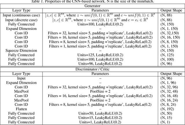
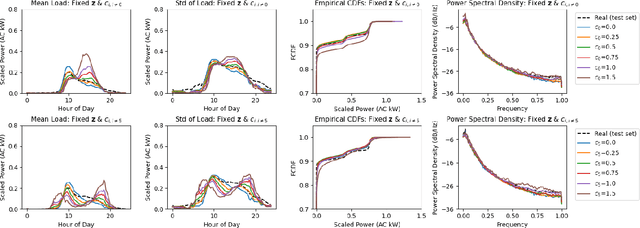
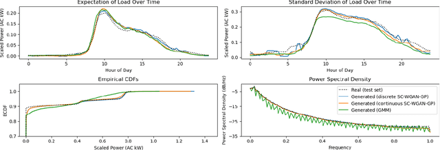
Abstract:The nexus between transportation, the power grid, and consumer behavior is more pronounced than ever before as the race to decarbonize the transportation sector intensifies. Electrification in the transportation sector has led to technology shifts and rapid deployment of electric vehicles (EVs). The potential increase in stochastic and spatially heterogeneous charging load presents a unique challenge that is not well studied, and will have significant impacts on grid operations, emissions, and system reliability if not managed effectively. Realistic scenario generators can help operators prepare, and machine learning can be leveraged to this end. In this work, we develop generative adversarial networks (GANs) to learn distributions of electric vehicle (EV) charging sessions and disentangled representations. We show that this model structure successfully parameterizes unlabeled temporal and power patterns without supervision and is able to generate synthetic data conditioned on these parameters. We benchmark the generation capability of this model with Gaussian Mixture Models (GMMs), and empirically show that our proposed model framework is better at capturing charging distributions and temporal dynamics.
Joint Optimization of Autonomous Electric Vehicle Fleet Operations and Charging Station Siting
Jul 21, 2021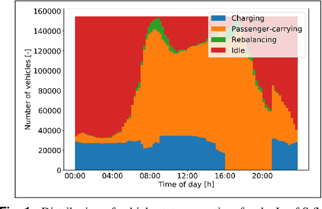
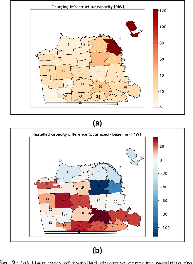
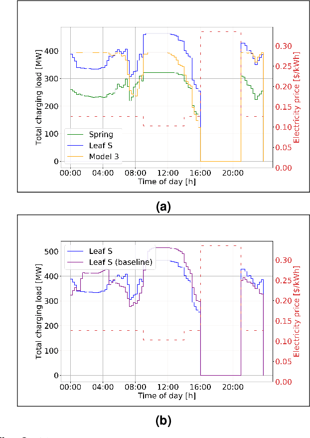
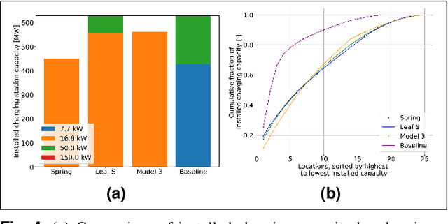
Abstract:Charging infrastructure is the coupling link between power and transportation networks, thus determining charging station siting is necessary for planning of power and transportation systems. While previous works have either optimized for charging station siting given historic travel behavior, or optimized fleet routing and charging given an assumed placement of the stations, this paper introduces a linear program that optimizes for station siting and macroscopic fleet operations in a joint fashion. Given an electricity retail rate and a set of travel demand requests, the optimization minimizes total cost for an autonomous EV fleet comprising of travel costs, station procurement costs, fleet procurement costs, and electricity costs, including demand charges. Specifically, the optimization returns the number of charging plugs for each charging rate (e.g., Level 2, DC fast charging) at each candidate location, as well as the optimal routing and charging of the fleet. From a case-study of an electric vehicle fleet operating in San Francisco, our results show that, albeit with range limitations, small EVs with low procurement costs and high energy efficiencies are the most cost-effective in terms of total ownership costs. Furthermore, the optimal siting of charging stations is more spatially distributed than the current siting of stations, consisting mainly of high-power Level 2 AC stations (16.8 kW) with a small share of DC fast charging stations and no standard 7.7kW Level 2 stations. Optimal siting reduces the total costs, empty vehicle travel, and peak charging load by up to 10%.
 Add to Chrome
 Add to Firefox
 Add to Edge