 Add to Chrome
 Add to Firefox
 Add to Edge
RayFronts: Open-Set Semantic Ray Frontiers for Online Scene Understanding and Exploration
Apr 09, 2025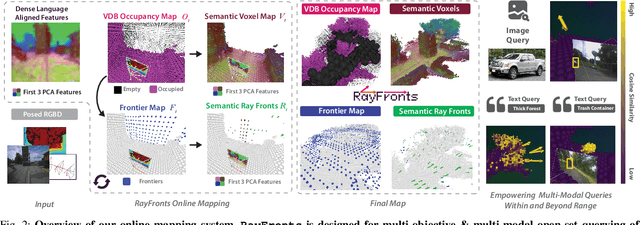
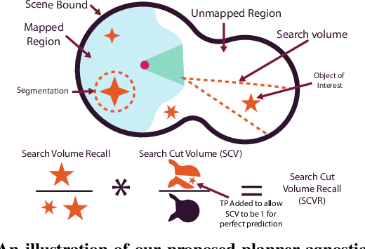
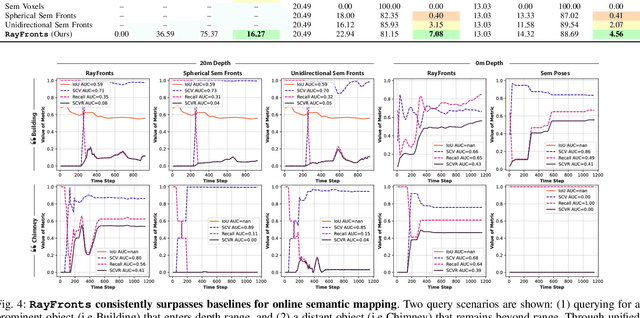
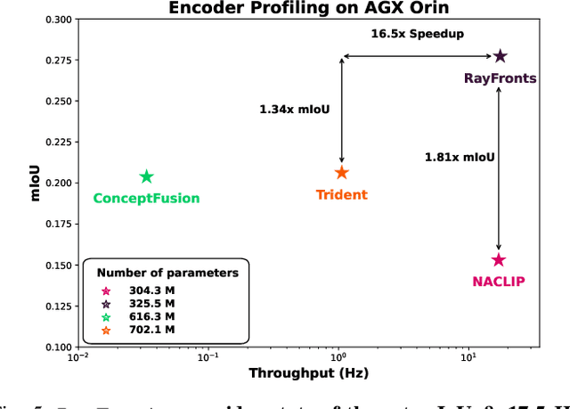
Open-set semantic mapping is crucial for open-world robots. Current mapping approaches either are limited by the depth range or only map beyond-range entities in constrained settings, where overall they fail to combine within-range and beyond-range observations. Furthermore, these methods make a trade-off between fine-grained semantics and efficiency. We introduce RayFronts, a unified representation that enables both dense and beyond-range efficient semantic mapping. RayFronts encodes task-agnostic open-set semantics to both in-range voxels and beyond-range rays encoded at map boundaries, empowering the robot to reduce search volumes significantly and make informed decisions both within & beyond sensory range, while running at 8.84 Hz on an Orin AGX. Benchmarking the within-range semantics shows that RayFronts's fine-grained image encoding provides 1.34x zero-shot 3D semantic segmentation performance while improving throughput by 16.5x. Traditionally, online mapping performance is entangled with other system components, complicating evaluation. We propose a planner-agnostic evaluation framework that captures the utility for online beyond-range search and exploration, and show RayFronts reduces search volume 2.2x more efficiently than the closest online baselines.
Aug3D: Augmenting large scale outdoor datasets for Generalizable Novel View Synthesis
Jan 11, 2025Recent photorealistic Novel View Synthesis (NVS) advances have increasingly gained attention. However, these approaches remain constrained to small indoor scenes. While optimization-based NVS models have attempted to address this, generalizable feed-forward methods, offering significant advantages, remain underexplored. In this work, we train PixelNeRF, a feed-forward NVS model, on the large-scale UrbanScene3D dataset. We propose four training strategies to cluster and train on this dataset, highlighting that performance is hindered by limited view overlap. To address this, we introduce Aug3D, an augmentation technique that leverages reconstructed scenes using traditional Structure-from-Motion (SfM). Aug3D generates well-conditioned novel views through grid and semantic sampling to enhance feed-forward NVS model learning. Our experiments reveal that reducing the number of views per cluster from 20 to 10 improves PSNR by 10%, but the performance remains suboptimal. Aug3D further addresses this by combining the newly generated novel views with the original dataset, demonstrating its effectiveness in improving the model's ability to predict novel views.
Map It Anywhere (MIA): Empowering Bird's Eye View Mapping using Large-scale Public Data
Jul 11, 2024


Top-down Bird's Eye View (BEV) maps are a popular representation for ground robot navigation due to their richness and flexibility for downstream tasks. While recent methods have shown promise for predicting BEV maps from First-Person View (FPV) images, their generalizability is limited to small regions captured by current autonomous vehicle-based datasets. In this context, we show that a more scalable approach towards generalizable map prediction can be enabled by using two large-scale crowd-sourced mapping platforms, Mapillary for FPV images and OpenStreetMap for BEV semantic maps. We introduce Map It Anywhere (MIA), a data engine that enables seamless curation and modeling of labeled map prediction data from existing open-source map platforms. Using our MIA data engine, we display the ease of automatically collecting a dataset of 1.2 million pairs of FPV images & BEV maps encompassing diverse geographies, landscapes, environmental factors, camera models & capture scenarios. We further train a simple camera model-agnostic model on this data for BEV map prediction. Extensive evaluations using established benchmarks and our dataset show that the data curated by MIA enables effective pretraining for generalizable BEV map prediction, with zero-shot performance far exceeding baselines trained on existing datasets by 35%. Our analysis highlights the promise of using large-scale public maps for developing & testing generalizable BEV perception, paving the way for more robust autonomous navigation.