Karel Zimmermann
Manual, Semi or Fully Autonomous Flipper Control? A Framework for Fair Comparison
Mar 18, 2025Abstract:We investigated the performance of existing semi- and fully autonomous methods for controlling flipper-based skid-steer robots. Our study involves reimplementation of these methods for fair comparison and it introduces a novel semi-autonomous control policy that provides a compelling trade-off among current state-of-the-art approaches. We also propose new metrics for assessing cognitive load and traversal quality and offer a benchmarking interface for generating Quality-Load graphs from recorded data. Our results, presented in a 2D Quality-Load space, demonstrate that the new control policy effectively bridges the gap between autonomous and manual control methods. Additionally, we reveal a surprising fact that fully manual, continuous control of all six degrees of freedom remains highly effective when performed by an experienced operator on a well-designed analog controller from third person view.
Let It Flow: Simultaneous Optimization of 3D Flow and Object Clustering
Apr 12, 2024Abstract:We study the problem of self-supervised 3D scene flow estimation from real large-scale raw point cloud sequences, which is crucial to various tasks like trajectory prediction or instance segmentation. In the absence of ground truth scene flow labels, contemporary approaches concentrate on deducing optimizing flow across sequential pairs of point clouds by incorporating structure based regularization on flow and object rigidity. The rigid objects are estimated by a variety of 3D spatial clustering methods. While state-of-the-art methods successfully capture overall scene motion using the Neural Prior structure, they encounter challenges in discerning multi-object motions. We identified the structural constraints and the use of large and strict rigid clusters as the main pitfall of the current approaches and we propose a novel clustering approach that allows for combination of overlapping soft clusters as well as non-overlapping rigid clusters representation. Flow is then jointly estimated with progressively growing non-overlapping rigid clusters together with fixed size overlapping soft clusters. We evaluate our method on multiple datasets with LiDAR point clouds, demonstrating the superior performance over the self-supervised baselines reaching new state of the art results. Our method especially excels in resolving flow in complicated dynamic scenes with multiple independently moving objects close to each other which includes pedestrians, cyclists and other vulnerable road users. Our codes will be publicly available.
Regularizing Self-supervised 3D Scene Flows with Surface Awareness and Cyclic Consistency
Dec 12, 2023Abstract:Learning without supervision how to predict 3D scene flows from point clouds is central to many vision systems. We propose a novel learning framework for this task which improves the necessary regularization. Relying on the assumption that scene elements are mostly rigid, current smoothness losses are built on the definition of ``rigid clusters" in the input point clouds. The definition of these clusters is challenging and has a major impact on the quality of predicted flows. We introduce two new consistency losses that enlarge clusters while preventing them from spreading over distinct objects. In particular, we enforce \emph{temporal} consistency with a forward-backward cyclic loss and \emph{spatial} consistency by considering surface orientation similarity in addition to spatial proximity. The proposed losses are model-independent and can thus be used in a plug-and-play fashion to significantly improve the performance of existing models, as demonstrated on two top-performing ones. We also showcase the effectiveness and generalization capability of our framework on four standard sensor-unique driving datasets, achieving state-of-the-art performance in 3D scene flow estimation. Our codes are available anonymously on \url{https://github.com/vacany/sac-flow}.
MonoForce: Self-supervised learning of physics-aware grey-box model for predicting the robot-terrain interaction
Sep 16, 2023


Abstract:We introduce an explainable, physics-aware, and end-to-end differentiable model which predicts the outcome of robot-terrain interaction from camera images. The proposed MonoForce model consists of a black-box module, which predicts robot-terrain interaction forces from the onboard camera, followed by a white-box module, which transforms these forces through the laws of classical mechanics into the predicted trajectories. As the white-box model is implemented as a differentiable ODE solver, it enables measuring the physical consistency between predicted forces and ground-truth trajectories of the robot. Consequently, it creates a self-supervised loss similar to MonoDepth. To facilitate the reproducibility of the paper, we provide the source code. See the project github for codes and supplementary materials such as videos and data sequences.
T-UDA: Temporal Unsupervised Domain Adaptation in Sequential Point Clouds
Sep 15, 2023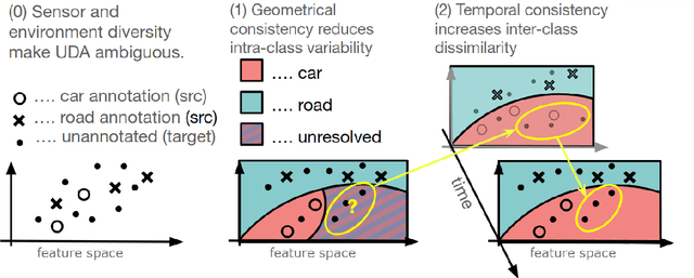
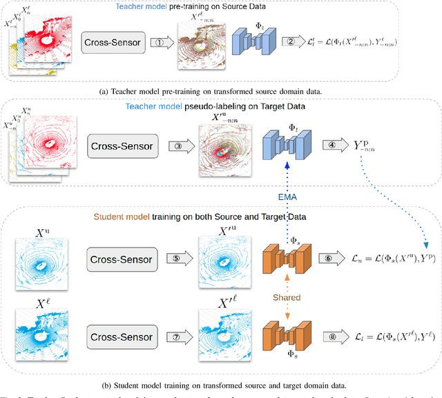
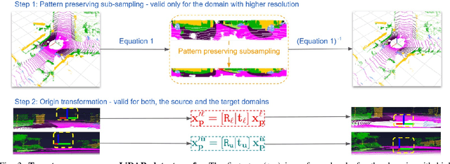
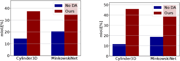
Abstract:Deep perception models have to reliably cope with an open-world setting of domain shifts induced by different geographic regions, sensor properties, mounting positions, and several other reasons. Since covering all domains with annotated data is technically intractable due to the endless possible variations, researchers focus on unsupervised domain adaptation (UDA) methods that adapt models trained on one (source) domain with annotations available to another (target) domain for which only unannotated data are available. Current predominant methods either leverage semi-supervised approaches, e.g., teacher-student setup, or exploit privileged data, such as other sensor modalities or temporal data consistency. We introduce a novel domain adaptation method that leverages the best of both trends. Our approach combines input data's temporal and cross-sensor geometric consistency with the mean teacher method. Dubbed T-UDA for "temporal UDA", such a combination yields massive performance gains for the task of 3D semantic segmentation of driving scenes. Experiments are conducted on Waymo Open Dataset, nuScenes and SemanticKITTI, for two popular 3D point cloud architectures, Cylinder3D and MinkowskiNet. Our codes are publicly available at https://github.com/ctu-vras/T-UDA.
Self-Supervised Depth Correction of Lidar Measurements from Map Consistency Loss
Mar 02, 2023Abstract:Depth perception is considered an invaluable source of information in the context of 3D mapping and various robotics applications. However, point cloud maps acquired using consumer-level light detection and ranging sensors (lidars) still suffer from bias related to local surface properties such as measuring beam-to-surface incidence angle, distance, texture, reflectance, or illumination conditions. This fact has recently motivated researchers to exploit traditional filters, as well as the deep learning paradigm, in order to suppress the aforementioned depth sensors error while preserving geometric and map consistency details. Despite the effort, depth correction of lidar measurements is still an open challenge mainly due to the lack of clean 3D data that could be used as ground truth. In this paper, we introduce two novel point cloud map consistency losses, which facilitate self-supervised learning on real data of lidar depth correction models. Specifically, the models exploit multiple point cloud measurements of the same scene from different view-points in order to learn to reduce the bias based on the constructed map consistency signal. Complementary to the removal of the bias from the measurements, we demonstrate that the depth correction models help to reduce localization drift. Additionally, we release a data set that contains point cloud data captured in an indoor corridor environment with precise localization and ground truth mapping information.
Similarity among the 2D-shapes and the analysis of dissimilarity scores
Nov 09, 2022Abstract:We present a conceptually simple and intuitive method to calculate and to measure the dissimilarities among 2D shapes. Several methods to interpret and to visualize the resulting dissimilarity matrix are presented and compared.
Teachers in concordance for pseudo-labeling of 3D sequential data
Jul 13, 2022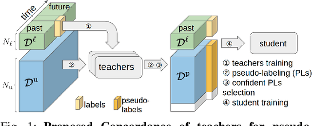

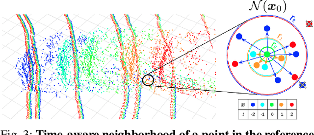
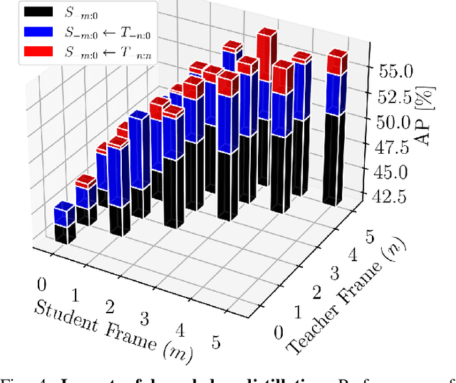
Abstract:Automatic pseudo-labeling is a powerful tool to tap into large amounts of sequential unlabeled data. It is especially appealing in safety-critical applications of autonomous driving where performance requirements are extreme, datasets large, and manual labeling is very challenging. We propose to leverage the sequentiality of the captures to boost the pseudo-labeling technique in a teacher-student setup via training multiple teachers, each with access to different temporal information. This set of teachers, dubbed Concordance, provides higher quality pseudo-labels for the student training than standard methods. The output of multiple teachers is combined via a novel pseudo-label confidence-guided criterion. Our experimental evaluation focuses on the 3D point cloud domain in urban driving scenarios. We show the performance of our method applied to multiple model architectures with tasks of 3D semantic segmentation and 3D object detection on two benchmark datasets. Our method, using only 20% of manual labels, outperforms some of the fully supervised methods. Special performance boost is achieved for classes rarely appearing in the training data, e.g., bicycles and pedestrians. The implementation of our approach is publicly available at https://github.com/ctu-vras/T-Concord3D.
System for multi-robotic exploration of underground environments CTU-CRAS-NORLAB in the DARPA Subterranean Challenge
Oct 12, 2021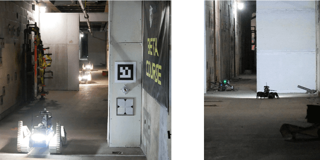
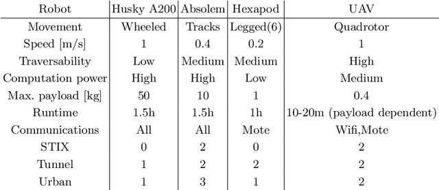
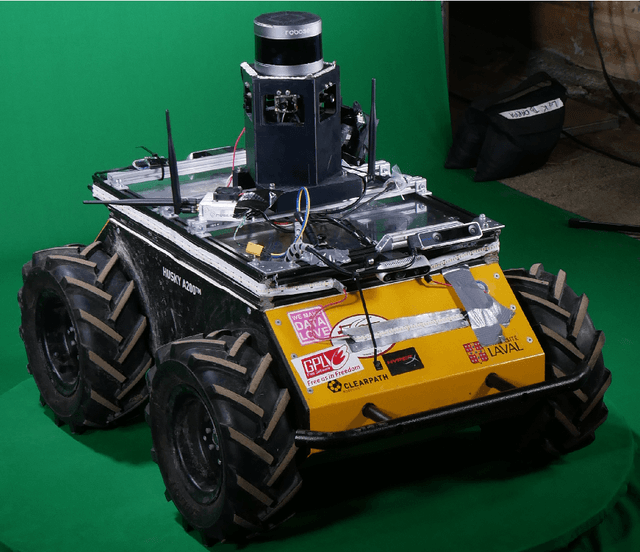
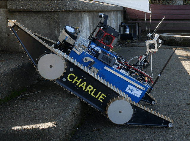
Abstract:We present a field report of CTU-CRAS-NORLAB team from the Subterranean Challenge (SubT) organised by the Defense Advanced Research Projects Agency (DARPA). The contest seeks to advance technologies that would improve the safety and efficiency of search-and-rescue operations in GPS-denied environments. During the contest rounds, teams of mobile robots have to find specific objects while operating in environments with limited radio communication, e.g. mining tunnels, underground stations or natural caverns. We present a heterogeneous exploration robotic system of the CTU-CRAS-NORLAB team, which achieved the third rank at the SubT Tunnel and Urban Circuit rounds and surpassed the performance of all other non-DARPA-funded teams. The field report describes the team's hardware, sensors, algorithms and strategies, and discusses the lessons learned by participating at the DARPA SubT contest.
Data-driven Policy Transfer with Imprecise Perception Simulation
Apr 05, 2018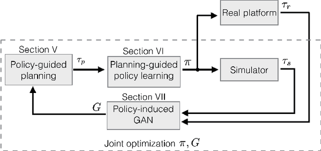
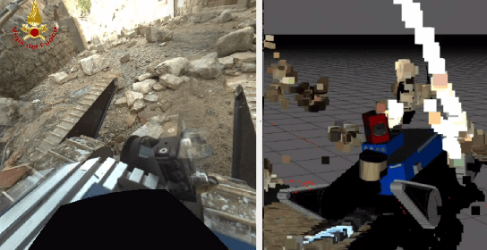
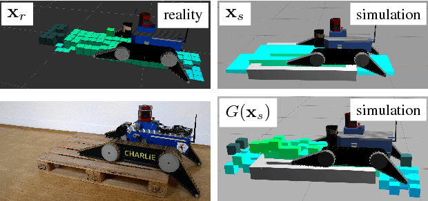
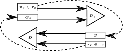
Abstract:The paper presents a complete pipeline for learning continuous motion control policies for a mobile robot when only a non-differentiable physics simulator of robot-terrain interactions is available. The multi-modal state estimation of the robot is also complex and difficult to simulate, so we simultaneously learn a generative model which refines simulator outputs. We propose a coarse-to-fine learning paradigm, where the coarse motion planning is alternated with imitation learning and policy transfer to the real robot. The policy is jointly optimized with the generative model. We evaluate the method on a real-world platform in a batch of experiments.
 Add to Chrome
 Add to Firefox
 Add to Edge