Junjie Lu
ParaMaP: Parallel Mapping and Collision-free Motion Planning for Reactive Robot Manipulation
Dec 27, 2025Abstract:Real-time and collision-free motion planning remains challenging for robotic manipulation in unknown environments due to continuous perception updates and the need for frequent online replanning. To address these challenges, we propose a parallel mapping and motion planning framework that tightly integrates Euclidean Distance Transform (EDT)-based environment representation with a sampling-based model predictive control (SMPC) planner. On the mapping side, a dense distance-field-based representation is constructed using a GPU-based EDT and augmented with a robot-masked update mechanism to prevent false self-collision detections during online perception. On the planning side, motion generation is formulated as a stochastic optimization problem with a unified objective function and efficiently solved by evaluating large batches of candidate rollouts in parallel within a SMPC framework, in which a geometrically consistent pose tracking metric defined on SE(3) is incorporated to ensure fast and accurate convergence to the target pose. The entire mapping and planning pipeline is implemented on the GPU to support high-frequency replanning. The effectiveness of the proposed framework is validated through extensive simulations and real-world experiments on a 7-DoF robotic manipulator. More details are available at: https://zxw610.github.io/ParaMaP.
YOPO-Rally: A Sim-to-Real Single-Stage Planner for Off-Road Terrain
May 24, 2025Abstract:Off-road navigation remains challenging for autonomous robots due to the harsh terrain and clustered obstacles. In this letter, we extend the YOPO (You Only Plan Once) end-to-end navigation framework to off-road environments, explicitly focusing on forest terrains, consisting of a high-performance, multi-sensor supported off-road simulator YOPO-Sim, a zero-shot transfer sim-to-real planner YOPO-Rally, and an MPC controller. Built on the Unity engine, the simulator can generate randomized forest environments and export depth images and point cloud maps for expert demonstrations, providing competitive performance with mainstream simulators. Terrain Traversability Analysis (TTA) processes cost maps, generating expert trajectories represented as non-uniform cubic Hermite curves. The planner integrates TTA and the pathfinding into a single neural network that inputs the depth image, current velocity, and the goal vector, and outputs multiple trajectory candidates with costs. The planner is trained by behavior cloning in the simulator and deployed directly into the real-world without fine-tuning. Finally, a series of simulated and real-world experiments is conducted to validate the performance of the proposed framework.
YOPOv2-Tracker: An End-to-End Agile Tracking and Navigation Framework from Perception to Action
May 11, 2025Abstract:Traditional target tracking pipelines including detection, mapping, navigation, and control are comprehensive but introduce high latency, limitting the agility of quadrotors. On the contrary, we follow the design principle of "less is more", striving to simplify the process while maintaining effectiveness. In this work, we propose an end-to-end agile tracking and navigation framework for quadrotors that directly maps the sensory observations to control commands. Importantly, leveraging the multimodal nature of navigation and detection tasks, our network maintains interpretability by explicitly integrating the independent modules of the traditional pipeline, rather than a crude action regression. In detail, we adopt a set of motion primitives as anchors to cover the searching space regarding the feasible region and potential target. Then we reformulate the trajectory optimization as regression of primitive offsets and associated costs considering the safety, smoothness, and other metrics. For tracking task, the trajectories are expected to approach the target and additional objectness scores are predicted. Subsequently, the predictions, after compensation for the estimated lumped disturbance, are transformed into thrust and attitude as control commands for swift response. During training, we seamlessly integrate traditional motion planning with deep learning by directly back-propagating the gradients of trajectory costs to the network, eliminating the need for expert demonstration in imitation learning and providing more direct guidance than reinforcement learning. Finally, we deploy the algorithm on a compact quadrotor and conduct real-world validations in both forest and building environments to demonstrate the efficiency of the proposed method.
AdaptiveStep: Automatically Dividing Reasoning Step through Model Confidence
Feb 19, 2025Abstract:Current approaches for training Process Reward Models (PRMs) often involve breaking down responses into multiple reasoning steps using rule-based techniques, such as using predefined placeholder tokens or setting the reasoning step's length into a fixed size. These approaches overlook the fact that specific words do not typically mark true decision points in a text. To address this, we propose AdaptiveStep, a method that divides reasoning steps based on the model's confidence in predicting the next word. This division method provides more decision-making information at each step, enhancing downstream tasks, such as reward model learning. Moreover, our method does not require manual annotation. We demonstrate its effectiveness through experiments with AdaptiveStep-trained PRMs in mathematical reasoning and code generation tasks. Experimental results indicate that the outcome PRM achieves state-of-the-art Best-of-N performance, surpassing greedy search strategy with token-level value-guided decoding, while also reducing construction costs by over 30% compared to existing open-source PRMs. In addition, we provide a thorough analysis and case study on the PRM's performance, transferability, and generalization capabilities.
Sampling-Based Hierarchical Trajectory Planning for Formation Flight
Jul 24, 2024Abstract:Formation flight of unmanned aerial vehicles (UAVs) poses significant challenges in terms of safety and formation keeping, particularly in cluttered environments. However, existing methods often struggle to simultaneously satisfy these two critical requirements. To address this issue, this paper proposes a sampling-based trajectory planning method with a hierarchical structure for formation flight in dense obstacle environments. To ensure reliable local sensing information sharing among UAVs, each UAV generates a safe flight corridor (SFC), which is transmitted to the leader UAV. Subsequently, a sampling-based formation guidance path generation method is designed as the front-end strategy, steering the formation to fly in the desired shape safely with the formation connectivity provided by the SFCs. Furthermore, a model predictive path integral (MPPI) based distributed trajectory optimization method is developed as the back-end part, which ensures the smoothness, safety and dynamics feasibility of the executable trajectory. To validate the efficiency of the developed algorithm, comprehensive simulation comparisons are conducted. The supplementary simulation video can be seen at https://www.youtube.com/watch?v=xSxbUN0tn1M.
2DLIW-SLAM:2D LiDAR-Inertial-Wheel Odometry with Real-Time Loop Closure
Apr 15, 2024Abstract:Due to budgetary constraints, indoor navigation typically employs 2D LiDAR rather than 3D LiDAR. However, the utilization of 2D LiDAR in Simultaneous Localization And Mapping (SLAM) frequently encounters challenges related to motion degeneracy, particularly in geometrically similar environments. To address this problem, this paper proposes a robust, accurate, and multi-sensor-fused 2D LiDAR SLAM system specifically designed for indoor mobile robots. To commence, the original LiDAR data undergoes meticulous processing through point and line extraction. Leveraging the distinctive characteristics of indoor environments, line-line constraints are established to complement other sensor data effectively, thereby augmenting the overall robustness and precision of the system. Concurrently, a tightly-coupled front-end is created, integrating data from the 2D LiDAR, IMU, and wheel odometry, thus enabling real-time state estimation. Building upon this solid foundation, a novel global feature point matching-based loop closure detection algorithm is proposed. This algorithm proves highly effective in mitigating front-end accumulated errors and ultimately constructs a globally consistent map. The experimental results indicate that our system fully meets real-time requirements. When compared to Cartographer, our system not only exhibits lower trajectory errors but also demonstrates stronger robustness, particularly in degeneracy problem.
ML-Bench: Large Language Models Leverage Open-source Libraries for Machine Learning Tasks
Nov 16, 2023


Abstract:Large language models have shown promising performance in code generation benchmarks. However, a considerable divide exists between these benchmark achievements and their practical applicability, primarily attributed to real-world programming's reliance on pre-existing libraries. Instead of evaluating LLMs to code from scratch, this work aims to propose a new evaluation setup where LLMs use open-source libraries to finish machine learning tasks. Therefore, we propose ML-Bench, an expansive benchmark developed to assess the effectiveness of LLMs in leveraging existing functions in open-source libraries. Consisting of 10044 samples spanning 130 tasks over 14 notable machine learning GitHub repositories. In this setting, given a specific machine learning task instruction and the accompanying README in a codebase, an LLM is tasked to generate code to accomplish the task. This necessitates the comprehension of long and language-code interleaved documents, as well as the understanding of complex cross-file code structures, introducing new challenges. Notably, while GPT-4 exhibits remarkable improvement over other LLMs, it manages to accomplish only 39.73\% of the tasks, leaving a huge space for improvement. We address these challenges by proposing ML-Agent, designed to effectively navigate the codebase, locate documentation, retrieve code, and generate executable code. Empirical results demonstrate that ML-Agent, built upon GPT-4, results in further improvements. Code, data, and models are available at \url{https://ml-bench.github.io/}.
TMSTC*: A Turn-minimizing Algorithm For Multi-robot Coverage Path Planning
Dec 05, 2022


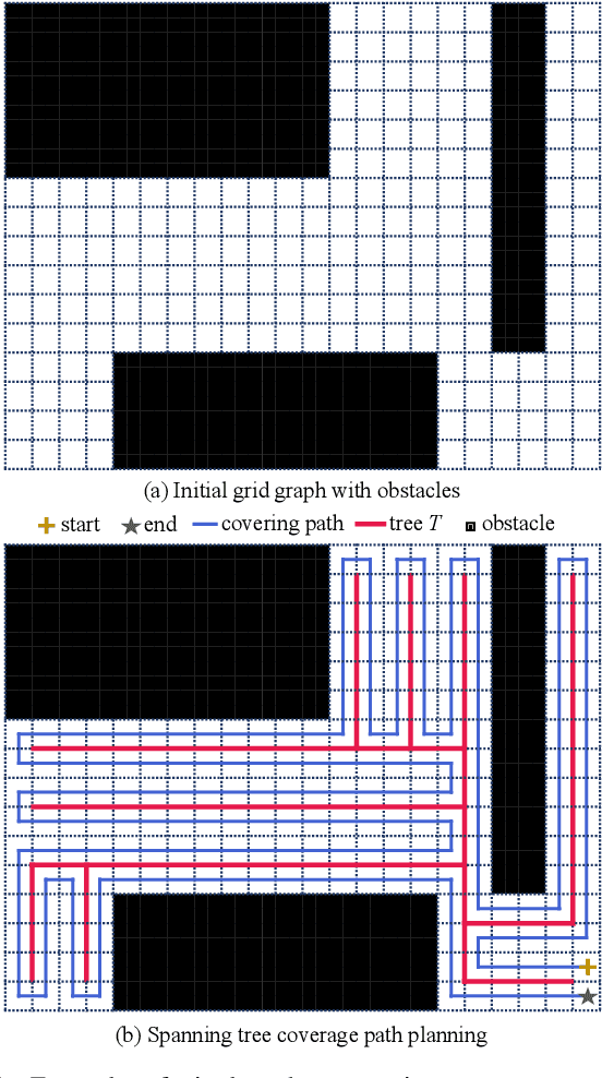
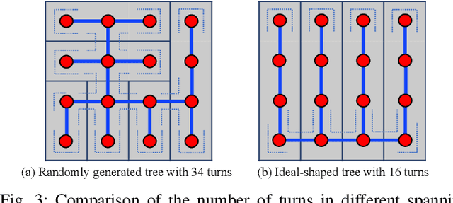
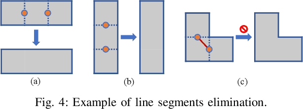
Abstract:Coverage path planning is a major application for mobile robots, which requires robots to move along a planned path to cover the entire map. For large-scale tasks, coverage path planning benefits greatly from multiple robots. In this paper, we describe Turn-minimizing Multirobot Spanning Tree Coverage Star(TMSTC*), an improved multirobot coverage path planning (mCPP) algorithm based on the MSTC*. Our algorithm partitions the map into minimum bricks as tree's branches and thereby transforms the problem into finding the maximum independent set of bipartite graph. We then connect bricks with greedy strategy to form a tree, aiming to reduce the number of turns of corresponding circumnavigating coverage path. Our experimental results show that our approach enables multiple robots to make fewer turns and thus complete terrain coverage tasks faster than other popular algorithms.
 Add to Chrome
 Add to Firefox
 Add to Edge