Guodong Fan
RefProtoFL: Communication-Efficient Federated Learning via External-Referenced Prototype Alignment
Jan 21, 2026Abstract:Federated learning (FL) enables collaborative model training without sharing raw data in edge environments, but is constrained by limited communication bandwidth and heterogeneous client data distributions. Prototype-based FL mitigates this issue by exchanging class-wise feature prototypes instead of full model parameters; however, existing methods still suffer from suboptimal generalization under severe communication constraints. In this paper, we propose RefProtoFL, a communication-efficient FL framework that integrates External-Referenced Prototype Alignment (ERPA) for representation consistency with Adaptive Probabilistic Update Dropping (APUD) for communication efficiency. Specifically, we decompose the model into a private backbone and a lightweight shared adapter, and restrict federated communication to the adapter parameters only. To further reduce uplink cost, APUD performs magnitude-aware Top-K sparsification, transmitting only the most significant adapter updates for server-side aggregation. To address representation inconsistency across heterogeneous clients, ERPA leverages a small server-held public dataset to construct external reference prototypes that serve as shared semantic anchors. For classes covered by public data, clients directly align local representations to public-induced prototypes, whereas for uncovered classes, alignment relies on server-aggregated global reference prototypes via weighted averaging. Extensive experiments on standard benchmarks demonstrate that RefProtoFL attains higher classification accuracy than state-of-the-art prototype-based FL baselines.
Wavelet-Guided Dual-Frequency Encoding for Remote Sensing Change Detection
Aug 07, 2025Abstract:Change detection in remote sensing imagery plays a vital role in various engineering applications, such as natural disaster monitoring, urban expansion tracking, and infrastructure management. Despite the remarkable progress of deep learning in recent years, most existing methods still rely on spatial-domain modeling, where the limited diversity of feature representations hinders the detection of subtle change regions. We observe that frequency-domain feature modeling particularly in the wavelet domain an amplify fine-grained differences in frequency components, enhancing the perception of edge changes that are challenging to capture in the spatial domain. Thus, we propose a method called Wavelet-Guided Dual-Frequency Encoding (WGDF). Specifically, we first apply Discrete Wavelet Transform (DWT) to decompose the input images into high-frequency and low-frequency components, which are used to model local details and global structures, respectively. In the high-frequency branch, we design a Dual-Frequency Feature Enhancement (DFFE) module to strengthen edge detail representation and introduce a Frequency-Domain Interactive Difference (FDID) module to enhance the modeling of fine-grained changes. In the low-frequency branch, we exploit Transformers to capture global semantic relationships and employ a Progressive Contextual Difference Module (PCDM) to progressively refine change regions, enabling precise structural semantic characterization. Finally, the high- and low-frequency features are synergistically fused to unify local sensitivity with global discriminability. Extensive experiments on multiple remote sensing datasets demonstrate that WGDF significantly alleviates edge ambiguity and achieves superior detection accuracy and robustness compared to state-of-the-art methods. The code will be available at https://github.com/boshizhang123/WGDF.
Prototype-Driven Structure Synergy Network for Remote Sensing Images Segmentation
Aug 06, 2025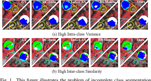
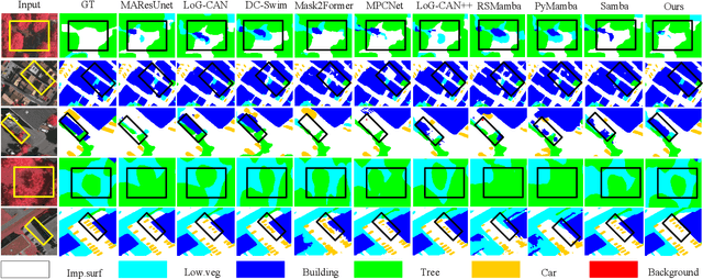
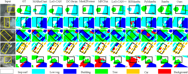
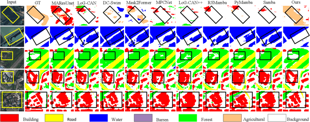
Abstract:In the semantic segmentation of remote sensing images, acquiring complete ground objects is critical for achieving precise analysis. However, this task is severely hindered by two major challenges: high intra-class variance and high inter-class similarity. Traditional methods often yield incomplete segmentation results due to their inability to effectively unify class representations and distinguish between similar features. Even emerging class-guided approaches are limited by coarse class prototype representations and a neglect of target structural information. Therefore, this paper proposes a Prototype-Driven Structure Synergy Network (PDSSNet). The design of this network is based on a core concept, a complete ground object is jointly defined by its invariant class semantics and its variant spatial structure. To implement this, we have designed three key modules. First, the Adaptive Prototype Extraction Module (APEM) ensures semantic accuracy from the source by encoding the ground truth to extract unbiased class prototypes. Subsequently, the designed Semantic-Structure Coordination Module (SSCM) follows a hierarchical semantics-first, structure-second principle. This involves first establishing a global semantic cognition, then leveraging structural information to constrain and refine the semantic representation, thereby ensuring the integrity of class information. Finally, the Channel Similarity Adjustment Module (CSAM) employs a dynamic step-size adjustment mechanism to focus on discriminative features between classes. Extensive experiments demonstrate that PDSSNet outperforms state-of-the-art methods. The source code is available at https://github.com/wangjunyi-1/PDSSNet.
Efficient Federated Learning with Encrypted Data Sharing for Data-Heterogeneous Edge Devices
Jun 25, 2025Abstract:As privacy protection gains increasing importance, more models are being trained on edge devices and subsequently merged into the central server through Federated Learning (FL). However, current research overlooks the impact of network topology, physical distance, and data heterogeneity on edge devices, leading to issues such as increased latency and degraded model performance. To address these issues, we propose a new federated learning scheme on edge devices that called Federated Learning with Encrypted Data Sharing(FedEDS). FedEDS uses the client model and the model's stochastic layer to train the data encryptor. The data encryptor generates encrypted data and shares it with other clients. The client uses the corresponding client's stochastic layer and encrypted data to train and adjust the local model. FedEDS uses the client's local private data and encrypted shared data from other clients to train the model. This approach accelerates the convergence speed of federated learning training and mitigates the negative impact of data heterogeneity, making it suitable for application services deployed on edge devices requiring rapid convergence. Experiments results show the efficacy of FedEDS in promoting model performance.
Can LLMs Replace Human Evaluators? An Empirical Study of LLM-as-a-Judge in Software Engineering
Feb 10, 2025Abstract:Recently, large language models (LLMs) have been deployed to tackle various software engineering (SE) tasks like code generation, significantly advancing the automation of SE tasks. However, assessing the quality of these LLM-generated code and text remains challenging. The commonly used Pass@k metric necessitates extensive unit tests and configured environments, demands a high labor cost, and is not suitable for evaluating LLM-generated text. Conventional metrics like BLEU, which measure only lexical rather than semantic similarity, have also come under scrutiny. In response, a new trend has emerged to employ LLMs for automated evaluation, known as LLM-as-a-judge. These LLM-as-a-judge methods are claimed to better mimic human assessment than conventional metrics without relying on high-quality reference answers. Nevertheless, their exact human alignment in SE tasks remains unexplored. In this paper, we empirically explore LLM-as-a-judge methods for evaluating SE tasks, focusing on their alignment with human judgments. We select seven LLM-as-a-judge methods that utilize general-purpose LLMs, alongside two LLMs specifically fine-tuned for evaluation. After generating and manually scoring LLM responses on three recent SE datasets of code translation, code generation, and code summarization, we then prompt these methods to evaluate each response. Finally, we compare the scores generated by these methods with human evaluation. The results indicate that output-based methods reach the highest Pearson correlation of 81.32 and 68.51 with human scores in code translation and generation, achieving near-human evaluation, noticeably outperforming ChrF++, one of the best conventional metrics, at 34.23 and 64.92. Such output-based methods prompt LLMs to output judgments directly, and exhibit more balanced score distributions that resemble human score patterns. Finally, we provide...
FairSort: Learning to Fair Rank for Personalized Recommendations in Two-Sided Platforms
Nov 30, 2024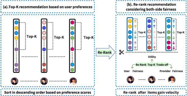


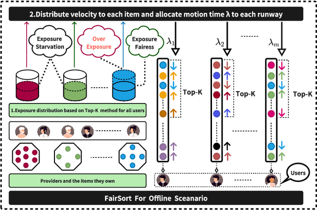
Abstract:Traditional recommendation systems focus on maximizing user satisfaction by suggesting their favorite items. This user-centric approach may lead to unfair exposure distribution among the providers. On the contrary, a provider-centric design might become unfair to the users. Therefore, this paper proposes a re-ranking model FairSort\footnote{\textbf{Reproducibility:}The code and datasets are available at \url{https://github.com/13543024276/FairSort}} to find a trade-off solution among user-side fairness, provider-side fairness, and personalized recommendations utility. Previous works habitually treat this issue as a knapsack problem, incorporating both-side fairness as constraints. In this paper, we adopt a novel perspective, treating each recommendation list as a runway rather than a knapsack. In this perspective, each item on the runway gains a velocity and runs within a specific time, achieving re-ranking for both-side fairness. Meanwhile, we ensure the Minimum Utility Guarantee for personalized recommendations by designing a Binary Search approach. This can provide more reliable recommendations compared to the conventional greedy strategy based on the knapsack problem. We further broaden the applicability of FairSort, designing two versions for online and offline recommendation scenarios. Theoretical analysis and extensive experiments on real-world datasets indicate that FairSort can ensure more reliable personalized recommendations while considering fairness for both the provider and user.
FDCE-Net: Underwater Image Enhancement with Embedding Frequency and Dual Color Encoder
Apr 27, 2024


Abstract:Underwater images often suffer from various issues such as low brightness, color shift, blurred details, and noise due to light absorption and scattering caused by water and suspended particles. Previous underwater image enhancement (UIE) methods have primarily focused on spatial domain enhancement, neglecting the frequency domain information inherent in the images. However, the degradation factors of underwater images are closely intertwined in the spatial domain. Although certain methods focus on enhancing images in the frequency domain, they overlook the inherent relationship between the image degradation factors and the information present in the frequency domain. As a result, these methods frequently enhance certain attributes of the improved image while inadequately addressing or even exacerbating other attributes. Moreover, many existing methods heavily rely on prior knowledge to address color shift problems in underwater images, limiting their flexibility and robustness. In order to overcome these limitations, we propose the Embedding Frequency and Dual Color Encoder Network (FDCE-Net) in our paper. The FDCE-Net consists of two main structures: (1) Frequency Spatial Network (FS-Net) aims to achieve initial enhancement by utilizing our designed Frequency Spatial Residual Block (FSRB) to decouple image degradation factors in the frequency domain and enhance different attributes separately. (2) To tackle the color shift issue, we introduce the Dual-Color Encoder (DCE). The DCE establishes correlations between color and semantic representations through cross-attention and leverages multi-scale image features to guide the optimization of adaptive color query. The final enhanced images are generated by combining the outputs of FS-Net and DCE through a fusion network. These images exhibit rich details, clear textures, low noise and natural colors.
Spatial-frequency Dual-Domain Feature Fusion Network for Low-Light Remote Sensing Image Enhancement
Apr 26, 2024


Abstract:Low-light remote sensing images generally feature high resolution and high spatial complexity, with continuously distributed surface features in space. This continuity in scenes leads to extensive long-range correlations in spatial domains within remote sensing images. Convolutional Neural Networks, which rely on local correlations for long-distance modeling, struggle to establish long-range correlations in such images. On the other hand, transformer-based methods that focus on global information face high computational complexities when processing high-resolution remote sensing images. From another perspective, Fourier transform can compute global information without introducing a large number of parameters, enabling the network to more efficiently capture the overall image structure and establish long-range correlations. Therefore, we propose a Dual-Domain Feature Fusion Network (DFFN) for low-light remote sensing image enhancement. Specifically, this challenging task of low-light enhancement is divided into two more manageable sub-tasks: the first phase learns amplitude information to restore image brightness, and the second phase learns phase information to refine details. To facilitate information exchange between the two phases, we designed an information fusion affine block that combines data from different phases and scales. Additionally, we have constructed two dark light remote sensing datasets to address the current lack of datasets in dark light remote sensing image enhancement. Extensive evaluations show that our method outperforms existing state-of-the-art methods. The code is available at https://github.com/iijjlk/DFFN.
 Add to Chrome
 Add to Firefox
 Add to Edge