Emilio Olivastri
DISF: Disentangled Iterative Surface Fitting for Contact-stable Grasp Planning with Grasp Pose Alignment to the Object Center of Mass
Dec 31, 2025Abstract:In this work, we address the limitation of surface fitting-based grasp planning algorithm, which primarily focuses on geometric alignment between the gripper and object surface while overlooking the stability of contact point distribution, often resulting in unstable grasps due to inadequate contact configurations. To overcome this limitation, we propose a novel surface fitting algorithm that integrates contact stability while preserving geometric compatibility. Inspired by human grasping behavior, our method disentangles the grasp pose optimization into three sequential steps: (1) rotation optimization to align contact normals, (2) translation refinement to improve the alignment between the gripper frame origin and the object Center of Mass (CoM), and (3) gripper aperture adjustment to optimize contact point distribution. We validate our approach in simulation across 15 objects under both Known-shape (with clean CAD-derived dataset) and Observed-shape (with YCB object dataset) settings, including cross-platform grasp execution on three robot--gripper platforms. We further validate the method in real-world grasp experiments on a UR3e robot. Overall, DISF reduces CoM misalignment while maintaining geometric compatibility, translating into higher grasp success in both simulation and real-world execution compared to baselines. Additional videos and supplementary results are available on our project page: https://tomoya-yamanokuchi.github.io/disf-ras-project-page/
Disentangled Iterative Surface Fitting for Contact-stable Grasp Planning
Feb 17, 2025Abstract:In this work, we address the limitation of surface fitting-based grasp planning algorithm, which primarily focuses on geometric alignment between the gripper and object surface while overlooking the stability of contact point distribution, often resulting in unstable grasps due to inadequate contact configurations. To overcome this limitation, we propose a novel surface fitting algorithm that integrates contact stability while preserving geometric compatibility. Inspired by human grasping behavior, our method disentangles the grasp pose optimization into three sequential steps: (1) rotation optimization to align contact normals, (2) translation refinement to improve Center of Mass (CoM) alignment, and (3) gripper aperture adjustment to optimize contact point distribution. We validate our approach through simulations on ten YCB dataset objects, demonstrating an 80% improvement in grasp success over conventional surface fitting methods that disregard contact stability. Further details can be found on our project page: https://tomoya-yamanokuchi.github.io/disf-project-page/.
Multi-Modal 3D Scene Graph Updater for Shared and Dynamic Environments
Nov 05, 2024

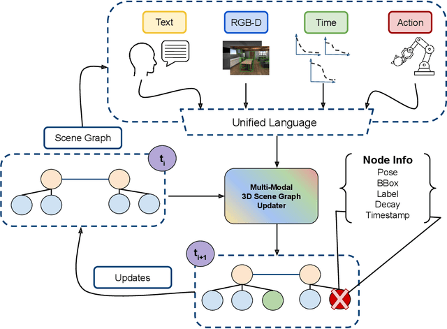
Abstract:The advent of generalist Large Language Models (LLMs) and Large Vision Models (VLMs) have streamlined the construction of semantically enriched maps that can enable robots to ground high-level reasoning and planning into their representations. One of the most widely used semantic map formats is the 3D Scene Graph, which captures both metric (low-level) and semantic (high-level) information. However, these maps often assume a static world, while real environments, like homes and offices, are dynamic. Even small changes in these spaces can significantly impact task performance. To integrate robots into dynamic environments, they must detect changes and update the scene graph in real-time. This update process is inherently multimodal, requiring input from various sources, such as human agents, the robot's own perception system, time, and its actions. This work proposes a framework that leverages these multimodal inputs to maintain the consistency of scene graphs during real-time operation, presenting promising initial results and outlining a roadmap for future research.
IPC: Incremental Probabilistic Consensus-based Consistent Set Maximization for SLAM Backends
May 14, 2024Abstract:In SLAM (Simultaneous localization and mapping) problems, Pose Graph Optimization (PGO) is a technique to refine an initial estimate of a set of poses (positions and orientations) from a set of pairwise relative measurements. The optimization procedure can be negatively affected even by a single outlier measurement, with possible catastrophic and meaningless results. Although recent works on robust optimization aim to mitigate the presence of outlier measurements, robust solutions capable of handling large numbers of outliers are yet to come. This paper presents IPC, acronym for Incremental Probabilistic Consensus, a method that approximates the solution to the combinatorial problem of finding the maximally consistent set of measurements in an incremental fashion. It evaluates the consistency of each loop closure measurement through a consensus-based procedure, possibly applied to a subset of the global problem, where all previously integrated inlier measurements have veto power. We evaluated IPC on standard benchmarks against several state-of-the-art methods. Although it is simple and relatively easy to implement, IPC competes with or outperforms the other tested methods in handling outliers while providing online performances. We release with this paper an open-source implementation of the proposed method.
* This paper has been accepted for publication at the 2024 IEEE International Conference on Robotics and Automation (ICRA)
A Sonar-based AUV Positioning System for Underwater Environments with Low Infrastructure Density
May 03, 2024Abstract:The increasing demand for underwater vehicles highlights the necessity for robust localization solutions in inspection missions. In this work, we present a novel real-time sonar-based underwater global positioning algorithm for AUVs (Autonomous Underwater Vehicles) designed for environments with a sparse distribution of human-made assets. Our approach exploits two synergistic data interpretation frontends applied to the same stream of sonar data acquired by a multibeam Forward-Looking Sonar (FSD). These observations are fused within a Particle Filter (PF) either to weigh more particles that belong to high-likelihood regions or to solve symmetric ambiguities. Preliminary experiments carried out on a simulated environment resembling a real underwater plant provided promising results. This work represents a starting point towards future developments of the method and consequent exhaustive evaluations also in real-world scenarios.
* Accepted to the IEEE ICRA Workshop on Field Robotics 2024
Improving Generalization of Synthetically Trained Sonar Image Descriptors for Underwater Place Recognition
Aug 02, 2023Abstract:Autonomous navigation in underwater environments presents challenges due to factors such as light absorption and water turbidity, limiting the effectiveness of optical sensors. Sonar systems are commonly used for perception in underwater operations as they are unaffected by these limitations. Traditional computer vision algorithms are less effective when applied to sonar-generated acoustic images, while convolutional neural networks (CNNs) typically require large amounts of labeled training data that are often unavailable or difficult to acquire. To this end, we propose a novel compact deep sonar descriptor pipeline that can generalize to real scenarios while being trained exclusively on synthetic data. Our architecture is based on a ResNet18 back-end and a properly parameterized random Gaussian projection layer, whereas input sonar data is enhanced with standard ad-hoc normalization/prefiltering techniques. A customized synthetic data generation procedure is also presented. The proposed method has been evaluated extensively using both synthetic and publicly available real data, demonstrating its effectiveness compared to state-of-the-art methods.
A Graph-based Optimization Framework for Hand-Eye Calibration for Multi-Camera Setups
Mar 08, 2023


Abstract:Hand-eye calibration is the problem of estimating the spatial transformation between a reference frame, usually the base of a robot arm or its gripper, and the reference frame of one or multiple cameras. Generally, this calibration is solved as a non-linear optimization problem, what instead is rarely done is to exploit the underlying graph structure of the problem itself. Actually, the problem of hand-eye calibration can be seen as an instance of the Simultaneous Localization and Mapping (SLAM) problem. Inspired by this fact, in this work we present a pose-graph approach to the hand-eye calibration problem that extends a recent state-of-the-art solution in two different ways: i) by formulating the solution to eye-on-base setups with one camera; ii) by covering multi-camera robotic setups. The proposed approach has been validated in simulation against standard hand-eye calibration methods. Moreover, a real application is shown. In both scenarios, the proposed approach overcomes all alternative methods. We release with this paper an open-source implementation of our graph-based optimization framework for multi-camera setups.
Pushing the Limits of Learning-based Traversability Analysis for Autonomous Driving on CPU
Jun 07, 2022


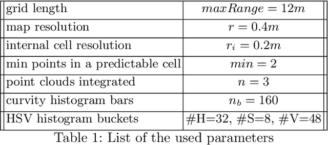
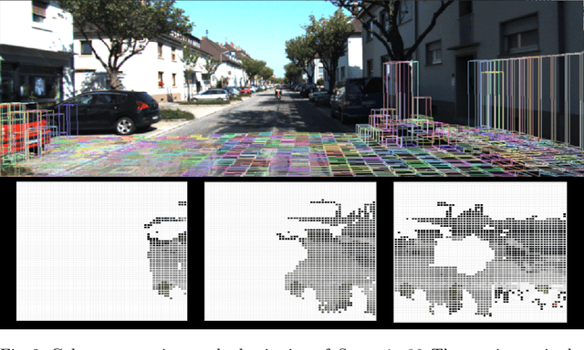
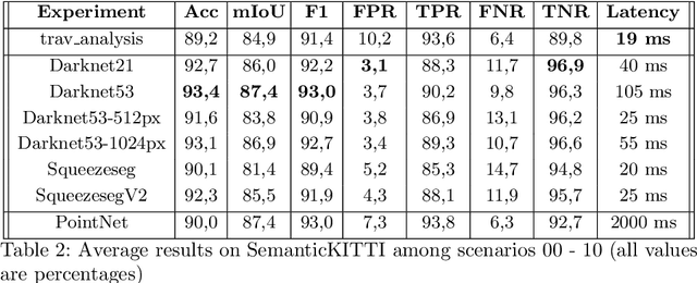
Abstract:Self-driving vehicles and autonomous ground robots require a reliable and accurate method to analyze the traversability of the surrounding environment for safe navigation. This paper proposes and evaluates a real-time machine learning-based Traversability Analysis method that combines geometric features with appearance-based features in a hybrid approach based on a SVM classifier. In particular, we show that integrating a new set of geometric and visual features and focusing on important implementation details enables a noticeable boost in performance and reliability. The proposed approach has been compared with state-of-the-art Deep Learning approaches on a public dataset of outdoor driving scenarios. It reaches an accuracy of 89.2% in scenarios of varying complexity, demonstrating its effectiveness and robustness. The method runs fully on CPU and reaches comparable results with respect to the other methods, operates faster, and requires fewer hardware resources.
 Add to Chrome
 Add to Firefox
 Add to Edge