Zhengyu Wang
FinMMDocR: Benchmarking Financial Multimodal Reasoning with Scenario Awareness, Document Understanding, and Multi-Step Computation
Dec 31, 2025Abstract:We introduce FinMMDocR, a novel bilingual multimodal benchmark for evaluating multimodal large language models (MLLMs) on real-world financial numerical reasoning. Compared to existing benchmarks, our work delivers three major advancements. (1) Scenario Awareness: 57.9% of 1,200 expert-annotated problems incorporate 12 types of implicit financial scenarios (e.g., Portfolio Management), challenging models to perform expert-level reasoning based on assumptions; (2) Document Understanding: 837 Chinese/English documents spanning 9 types (e.g., Company Research) average 50.8 pages with rich visual elements, significantly surpassing existing benchmarks in both breadth and depth of financial documents; (3) Multi-Step Computation: Problems demand 11-step reasoning on average (5.3 extraction + 5.7 calculation steps), with 65.0% requiring cross-page evidence (2.4 pages average). The best-performing MLLM achieves only 58.0% accuracy, and different retrieval-augmented generation (RAG) methods show significant performance variations on this task. We expect FinMMDocR to drive improvements in MLLMs and reasoning-enhanced methods on complex multimodal reasoning tasks in real-world scenarios.
Source Localization and Power Estimation through RISs: Performance Analysis and Prototype Validations
Dec 12, 2025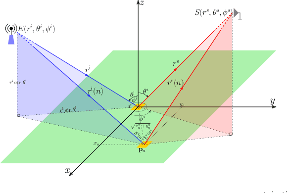


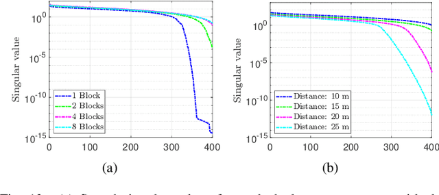
Abstract:This paper investigates the capabilities and effectiveness of backward localization centered on reconfigurable intelligent surfaces (RISs). In the backward sensing paradigm, the region of interest (RoI) is illuminated using a set of diverse radiation patterns. These patterns encode spatial information into a sequence of measurements, which are subsequently processed to reconstruct the RoI. We show that a single RIS can estimate the direction of arrival of incident waves by leveraging configurational diversity, and that the spatial diversity provided by multiple RISs further improves the accuracy of source localization and power estimation. The underlying structure of the sensing operator in the multi-snapshot measurement process is clarified. For single-RIS localization, the sensing operator is decomposed into a product of structured matrices, each corresponding to a specific physical process: wave propagation to and from the RIS, the relative phase offsets of elements with respect to the reference point, and the applied phase configuration of each element. A unified framework for identifying key performance indicators is established by analyzing the conditioning of the sensing operators. In the multi-RIS setting, we derive--via rank analysis--the governing law among the RoI size, the number of elements, and the number of measurements. Upper bounds on the relative error of the least squares reconstruction algorithm are derived. These bounds clarify how key performance indicators affect estimation error and provide valuable guidance for system-level optimization. Numerical experiments confirm that the trend of the relative error is consistent with the theoretical bounds.
A Large-dimensional Analysis of ESPRIT DoA Estimation: Inconsistency and a Correction via RMT
Jan 06, 2025
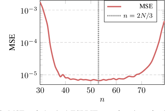
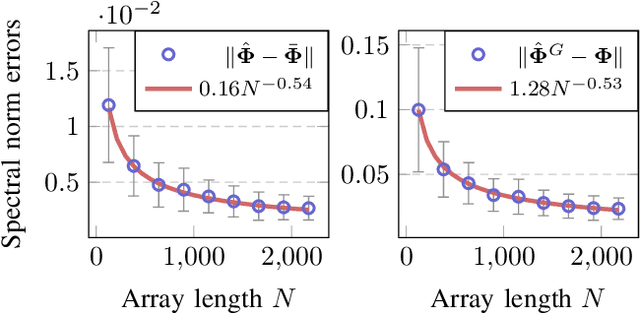
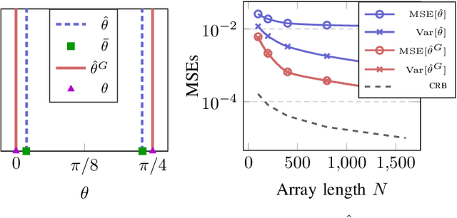
Abstract:In this paper, we perform asymptotic analyses of the widely used ESPRIT direction-of-arrival (DoA) estimator for large arrays, where the array size $N$ and the number of snapshots $T$ grow to infinity at the same pace. In this large-dimensional regime, the sample covariance matrix (SCM) is known to be a poor eigenspectral estimator of the population covariance. We show that the classical ESPRIT algorithm, that relies on the SCM, and as a consequence of the large-dimensional inconsistency of the SCM, produces inconsistent DoA estimates as $N,T \to \infty$ with $N/T \to c \in (0,\infty)$, for both widely- and closely-spaced DoAs. Leveraging tools from random matrix theory (RMT), we propose an improved G-ESPRIT method and prove its consistency in the same large-dimensional setting. From a technical perspective, we derive a novel bound on the eigenvalue differences between two potentially non-Hermitian random matrices, which may be of independent interest. Numerical simulations are provided to corroborate our theoretical findings.
Toward Wireless Localization Using Multiple Reconfigurable Intelligent Surfaces
Jul 30, 2024Abstract:This paper investigates the capabilities and effectiveness of backward sensing centered on reconfigurable intelligent surfaces (RISs). We demonstrate that the direction of arrival (DoA) estimation of incident waves in the far-field regime can be accomplished using a single RIS by leveraging configurational diversity. Furthermore, we identify that the spatial diversity achieved through deploying multiple RISs enables accurate localization of multiple power sources. Physically accurate and mathematically concise models are introduced to characterize forward signal aggregations via RISs. By employing linearized approximations inherent in the far-field region, the measurement process for various configurations can be expressed as a system of linear equations. The mathematical essence of backward sensing lies in solving this system. A theoretical framework for determining key performance indicators is established through condition number analysis of the sensing operators. In the context of localization using multiple RISs, we examine relationships among the rank of sensing operators, the size of the region of interest (RoI), and the number of elements and measurements. For DoA estimations, we provide an upper bound for the relative error of the least squares reconstruction algorithm. These quantitative analyses offer essential insights for system design and optimization. Numerical experiments validate our findings. To demonstrate the practicality of our proposed RIS-centric sensing approach, we develop a proof-of-concept prototype using universal software radio peripherals (USRP) and employ a magnitude-only reconstruction algorithm tailored for this system. To our knowledge, this represents the first trial of its kind.
Asymptotic CRB Analysis of Random RIS-Assisted Large-Scale Localization Systems
Nov 20, 2023Abstract:This paper studies the performance of a randomly RIS-assisted multi-target localization system, in which the configurations of the RIS are randomly set to avoid high-complexity optimization. We first focus on the scenario where the number of RIS elements is significantly large, and then obtain the scaling law of Cram\'er-Rao bound (CRB) under certain conditions, which shows that CRB decreases in the third or fourth order as the RIS dimension increases. Second, we extend our analysis to large systems where both the number of targets and sensors is substantial. Under this setting, we explore two common RIS models: the constant module model and the discrete amplitude model, and illustrate how the random RIS configuration impacts the value of CRB. Numerical results demonstrate that asymptotic formulas provide a good approximation to the exact CRB in the proposed randomly configured RIS systems.
Wireless Regional Imaging through Reconfigurable Intelligent Surfaces: Passive Mode
Nov 19, 2023


Abstract:In this paper, we propose a multi-RIS-aided wireless imaging framework in 3D facing the distributed placement of multi-sensor networks. The system creates a randomized reflection pattern by adjusting the RIS phase shift, enabling the receiver to capture signals within the designated space of interest (SoI). Firstly, a multi-RIS-aided linear imaging channel modeling is proposed. We introduce a theoretical framework of computational imaging to recover the signal strength distribution of the SOI. For the RIS-aided imaging system, the impact of multiple parameters on the performance of the imaging system is analyzed. The simulation results verify the correctness of the proposal. Furthermore, we propose an amplitude-only imaging algorithm for the RIS-aided imaging system to mitigate the problem of phase unpredictability. Finally, the performance verification of the imaging algorithm is carried out by proof of concept experiments under reasonable parameter settings.
Joint Beamforming Design and 3D DoA Estimation for RIS-aided Communication System
Nov 03, 2022


Abstract:In this paper, we consider a reconfigurable intelligent surface (RIS)-assisted 3D direction-of-arrival (DoA) estimation system, in which a uniform planar array (UPA) RIS is deployed to provide virtual line-of-sight (LOS) links and reflect the uplink pilot signal to sensors. To overcome the mutually coupled problem between the beamforming design at the RIS and DoA estimation, we explore the separable sparse representation structure and propose an alternating optimization algorithm. The grid-based DoA estimation is modeled as a joint-sparse recovery problem considering the grid bias, and the Joint-2D-OMP method is used to estimate both on-grid and off-grid parts. The corresponding Cram\'er-Rao lower bound (CRLB) is derived to evaluate the estimation. Then, the beampattern at the RIS is optimized to maximize the signal-to-noise (SNR) at sensors according to the estimated angles. Numerical results show that the proposed alternating optimization algorithm can achieve lower estimation error compared to benchmarks of random beamforming design.
Point Cloud Quality Assessment using 3D Saliency Maps
Sep 30, 2022Abstract:Point cloud quality assessment (PCQA) has become an appealing research field in recent days. Considering the importance of saliency detection in quality assessment, we propose an effective full-reference PCQA metric which makes the first attempt to utilize the saliency information to facilitate quality prediction, called point cloud quality assessment using 3D saliency maps (PQSM). Specifically, we first propose a projection-based point cloud saliency map generation method, in which depth information is introduced to better reflect the geometric characteristics of point clouds. Then, we construct point cloud local neighborhoods to derive three structural descriptors to indicate the geometry, color and saliency discrepancies. Finally, a saliency-based pooling strategy is proposed to generate the final quality score. Extensive experiments are performed on four independent PCQA databases. The results demonstrate that the proposed PQSM shows competitive performances compared to multiple state-of-the-art PCQA metrics.
 Add to Chrome
 Add to Firefox
 Add to Edge