 Add to Chrome
 Add to Firefox
 Add to Edge
Hierarchical Concept-to-Appearance Guidance for Multi-Subject Image Generation
Feb 03, 2026Multi-subject image generation aims to synthesize images that faithfully preserve the identities of multiple reference subjects while following textual instructions. However, existing methods often suffer from identity inconsistency and limited compositional control, as they rely on diffusion models to implicitly associate text prompts with reference images. In this work, we propose Hierarchical Concept-to-Appearance Guidance (CAG), a framework that provides explicit, structured supervision from high-level concepts to fine-grained appearances. At the conceptual level, we introduce a VAE dropout training strategy that randomly omits reference VAE features, encouraging the model to rely more on robust semantic signals from a Visual Language Model (VLM) and thereby promoting consistent concept-level generation in the absence of complete appearance cues. At the appearance level, we integrate the VLM-derived correspondences into a correspondence-aware masked attention module within the Diffusion Transformer (DiT). This module restricts each text token to attend only to its matched reference regions, ensuring precise attribute binding and reliable multi-subject composition. Extensive experiments demonstrate that our method achieves state-of-the-art performance on the multi-subject image generation, substantially improving prompt following and subject consistency.
An Efficient Additive Kolmogorov-Arnold Transformer for Point-Level Maize Localization in Unmanned Aerial Vehicle Imagery
Jan 12, 2026High-resolution UAV photogrammetry has become a key technology for precision agriculture, enabling centimeter-level crop monitoring and point-level plant localization. However, point-level maize localization in UAV imagery remains challenging due to (1) extremely small object-to-pixel ratios, typically less than 0.1%, (2) prohibitive computational costs of quadratic attention on ultra-high-resolution images larger than 3000 x 4000 pixels, and (3) agricultural scene-specific complexities such as sparse object distribution and environmental variability that are poorly handled by general-purpose vision models. To address these challenges, we propose the Additive Kolmogorov-Arnold Transformer (AKT), which replaces conventional multilayer perceptrons with Pade Kolmogorov-Arnold Network (PKAN) modules to enhance functional expressivity for small-object feature extraction, and introduces PKAN Additive Attention (PAA) to model multiscale spatial dependencies with reduced computational complexity. In addition, we present the Point-based Maize Localization (PML) dataset, consisting of 1,928 high-resolution UAV images with approximately 501,000 point annotations collected under real field conditions. Extensive experiments show that AKT achieves an average F1-score of 62.8%, outperforming state-of-the-art methods by 4.2%, while reducing FLOPs by 12.6% and improving inference throughput by 20.7%. For downstream tasks, AKT attains a mean absolute error of 7.1 in stand counting and a root mean square error of 1.95-1.97 cm in interplant spacing estimation. These results demonstrate that integrating Kolmogorov-Arnold representation theory with efficient attention mechanisms offers an effective framework for high-resolution agricultural remote sensing.
The Agent Behavior: Model, Governance and Challenges in the AI Digital Age
Aug 20, 2025Advancements in AI have led to agents in networked environments increasingly mirroring human behavior, thereby blurring the boundary between artificial and human actors in specific contexts. This shift brings about significant challenges in trust, responsibility, ethics, security and etc. The difficulty in supervising of agent behaviors may lead to issues such as data contamination and unclear accountability. To address these challenges, this paper proposes the "Network Behavior Lifecycle" model, which divides network behavior into 6 stages and systematically analyzes the behavioral differences between humans and agents at each stage. Based on these insights, the paper further introduces the "Agent for Agent (A4A)" paradigm and the "Human-Agent Behavioral Disparity (HABD)" model, which examine the fundamental distinctions between human and agent behaviors across 5 dimensions: decision mechanism, execution efficiency, intention-behavior consistency, behavioral inertia, and irrational patterns. The effectiveness of the model is verified through real-world cases such as red team penetration and blue team defense. Finally, the paper discusses future research directions in dynamic cognitive governance architecture, behavioral disparity quantification, and meta-governance protocol stacks, aiming to provide a theoretical foundation and technical roadmap for secure and trustworthy human-agent collaboration.
A Vision for Auto Research with LLM Agents
Apr 26, 2025This paper introduces Agent-Based Auto Research, a structured multi-agent framework designed to automate, coordinate, and optimize the full lifecycle of scientific research. Leveraging the capabilities of large language models (LLMs) and modular agent collaboration, the system spans all major research phases, including literature review, ideation, methodology planning, experimentation, paper writing, peer review response, and dissemination. By addressing issues such as fragmented workflows, uneven methodological expertise, and cognitive overload, the framework offers a systematic and scalable approach to scientific inquiry. Preliminary explorations demonstrate the feasibility and potential of Auto Research as a promising paradigm for self-improving, AI-driven research processes.
Knowledge-guided machine learning model with soil moisture for corn yield prediction under drought conditions
Mar 20, 2025Remote sensing (RS) techniques, by enabling non-contact acquisition of extensive ground observations, have become a valuable tool for corn yield prediction. Traditional process-based (PB) models are limited by fixed input features and struggle to incorporate large volumes of RS data. In contrast, machine learning (ML) models are often criticized for being ``black boxes'' with limited interpretability. To address these limitations, we used Knowledge-Guided Machine Learning (KGML), which combined the strengths of both approaches and fully used RS data. However, previous KGML methods overlooked the crucial role of soil moisture in plant growth. To bridge this gap, we proposed the Knowledge-Guided Machine Learning with Soil Moisture (KGML-SM) framework, using soil moisture as an intermediate variable to emphasize its key role in plant development. Additionally, based on the prior knowledge that the model may overestimate under drought conditions, we designed a drought-aware loss function that penalizes predicted yield in drought-affected areas. Our experiments showed that the KGML-SM model outperformed other ML models. Finally, we explored the relationships between drought, soil moisture, and corn yield prediction, assessing the importance of various features and analyzing how soil moisture impacts corn yield predictions across different regions and time periods.
Direction-Aware Diagonal Autoregressive Image Generation
Mar 14, 2025The raster-ordered image token sequence exhibits a significant Euclidean distance between index-adjacent tokens at line breaks, making it unsuitable for autoregressive generation. To address this issue, this paper proposes Direction-Aware Diagonal Autoregressive Image Generation (DAR) method, which generates image tokens following a diagonal scanning order. The proposed diagonal scanning order ensures that tokens with adjacent indices remain in close proximity while enabling causal attention to gather information from a broader range of directions. Additionally, two direction-aware modules: 4D-RoPE and direction embeddings are introduced, enhancing the model's capability to handle frequent changes in generation direction. To leverage the representational capacity of the image tokenizer, we use its codebook as the image token embeddings. We propose models of varying scales, ranging from 485M to 2.0B. On the 256$\times$256 ImageNet benchmark, our DAR-XL (2.0B) outperforms all previous autoregressive image generators, achieving a state-of-the-art FID score of 1.37.
Fine-Grained Extraction of Road Networks via Joint Learning of Connectivity and Segmentation
Dec 07, 2023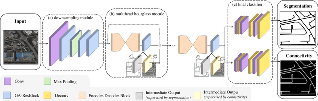
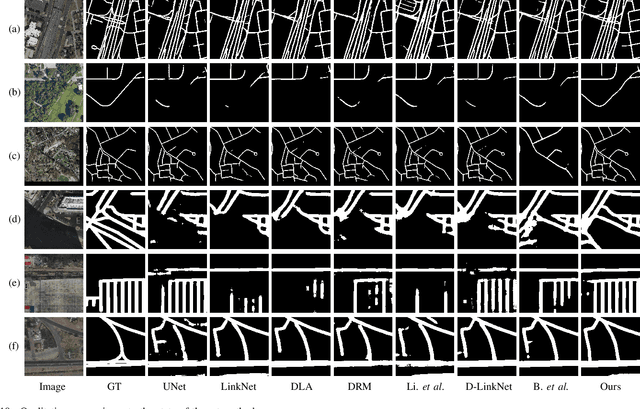
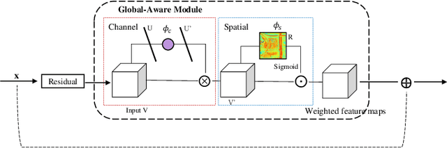
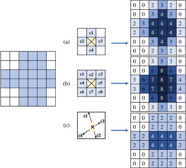
Road network extraction from satellite images is widely applicated in intelligent traffic management and autonomous driving fields. The high-resolution remote sensing images contain complex road areas and distracted background, which make it a challenge for road extraction. In this study, we present a stacked multitask network for end-to-end segmenting roads while preserving connectivity correctness. In the network, a global-aware module is introduced to enhance pixel-level road feature representation and eliminate background distraction from overhead images; a road-direction-related connectivity task is added to ensure that the network preserves the graph-level relationships of the road segments. We also develop a stacked multihead structure to jointly learn and effectively utilize the mutual information between connectivity learning and segmentation learning. We evaluate the performance of the proposed network on three public remote sensing datasets. The experimental results demonstrate that the network outperforms the state-of-the-art methods in terms of road segmentation accuracy and connectivity maintenance.