 Add to Chrome
 Add to Firefox
 Add to Edge
DamageArbiter: A CLIP-Enhanced Multimodal Arbitration Framework for Hurricane Damage Assessment from Street-View Imagery
Mar 16, 2026Analyzing street-view imagery with computer vision models for rapid, hyperlocal damage assessment is becoming popular and valuable in emergency response and recovery, but traditional models often act like black boxes, lacking interpretability and reliability. This study proposes a multimodal disagreement-driven Arbitration framework powered by Contrastive Language-Image Pre-training (CLIP) models, DamageArbiter, to improve the accuracy, interpretability, and robustness of damage estimation from street-view imagery. DamageArbiter leverages the complementary strengths of unimodal and multimodal models, employing a lightweight logistic regression meta-classifier to arbitrate cases of disagreement. Using 2,556 post-disaster street-view images, paired with both manually generated and large language model (LLM)-generated text descriptions, we systematically compared the performance of unimodal models (including image-only and text-only models), multimodal CLIP-based models, and DamageArbiter. Notably, DamageArbiter improved the accuracy from 74.33% (ViT-B/32, image-only) to 82.79%, surpassing the 80% accuracy threshold and achieving an absolute improvement of 8.46% compared to the strongest baseline model. Beyond improvements in overall accuracy, compared to visual models relying solely on images, DamageArbiter, through arbitration of discrepancies between unimodal and multimodal predictions, mitigates common overconfidence errors in visual models, especially in situations where disaster visual cues are ambiguous or subject to interference, reducing overconfidence but incorrect predictions. We further mapped and analyzed geo-referenced predictions and misclassifications to compare model performance across locations. Overall, this work advances street-view-based disaster assessment from coarse severity classification toward a more reliable and interpretable framework.
Daily Land Surface Temperature Reconstruction in Landsat Cross-Track Areas Using Deep Ensemble Learning With Uncertainty Quantification
Feb 20, 2025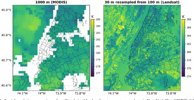
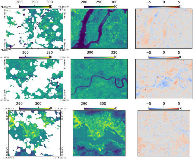
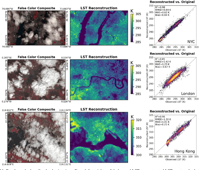
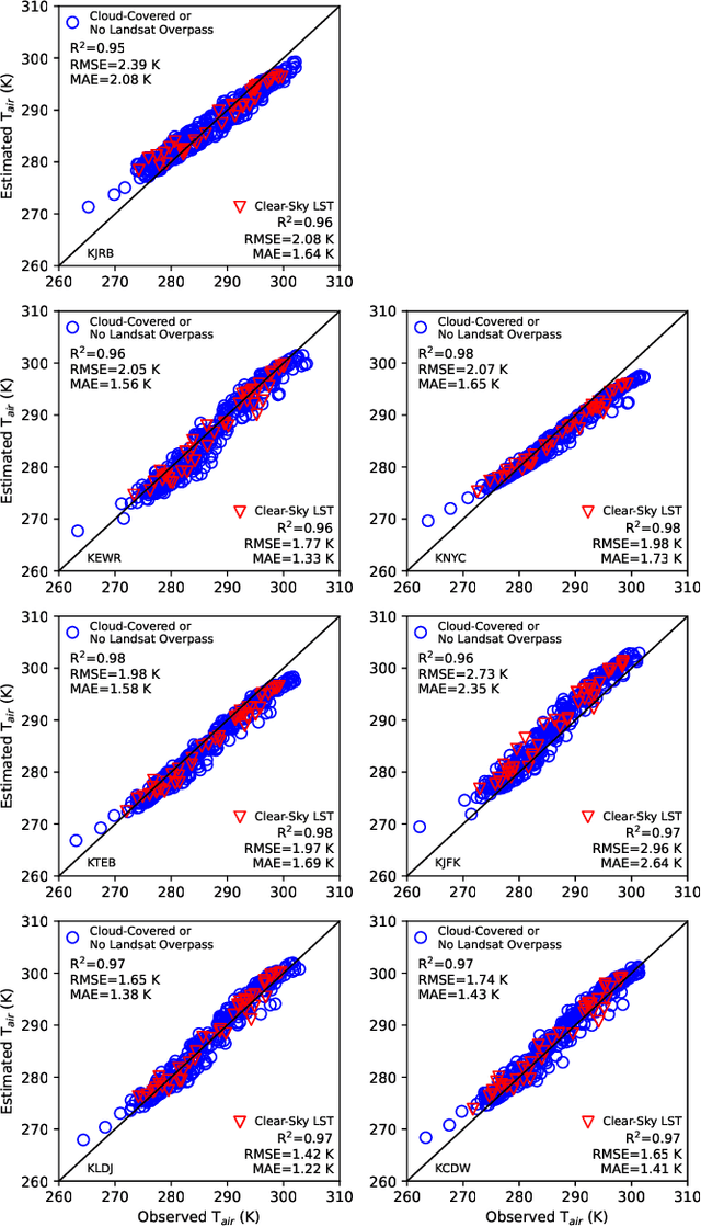
Many real-world applications rely on land surface temperature (LST) data at high spatiotemporal resolution. In complex urban areas, LST exhibits significant variations, fluctuating dramatically within and across city blocks. Landsat provides high spatial resolution data at 100 meters but is limited by long revisit time, with cloud cover further disrupting data collection. Here, we propose DELAG, a deep ensemble learning method that integrates annual temperature cycles and Gaussian processes, to reconstruct Landsat LST in complex urban areas. Leveraging the cross-track characteristics and dual-satellite operation of Landsat since 2021, we further enhance data availability to 4 scenes every 16 days. We select New York City, London and Hong Kong from three different continents as study areas. Experiments show that DELAG successfully reconstructed LST in the three cities under clear-sky (RMSE = 0.73-0.96 K) and heavily-cloudy (RMSE = 0.84-1.62 K) situations, superior to existing methods. Additionally, DELAG can quantify uncertainty that enhances LST reconstruction reliability. We further tested the reconstructed LST to estimate near-surface air temperature, achieving results (RMSE = 1.48-2.11 K) comparable to those derived from clear-sky LST (RMSE = 1.63-2.02 K). The results demonstrate the successful reconstruction through DELAG and highlight the broader applications of LST reconstruction for estimating accurate air temperature. Our study thus provides a novel and practical method for Landsat LST reconstruction, particularly suited for complex urban areas within Landsat cross-track areas, taking one step toward addressing complex climate events at high spatiotemporal resolution.
Navigating Spatial Inequities in Freight Truck Crash Severity via Counterfactual Inference in Los Angeles
Nov 26, 2024


Freight truck-related crashes pose significant challenges, leading to substantial economic losses, injuries, and fatalities, with pronounced spatial disparities across different regions. This study adopts a transport geography perspective to examine spatial justice concerns by employing deep counterfactual inference models to analyze how socioeconomic disparities, road infrastructure, and environmental conditions influence the geographical distribution and severity of freight truck crashes. By integrating road network datasets, socioeconomic attributes, and crash records from the Los Angeles metropolitan area, this research provides a nuanced spatial analysis of how different communities are disproportionately impacted. The results reveal significant spatial disparities in crash severity across areas with varying population densities, income levels, and minority populations, highlighting the pivotal role of infrastructural and environmental improvements in mitigating these disparities. The findings offer insights into targeted, location-specific policy interventions, suggesting enhancements in road infrastructure, lighting, and traffic control systems, particularly in low-income and minority-concentrated areas. This research contributes to the literature on transport geography and spatial equity by providing data-driven insights into effective measures for reducing spatial injustices associated with freight truck-related crashes.
StreetviewLLM: Extracting Geographic Information Using a Chain-of-Thought Multimodal Large Language Model
Nov 19, 2024


Geospatial predictions are crucial for diverse fields such as disaster management, urban planning, and public health. Traditional machine learning methods often face limitations when handling unstructured or multi-modal data like street view imagery. To address these challenges, we propose StreetViewLLM, a novel framework that integrates a large language model with the chain-of-thought reasoning and multimodal data sources. By combining street view imagery with geographic coordinates and textual data, StreetViewLLM improves the precision and granularity of geospatial predictions. Using retrieval-augmented generation techniques, our approach enhances geographic information extraction, enabling a detailed analysis of urban environments. The model has been applied to seven global cities, including Hong Kong, Tokyo, Singapore, Los Angeles, New York, London, and Paris, demonstrating superior performance in predicting urban indicators, including population density, accessibility to healthcare, normalized difference vegetation index, building height, and impervious surface. The results show that StreetViewLLM consistently outperforms baseline models, offering improved predictive accuracy and deeper insights into the built environment. This research opens new opportunities for integrating the large language model into urban analytics, decision-making in urban planning, infrastructure management, and environmental monitoring.