Natalia Efremova
Data-Driven Soil Organic Carbon Sampling: Integrating Spectral Clustering with Conditioned Latin Hypercube Optimization
Jun 12, 2025Abstract:Soil organic carbon (SOC) monitoring often relies on selecting representative field sampling locations based on environmental covariates. We propose a novel hybrid methodology that integrates spectral clustering - an unsupervised machine learning technique with conditioned Latin hypercube sampling (cLHS) to enhance the representativeness of SOC sampling. In our approach, spectral clustering partitions the study area into $K$ homogeneous zones using multivariate covariate data, and cLHS is then applied within each zone to select sampling locations that collectively capture the full diversity of environmental conditions. This hybrid spectral-cLHS method ensures that even minor but important environmental clusters are sampled, addressing a key limitation of vanilla cLHS which can overlook such areas. We demonstrate on a real SOC mapping dataset that spectral-cLHS provides more uniform coverage of covariate feature space and spatial heterogeneity than standard cLHS. This improved sampling design has the potential to yield more accurate SOC predictions by providing better-balanced training data for machine learning models.
Towards deployment-centric multimodal AI beyond vision and language
Apr 04, 2025Abstract:Multimodal artificial intelligence (AI) integrates diverse types of data via machine learning to improve understanding, prediction, and decision-making across disciplines such as healthcare, science, and engineering. However, most multimodal AI advances focus on models for vision and language data, while their deployability remains a key challenge. We advocate a deployment-centric workflow that incorporates deployment constraints early to reduce the likelihood of undeployable solutions, complementing data-centric and model-centric approaches. We also emphasise deeper integration across multiple levels of multimodality and multidisciplinary collaboration to significantly broaden the research scope beyond vision and language. To facilitate this approach, we identify common multimodal-AI-specific challenges shared across disciplines and examine three real-world use cases: pandemic response, self-driving car design, and climate change adaptation, drawing expertise from healthcare, social science, engineering, science, sustainability, and finance. By fostering multidisciplinary dialogue and open research practices, our community can accelerate deployment-centric development for broad societal impact.
Tukey g-and-h neural network regression for non-Gaussian data
Nov 12, 2024Abstract:This paper addresses non-Gaussian regression with neural networks via the use of the Tukey g-and-h distribution.The Tukey g-and-h transform is a flexible parametric transform with two parameters $g$ and $h$ which, when applied to a standard normal random variable, introduces both skewness and kurtosis, resulting in a distribution commonly called the Tukey g-and-h distribution. Specific values of $g$ and $h$ produce good approximations to other families of distributions, such as the Cauchy and student-t distributions. The flexibility of the Tukey g-and-h distribution has driven its popularity in the statistical community, in applied sciences and finance. In this work we consider the training of a neural network to predict the parameters of a Tukey g-and-h distribution in a regression framework via the minimization of the corresponding negative log-likelihood, despite the latter having no closed-form expression. We demonstrate the efficiency of our procedure in simulated examples and apply our method to a real-world dataset of global crop yield for several types of crops. Finally, we show how we can carry out a goodness-of-fit analysis between the predicted distributions and the test data. A Pytorch implementation is made available on Github and as a Pypi package.
Prediction of Sentinel-2 multi-band imagery with attention BiLSTM for continuous earth surface monitoring
Jun 30, 2024Abstract:Continuous monitoring of crops and forecasting crop conditions through time series analysis is crucial for effective agricultural management. This study proposes a framework based on an attention Bidirectional Long Short-Term Memory (BiLSTM) network for predicting multiband images. Our model can forecast target images on user-defined dates, including future dates and periods characterized by persistent cloud cover. By focusing on short sequences within a sequence-to-one forecasting framework, the model leverages advanced attention mechanisms to enhance prediction accuracy. Our experimental results demonstrate the model's superior performance in predicting NDVI, multiple vegetation indices, and all Sentinel-2 bands, highlighting its potential for improving remote sensing data continuity and reliability.
Soil nitrogen forecasting from environmental variables provided by multisensor remote sensing images
Jun 14, 2024Abstract:This study introduces a framework for forecasting soil nitrogen content, leveraging multi-modal data, including multi-sensor remote sensing images and advanced machine learning methods. We integrate the Land Use/Land Cover Area Frame Survey (LUCAS) database, which covers European and UK territory, with environmental variables from satellite sensors to create a dataset of novel features. We further test a broad range of machine learning algorithms, focusing on tree-based models such as CatBoost, LightGBM, and XGBoost. We test the proposed methods with a variety of land cover classes, including croplands and grasslands to ensure the robustness of this approach. Our results demonstrate that the CatBoost model surpasses other methods in accuracy. This research advances the field of agricultural management and environmental monitoring and demonstrates the significant potential of integrating multisensor remote sensing data with machine learning for environmental analysis.
Grapevine Disease Prediction Using Climate Variables from Multi-Sensor Remote Sensing Imagery via a Transformer Model
Jun 11, 2024Abstract:Early detection and management of grapevine diseases are important in pursuing sustainable viticulture. This paper introduces a novel framework leveraging the TabPFN model to forecast blockwise grapevine diseases using climate variables from multi-sensor remote sensing imagery. By integrating advanced machine learning techniques with detailed environmental data, our approach significantly enhances the accuracy and efficiency of disease prediction in vineyards. The TabPFN model's experimental evaluations showcase comparable performance to traditional gradient-boosted decision trees, such as XGBoost, CatBoost, and LightGBM. The model's capability to process complex data and provide per-pixel disease-affecting probabilities enables precise, targeted interventions, contributing to more sustainable disease management practices. Our findings underscore the transformative potential of combining Transformer models with remote sensing data in precision agriculture, offering a scalable solution for improving crop health and productivity while reducing environmental impact.
Soil Organic Carbon Estimation from Climate-related Features with Graph Neural Network
Nov 27, 2023Abstract:Soil organic carbon (SOC) plays a pivotal role in the global carbon cycle, impacting climate dynamics and necessitating accurate estimation for sustainable land and agricultural management. While traditional methods of SOC estimation face resolution and accuracy challenges, recent technological solutions harness remote sensing, machine learning, and high-resolution satellite mapping. Graph Neural Networks (GNNs), especially when integrated with positional encoders, can capture complex relationships between soil and climate. Using the LUCAS database, this study compared four GNN operators in the positional encoder framework. Results revealed that the PESAGE and PETransformer models outperformed others in SOC estimation, indicating their potential in capturing the complex relationship between SOC and climate features. Our findings confirm the feasibility of applications of GNN architectures in SOC prediction, establishing a framework for future explorations of this topic with more advanced GNN models.
AI for Agriculture: the Comparison of Semantic Segmentation Methods for Crop Mapping with Sentinel-2 Imagery
Nov 21, 2023Abstract:Crop mapping is one of the most common tasks in artificial intelligence for agriculture due to higher food demands from a growing population and increased awareness of climate change. In case of vineyards, the texture is very important for crop segmentation: with higher resolution satellite imagery the texture is easily detected by majority of state-of-the-art algorithms. However, this task becomes increasingly more difficult as the resolution of satellite imagery decreases and the information about the texture becomes unavailable. In this paper we aim to explore the main machine learning methods that can be used with freely available satellite imagery and discuss how and when they can be applied for vineyard segmentation problem. We assess the effectiveness of various widely-used machine learning techniques and offer guidance on selecting the most suitable model for specific scenarios.
Optimal Use of Multi-spectral Satellite Data with Convolutional Neural Networks
Sep 15, 2020


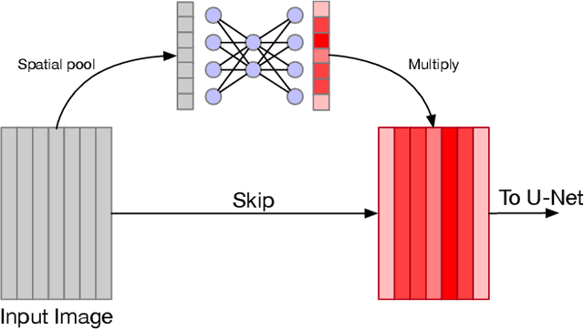
Abstract:The analysis of satellite imagery will prove a crucial tool in the pursuit of sustainable development. While Convolutional Neural Networks (CNNs) have made large gains in natural image analysis, their application to multi-spectral satellite images (wherein input images have a large number of channels) remains relatively unexplored. In this paper, we compare different methods of leveraging multi-band information with CNNs, demonstrating the performance of all compared methods on the task of semantic segmentation of agricultural vegetation (vineyards). We show that standard industry practice of using bands selected by a domain expert leads to a significantly worse test accuracy than the other methods compared. Specifically, we compare: using bands specified by an expert; using all available bands; learning attention maps over the input bands; and leveraging Bayesian optimisation to dictate band choice. We show that simply using all available band information already increases test time performance, and show that the Bayesian optimisation, first applied to band selection in this work, can be used to further boost accuracy.
SMArtCast: Predicting soil moisture interpolations into the future using Earth observation data in a deep learning framework
Mar 16, 2020


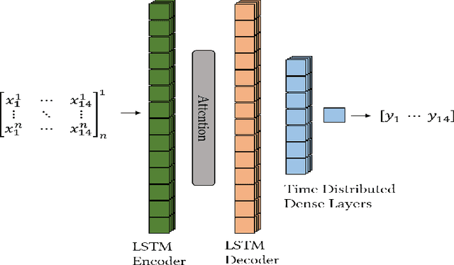
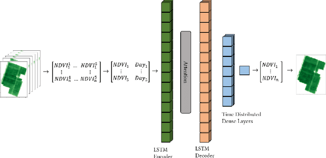
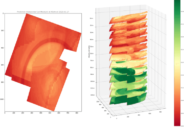
Abstract:Soil moisture is critical component of crop health and monitoring it can enable further actions for increasing yield or preventing catastrophic die off. As climate change increases the likelihood of extreme weather events and reduces the predictability of weather, and non-optimal soil moistures for crops may become more likely. In this work, we a series of LSTM architectures to analyze measurements of soil moisture and vegetation indiced derived from satellite imagery. The system learns to predict the future values of these measurements. These spatially sparse values and indices are used as input features to an interpolation method that infer spatially dense moisture map for a future time point. This has the potential to provide advance warning for soil moistures that may be inhospitable to crops across an area with limited monitoring capacity.
 Add to Chrome
 Add to Firefox
 Add to Edge