 Add to Chrome
 Add to Firefox
 Add to Edge
One Channel to Rule Them All: Rethinking Input Representation for Visual Place Recognition
May 31, 2026Visual Place Recognition (VPR) is fundamental to long-term robot localization and SLAM, yet current systems overwhelmingly rely on RGB input, implicitly assuming color is necessary for global place recognition. We challenge this assumption, investigating the role of chromatic information across training regimes, model architectures and standard benchmarks under real-world appearance variation. We find that grayscale matches RGB performance generally and outperforms it under severe appearance shifts where color invariance is insufficiently learned, while color provides meaningful gains only where persistent and discriminative chromatic cues are present. Across selected benchmarks, a fully gray-trained MixVPR model achieves an average 82.4% Recall@1 compared to 81.2% for its RGB counterpart. In some cases, lightweight grayscale variants with 60% fewer parameters can outperform heavier RGB models. Grayscale further offers practical advantages in storage, bandwidth and alignment with resource-constrained systems. We conclude that for global VPR where scenes vary across illumination, weather, season and setting, color contributes minimally, and grayscale alone is sufficient for reliable place recognition.
DisPlace: Discriminative Place Projections for Multi-Reference Visual Place Recognition
May 29, 2026A key challenge in Visual Place Recognition (VPR) is matching query images against reference maps captured under diverse environmental conditions and viewpoints. While multiple reference traversals improve robustness, existing fusion strategies either aggregate references uniformly or rely on heuristic selection, without distinguishing descriptor variations that preserve stable place identity from those caused by changing conditions or viewpoints. In this paper, we propose DisPlace, a multi-reference VPR framework that fuses multiple reference descriptors into a single compact and discriminative place representation. DisPlace formulates descriptor fusion as a generalized eigenvalue problem that maximizes between-place separability while suppressing within-place variation across references, rather than preserving overall descriptor variance. Unlike existing multi-reference fusion methods, DisPlace exploits variation across reference traversals to identify which linear combinations of descriptor dimensions preserve place identity and which capture condition- or viewpoint-specific variation. We evaluate DisPlace on Oxford RobotCar, Nordland, Pittsburgh30k, and Google Landmarks v2 across six state-of-the-art VPR descriptors. DisPlace outperforms seven multi-reference baselines in 49 out of 54 appearance-varying conditions, consistently improves descriptor-level fusion performance under viewpoint and unstructured settings, and requires less storage during inference than all compared fusion methods.
Automatic Map Density Selection for Locally-Performant Visual Place Recognition
Feb 25, 2026A key challenge in translating Visual Place Recognition (VPR) from the lab to long-term deployment is ensuring a priori that a system can meet user-specified performance requirements across different parts of an environment, rather than just on average globally. A critical mechanism for controlling local VPR performance is the density of the reference mapping database, yet this factor is largely neglected in existing work, where benchmark datasets with fixed, engineering-driven (sensors, storage, GPS frequency) sampling densities are typically used. In this paper, we propose a dynamic VPR mapping approach that uses pairs of reference traverses from the target environment to automatically select an appropriate map density to satisfy two user-defined requirements: (1) a target Local Recall@1 level, and (2) the proportion of the operational environment over which this requirement must be met or exceeded, which we term the Recall Achievement Rate (RAR). Our approach is based on the hypothesis that match patterns between multiple reference traverses, evaluated across different map densities, can be modelled to predict the density required to meet these performance targets on unseen deployment data. Through extensive experiments across multiple VPR methods and the Nordland and Oxford RobotCar benchmarks, we show that our system consistently achieves or exceeds the specified local recall level over at least the user-specified proportion of the environment. Comparisons with alternative baselines demonstrate that our approach reliably selects the correct operating point in map density, avoiding unnecessary over-densification. Finally, ablation studies and analysis evaluate sensitivity to reference map choice and local space definitions, and reveal that conventional global Recall@1 is a poor predictor of the often more operationally meaningful RAR metric.
Long-Term Multi-Session 3D Reconstruction Under Substantial Appearance Change
Feb 24, 2026Long-term environmental monitoring requires the ability to reconstruct and align 3D models across repeated site visits separated by months or years. However, existing Structure-from-Motion (SfM) pipelines implicitly assume near-simultaneous image capture and limited appearance change, and therefore fail when applied to long-term monitoring scenarios such as coral reef surveys, where substantial visual and structural change is common. In this paper, we show that the primary limitation of current approaches lies in their reliance on post-hoc alignment of independently reconstructed sessions, which is insufficient under large temporal appearance change. We address this limitation by enforcing cross-session correspondences directly within a joint SfM reconstruction. Our approach combines complementary handcrafted and learned visual features to robustly establish correspondences across large temporal gaps, enabling the reconstruction of a single coherent 3D model from imagery captured years apart, where standard independent and joint SfM pipelines break down. We evaluate our method on long-term coral reef datasets exhibiting significant real-world change, and demonstrate consistent joint reconstruction across sessions in cases where existing methods fail to produce coherent reconstructions. To ensure scalability to large datasets, we further restrict expensive learned feature matching to a small set of likely cross-session image pairs identified via visual place recognition, which reduces computational cost and improves alignment robustness.
Quantile Transfer for Reliable Operating Point Selection in Visual Place Recognition
Feb 04, 2026Visual Place Recognition (VPR) is a key component for localisation in GNSS-denied environments, but its performance critically depends on selecting an image matching threshold (operating point) that balances precision and recall. Thresholds are typically hand-tuned offline for a specific environment and fixed during deployment, leading to degraded performance under environmental change. We propose a method that, given a user-defined precision requirement, automatically selects the operating point of a VPR system to maximise recall. The method uses a small calibration traversal with known correspondences and transfers thresholds to deployment via quantile normalisation of similarity score distributions. This quantile transfer ensures that thresholds remain stable across calibration sizes and query subsets, making the method robust to sampling variability. Experiments with multiple state-of-the-art VPR techniques and datasets show that the proposed approach consistently outperforms the state-of-the-art, delivering up to 25% higher recall in high-precision operating regimes. The method eliminates manual tuning by adapting to new environments and generalising across operating conditions. Our code will be released upon acceptance.
Robust Scene Coordinate Regression via Geometrically-Consistent Global Descriptors
Dec 19, 2025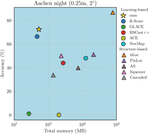
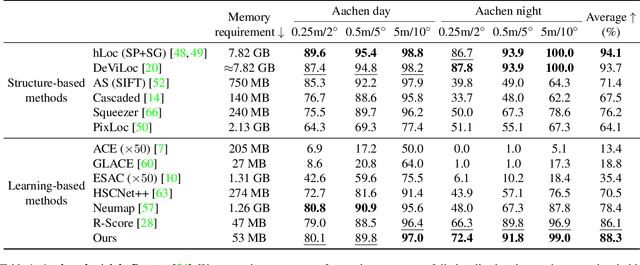
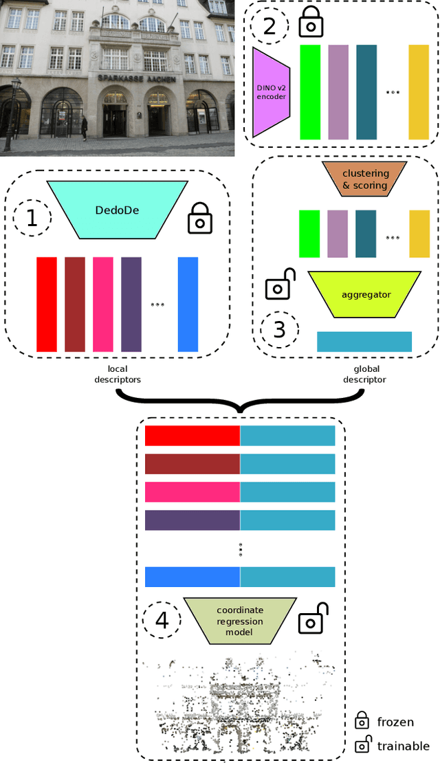
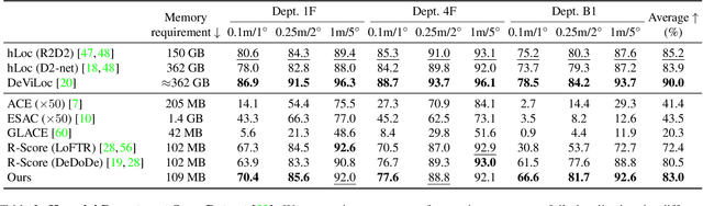
Recent learning-based visual localization methods use global descriptors to disambiguate visually similar places, but existing approaches often derive these descriptors from geometric cues alone (e.g., covisibility graphs), limiting their discriminative power and reducing robustness in the presence of noisy geometric constraints. We propose an aggregator module that learns global descriptors consistent with both geometrical structure and visual similarity, ensuring that images are close in descriptor space only when they are visually similar and spatially connected. This corrects erroneous associations caused by unreliable overlap scores. Using a batch-mining strategy based solely on the overlap scores and a modified contrastive loss, our method trains without manual place labels and generalizes across diverse environments. Experiments on challenging benchmarks show substantial localization gains in large-scale environments while preserving computational and memory efficiency. Code is available at \href{https://github.com/sontung/robust\_scr}{github.com/sontung/robust\_scr}.
Going Places: Place Recognition in Artificial and Natural Systems
Nov 18, 2025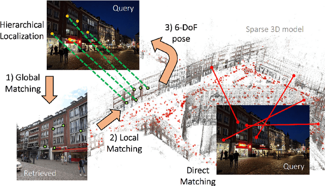
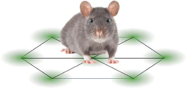
Place recognition, the ability to identify previously visited locations, is critical for both biological navigation and autonomous systems. This review synthesizes findings from robotic systems, animal studies, and human research to explore how different systems encode and recall place. We examine the computational and representational strategies employed across artificial systems, animals, and humans, highlighting convergent solutions such as topological mapping, cue integration, and memory management. Animal systems reveal evolved mechanisms for multimodal navigation and environmental adaptation, while human studies provide unique insights into semantic place concepts, cultural influences, and introspective capabilities. Artificial systems showcase scalable architectures and data-driven models. We propose a unifying set of concepts by which to consider and develop place recognition mechanisms and identify key challenges such as generalization, robustness, and environmental variability. This review aims to foster innovations in artificial localization by connecting future developments in artificial place recognition systems to insights from both animal navigation research and human spatial cognition studies.
Pixi: Unified Software Development and Distribution for Robotics and AI
Nov 06, 2025The reproducibility crisis in scientific computing constrains robotics research. Existing studies reveal that up to 70% of robotics algorithms cannot be reproduced by independent teams, while many others fail to reach deployment because creating shareable software environments remains prohibitively complex. These challenges stem from fragmented, multi-language, and hardware-software toolchains that lead to dependency hell. We present Pixi, a unified package-management framework that addresses these issues by capturing exact dependency states in project-level lockfiles, ensuring bit-for-bit reproducibility across platforms. Its high-performance SAT solver achieves up to 10x faster dependency resolution than comparable tools, while integration of the conda-forge and PyPI ecosystems removes the need for multiple managers. Adopted in over 5,300 projects since 2023, Pixi reduces setup times from hours to minutes and lowers technical barriers for researchers worldwide. By enabling scalable, reproducible, collaborative research infrastructure, Pixi accelerates progress in robotics and AI.
Event-LAB: Towards Standardized Evaluation of Neuromorphic Localization Methods
Sep 18, 2025Event-based localization research and datasets are a rapidly growing area of interest, with a tenfold increase in the cumulative total number of published papers on this topic over the past 10 years. Whilst the rapid expansion in the field is exciting, it brings with it an associated challenge: a growth in the variety of required code and package dependencies as well as data formats, making comparisons difficult and cumbersome for researchers to implement reliably. To address this challenge, we present Event-LAB: a new and unified framework for running several event-based localization methodologies across multiple datasets. Event-LAB is implemented using the Pixi package and dependency manager, that enables a single command-line installation and invocation for combinations of localization methods and datasets. To demonstrate the capabilities of the framework, we implement two common event-based localization pipelines: Visual Place Recognition (VPR) and Simultaneous Localization and Mapping (SLAM). We demonstrate the ability of the framework to systematically visualize and analyze the results of multiple methods and datasets, revealing key insights such as the association of parameters that control event collection counts and window sizes for frame generation to large variations in performance. The results and analysis demonstrate the importance of fairly comparing methodologies with consistent event image generation parameters. Our Event-LAB framework provides this ability for the research community, by contributing a streamlined workflow for easily setting up multiple conditions.
Assessing the Geolocation Capabilities, Limitations and Societal Risks of Generative Vision-Language Models
Aug 27, 2025Geo-localization is the task of identifying the location of an image using visual cues alone. It has beneficial applications, such as improving disaster response, enhancing navigation, and geography education. Recently, Vision-Language Models (VLMs) are increasingly demonstrating capabilities as accurate image geo-locators. This brings significant privacy risks, including those related to stalking and surveillance, considering the widespread uses of AI models and sharing of photos on social media. The precision of these models is likely to improve in the future. Despite these risks, there is little work on systematically evaluating the geolocation precision of Generative VLMs, their limits and potential for unintended inferences. To bridge this gap, we conduct a comprehensive assessment of the geolocation capabilities of 25 state-of-the-art VLMs on four benchmark image datasets captured in diverse environments. Our results offer insight into the internal reasoning of VLMs and highlight their strengths, limitations, and potential societal risks. Our findings indicate that current VLMs perform poorly on generic street-level images yet achieve notably high accuracy (61\%) on images resembling social media content, raising significant and urgent privacy concerns.