Mathieu Aubry
Segmenting France Across Four Centuries
May 30, 2025Abstract:Historical maps offer an invaluable perspective into territory evolution across past centuries--long before satellite or remote sensing technologies existed. Deep learning methods have shown promising results in segmenting historical maps, but publicly available datasets typically focus on a single map type or period, require extensive and costly annotations, and are not suited for nationwide, long-term analyses. In this paper, we introduce a new dataset of historical maps tailored for analyzing large-scale, long-term land use and land cover evolution with limited annotations. Spanning metropolitan France (548,305 km^2), our dataset contains three map collections from the 18th, 19th, and 20th centuries. We provide both comprehensive modern labels and 22,878 km^2 of manually annotated historical labels for the 18th and 19th century maps. Our dataset illustrates the complexity of the segmentation task, featuring stylistic inconsistencies, interpretive ambiguities, and significant landscape changes (e.g., marshlands disappearing in favor of forests). We assess the difficulty of these challenges by benchmarking three approaches: a fully-supervised model trained with historical labels, and two weakly-supervised models that rely only on modern annotations. The latter either use the modern labels directly or first perform image-to-image translation to address the stylistic gap between historical and contemporary maps. Finally, we discuss how these methods can support long-term environment monitoring, offering insights into centuries of landscape transformation. Our official project repository is publicly available at https://github.com/Archiel19/FRAx4.git.
CoDEx: Combining Domain Expertise for Spatial Generalization in Satellite Image Analysis
Apr 28, 2025Abstract:Global variations in terrain appearance raise a major challenge for satellite image analysis, leading to poor model performance when training on locations that differ from those encountered at test time. This remains true even with recent large global datasets. To address this challenge, we propose a novel domain-generalization framework for satellite images. Instead of trying to learn a single generalizable model, we train one expert model per training domain, while learning experts' similarity and encouraging similar experts to be consistent. A model selection module then identifies the most suitable experts for a given test sample and aggregates their predictions. Experiments on four datasets (DynamicEarthNet, MUDS, OSCD, and FMoW) demonstrate consistent gains over existing domain generalization and adaptation methods. Our code is publicly available at https://github.com/Abhishek19009/CoDEx.
General Detection-based Text Line Recognition
Sep 25, 2024


Abstract:We introduce a general detection-based approach to text line recognition, be it printed (OCR) or handwritten (HTR), with Latin, Chinese, or ciphered characters. Detection-based approaches have until now been largely discarded for HTR because reading characters separately is often challenging, and character-level annotation is difficult and expensive. We overcome these challenges thanks to three main insights: (i) synthetic pre-training with sufficiently diverse data enables learning reasonable character localization for any script; (ii) modern transformer-based detectors can jointly detect a large number of instances, and, if trained with an adequate masking strategy, leverage consistency between the different detections; (iii) once a pre-trained detection model with approximate character localization is available, it is possible to fine-tune it with line-level annotation on real data, even with a different alphabet. Our approach, dubbed DTLR, builds on a completely different paradigm than state-of-the-art HTR methods, which rely on autoregressive decoding, predicting character values one by one, while we treat a complete line in parallel. Remarkably, we demonstrate good performance on a large range of scripts, usually tackled with specialized approaches. In particular, we improve state-of-the-art performances for Chinese script recognition on the CASIA v2 dataset, and for cipher recognition on the Borg and Copiale datasets. Our code and models are available at https://github.com/raphael-baena/DTLR.
Detecting Looted Archaeological Sites from Satellite Image Time Series
Sep 14, 2024


Abstract:Archaeological sites are the physical remains of past human activity and one of the main sources of information about past societies and cultures. However, they are also the target of malevolent human actions, especially in countries having experienced inner turmoil and conflicts. Because monitoring these sites from space is a key step towards their preservation, we introduce the DAFA Looted Sites dataset, \datasetname, a labeled multi-temporal remote sensing dataset containing 55,480 images acquired monthly over 8 years across 675 Afghan archaeological sites, including 135 sites looted during the acquisition period. \datasetname~is particularly challenging because of the limited number of training samples, the class imbalance, the weak binary annotations only available at the level of the time series, and the subtlety of relevant changes coupled with important irrelevant ones over a long time period. It is also an interesting playground to assess the performance of satellite image time series (SITS) classification methods on a real and important use case. We evaluate a large set of baselines, outline the substantial benefits of using foundation models and show the additional boost that can be provided by using complete time series instead of using a single image.
Historical Printed Ornaments: Dataset and Tasks
Aug 16, 2024Abstract:This paper aims to develop the study of historical printed ornaments with modern unsupervised computer vision. We highlight three complex tasks that are of critical interest to book historians: clustering, element discovery, and unsupervised change localization. For each of these tasks, we introduce an evaluation benchmark, and we adapt and evaluate state-of-the-art models. Our Rey's Ornaments dataset is designed to be a representative example of a set of ornaments historians would be interested in. It focuses on an XVIIIth century bookseller, Marc-Michel Rey, providing a consistent set of ornaments with a wide diversity and representative challenges. Our results highlight the limitations of state-of-the-art models when faced with real data and show simple baselines such as k-means or congealing can outperform more sophisticated approaches on such data. Our dataset and code can be found at https://printed-ornaments.github.io/.
Diffusion Models as Data Mining Tools
Jul 20, 2024Abstract:This paper demonstrates how to use generative models trained for image synthesis as tools for visual data mining. Our insight is that since contemporary generative models learn an accurate representation of their training data, we can use them to summarize the data by mining for visual patterns. Concretely, we show that after finetuning conditional diffusion models to synthesize images from a specific dataset, we can use these models to define a typicality measure on that dataset. This measure assesses how typical visual elements are for different data labels, such as geographic location, time stamps, semantic labels, or even the presence of a disease. This analysis-by-synthesis approach to data mining has two key advantages. First, it scales much better than traditional correspondence-based approaches since it does not require explicitly comparing all pairs of visual elements. Second, while most previous works on visual data mining focus on a single dataset, our approach works on diverse datasets in terms of content and scale, including a historical car dataset, a historical face dataset, a large worldwide street-view dataset, and an even larger scene dataset. Furthermore, our approach allows for translating visual elements across class labels and analyzing consistent changes.
Satellite Image Time Series Semantic Change Detection: Novel Architecture and Analysis of Domain Shift
Jul 10, 2024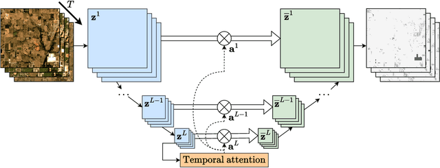
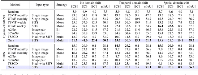
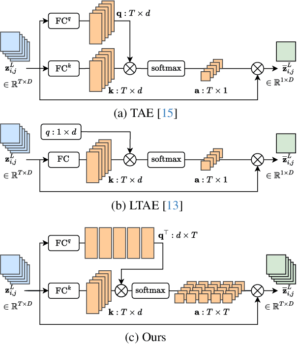
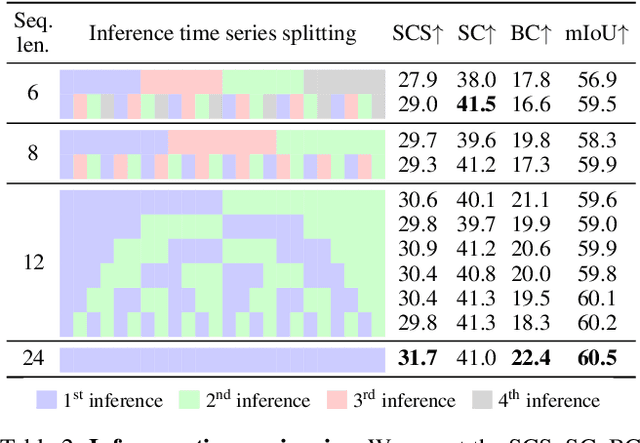
Abstract:Satellite imagery plays a crucial role in monitoring changes happening on Earth's surface and aiding in climate analysis, ecosystem assessment, and disaster response. In this paper, we tackle semantic change detection with satellite image time series (SITS-SCD) which encompasses both change detection and semantic segmentation tasks. We propose a new architecture that improves over the state of the art, scales better with the number of parameters, and leverages long-term temporal information. However, for practical use cases, models need to adapt to spatial and temporal shifts, which remains a challenge. We investigate the impact of temporal and spatial shifts separately on global, multi-year SITS datasets using DynamicEarthNet and MUDS. We show that the spatial domain shift represents the most complex setting and that the impact of temporal shift on performance is more pronounced on change detection than on semantic segmentation, highlighting that it is a specific issue deserving further attention.
Historical Astronomical Diagrams Decomposition in Geometric Primitives
Mar 13, 2024


Abstract:Automatically extracting the geometric content from the hundreds of thousands of diagrams drawn in historical manuscripts would enable historians to study the diffusion of astronomical knowledge on a global scale. However, state-of-the-art vectorization methods, often designed to tackle modern data, are not adapted to the complexity and diversity of historical astronomical diagrams. Our contribution is thus twofold. First, we introduce a unique dataset of 303 astronomical diagrams from diverse traditions, ranging from the XIIth to the XVIIIth century, annotated with more than 3000 line segments, circles and arcs. Second, we develop a model that builds on DINO-DETR to enable the prediction of multiple geometric primitives. We show that it can be trained solely on synthetic data and accurately predict primitives on our challenging dataset. Our approach widely improves over the LETR baseline, which is restricted to lines, by introducing a meaningful parametrization for multiple primitives, jointly training for detection and parameter refinement, using deformable attention and training on rich synthetic data. Our dataset and code are available on our webpage.
Differentiable Blocks World: Qualitative 3D Decomposition by Rendering Primitives
Jul 11, 2023


Abstract:Given a set of calibrated images of a scene, we present an approach that produces a simple, compact, and actionable 3D world representation by means of 3D primitives. While many approaches focus on recovering high-fidelity 3D scenes, we focus on parsing a scene into mid-level 3D representations made of a small set of textured primitives. Such representations are interpretable, easy to manipulate and suited for physics-based simulations. Moreover, unlike existing primitive decomposition methods that rely on 3D input data, our approach operates directly on images through differentiable rendering. Specifically, we model primitives as textured superquadric meshes and optimize their parameters from scratch with an image rendering loss. We highlight the importance of modeling transparency for each primitive, which is critical for optimization and also enables handling varying numbers of primitives. We show that the resulting textured primitives faithfully reconstruct the input images and accurately model the visible 3D points, while providing amodal shape completions of unseen object regions. We compare our approach to the state of the art on diverse scenes from DTU, and demonstrate its robustness on real-life captures from BlendedMVS and Nerfstudio. We also showcase how our results can be used to effortlessly edit a scene or perform physical simulations. Code and video results are available at https://www.tmonnier.com/DBW .
Learnable Earth Parser: Discovering 3D Prototypes in Aerial Scans
Apr 19, 2023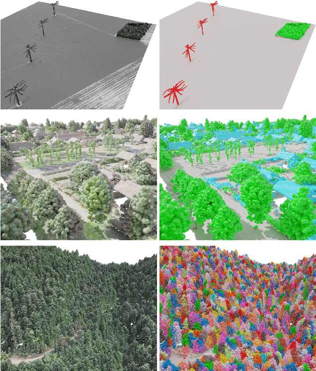
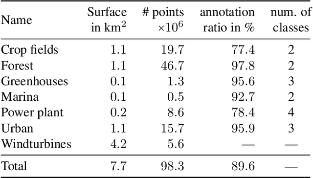


Abstract:We propose an unsupervised method for parsing large 3D scans of real-world scenes into interpretable parts. Our goal is to provide a practical tool for analyzing 3D scenes with unique characteristics in the context of aerial surveying and mapping, without relying on application-specific user annotations. Our approach is based on a probabilistic reconstruction model that decomposes an input 3D point cloud into a small set of learned prototypical shapes. Our model provides an interpretable reconstruction of complex scenes and leads to relevant instance and semantic segmentations. To demonstrate the usefulness of our results, we introduce a novel dataset of seven diverse aerial LiDAR scans. We show that our method outperforms state-of-the-art unsupervised methods in terms of decomposition accuracy while remaining visually interpretable. Our method offers significant advantage over existing approaches, as it does not require any manual annotations, making it a practical and efficient tool for 3D scene analysis. Our code and dataset are available at https://imagine.enpc.fr/~loiseaur/learnable-earth-parser
 Add to Chrome
 Add to Firefox
 Add to Edge