M Ashraful Amin
Center for Computational & Data Sciences, Independent University, Bangladesh
BAPPA: Benchmarking Agents, Plans, and Pipelines for Automated Text-to-SQL Generation
Nov 06, 2025


Abstract:Text-to-SQL systems provide a natural language interface that can enable even laymen to access information stored in databases. However, existing Large Language Models (LLM) struggle with SQL generation from natural instructions due to large schema sizes and complex reasoning. Prior work often focuses on complex, somewhat impractical pipelines using flagship models, while smaller, efficient models remain overlooked. In this work, we explore three multi-agent LLM pipelines, with systematic performance benchmarking across a range of small to large open-source models: (1) Multi-agent discussion pipeline, where agents iteratively critique and refine SQL queries, and a judge synthesizes the final answer; (2) Planner-Coder pipeline, where a thinking model planner generates stepwise SQL generation plans and a coder synthesizes queries; and (3) Coder-Aggregator pipeline, where multiple coders independently generate SQL queries, and a reasoning agent selects the best query. Experiments on the Bird-Bench Mini-Dev set reveal that Multi-Agent discussion can improve small model performance, with up to 10.6% increase in Execution Accuracy for Qwen2.5-7b-Instruct seen after three rounds of discussion. Among the pipelines, the LLM Reasoner-Coder pipeline yields the best results, with DeepSeek-R1-32B and QwQ-32B planners boosting Gemma 3 27B IT accuracy from 52.4% to the highest score of 56.4%. Codes are available at https://github.com/treeDweller98/bappa-sql.
FedCTTA: A Collaborative Approach to Continual Test-Time Adaptation in Federated Learning
May 19, 2025Abstract:Federated Learning (FL) enables collaborative model training across distributed clients without sharing raw data, making it ideal for privacy-sensitive applications. However, FL models often suffer performance degradation due to distribution shifts between training and deployment. Test-Time Adaptation (TTA) offers a promising solution by allowing models to adapt using only test samples. However, existing TTA methods in FL face challenges such as computational overhead, privacy risks from feature sharing, and scalability concerns due to memory constraints. To address these limitations, we propose Federated Continual Test-Time Adaptation (FedCTTA), a privacy-preserving and computationally efficient framework for federated adaptation. Unlike prior methods that rely on sharing local feature statistics, FedCTTA avoids direct feature exchange by leveraging similarity-aware aggregation based on model output distributions over randomly generated noise samples. This approach ensures adaptive knowledge sharing while preserving data privacy. Furthermore, FedCTTA minimizes the entropy at each client for continual adaptation, enhancing the model's confidence in evolving target distributions. Our method eliminates the need for server-side training during adaptation and maintains a constant memory footprint, making it scalable even as the number of clients or training rounds increases. Extensive experiments show that FedCTTA surpasses existing methods across diverse temporal and spatial heterogeneity scenarios.
DM-Codec: Distilling Multimodal Representations for Speech Tokenization
Oct 19, 2024


Abstract:Recent advancements in speech-language models have yielded significant improvements in speech tokenization and synthesis. However, effectively mapping the complex, multidimensional attributes of speech into discrete tokens remains challenging. This process demands acoustic, semantic, and contextual information for precise speech representations. Existing speech representations generally fall into two categories: acoustic tokens from audio codecs and semantic tokens from speech self-supervised learning models. Although recent efforts have unified acoustic and semantic tokens for improved performance, they overlook the crucial role of contextual representation in comprehensive speech modeling. Our empirical investigations reveal that the absence of contextual representations results in elevated Word Error Rate (WER) and Word Information Lost (WIL) scores in speech transcriptions. To address these limitations, we propose two novel distillation approaches: (1) a language model (LM)-guided distillation method that incorporates contextual information, and (2) a combined LM and self-supervised speech model (SM)-guided distillation technique that effectively distills multimodal representations (acoustic, semantic, and contextual) into a comprehensive speech tokenizer, termed DM-Codec. The DM-Codec architecture adopts a streamlined encoder-decoder framework with a Residual Vector Quantizer (RVQ) and incorporates the LM and SM during the training process. Experiments show DM-Codec significantly outperforms state-of-the-art speech tokenization models, reducing WER by up to 13.46%, WIL by 9.82%, and improving speech quality by 5.84% and intelligibility by 1.85% on the LibriSpeech benchmark dataset. The code, samples, and model checkpoints are available at https://github.com/mubtasimahasan/DM-Codec.
BD-SAT: High-resolution Land Use Land Cover Dataset & Benchmark Results for Developing Division: Dhaka, BD
Jun 09, 2024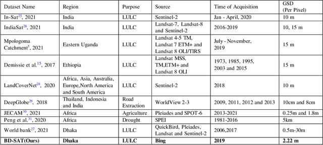
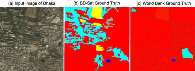
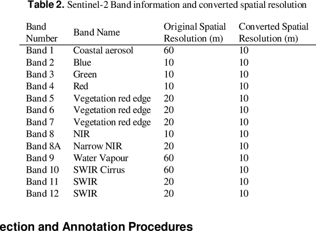
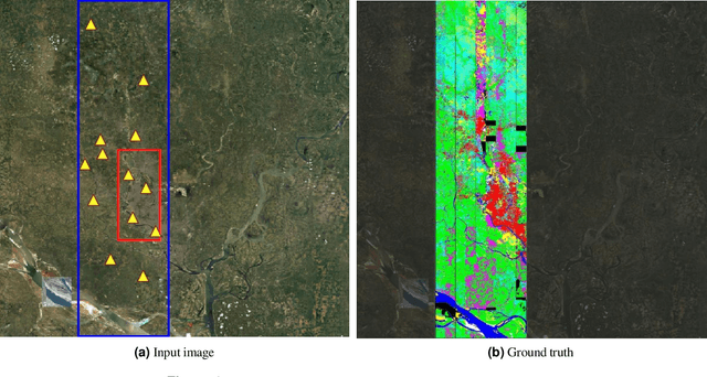
Abstract:Land Use Land Cover (LULC) analysis on satellite images using deep learning-based methods is significantly helpful in understanding the geography, socio-economic conditions, poverty levels, and urban sprawl in developing countries. Recent works involve segmentation with LULC classes such as farmland, built-up areas, forests, meadows, water bodies, etc. Training deep learning methods on satellite images requires large sets of images annotated with LULC classes. However, annotated data for developing countries are scarce due to a lack of funding, absence of dedicated residential/industrial/economic zones, a large population, and diverse building materials. BD-SAT provides a high-resolution dataset that includes pixel-by-pixel LULC annotations for Dhaka metropolitan city and surrounding rural/urban areas. Using a strict and standardized procedure, the ground truth is created using Bing satellite imagery with a ground spatial distance of 2.22 meters per pixel. A three-stage, well-defined annotation process has been followed with support from GIS experts to ensure the reliability of the annotations. We performed several experiments to establish benchmark results. The results show that the annotated BD-SAT is sufficient to train large deep learning models with adequate accuracy for five major LULC classes: forest, farmland, built-up areas, water bodies, and meadows.
Morphological Classification of Radio Galaxies using Semi-Supervised Group Equivariant CNNs
May 31, 2023Abstract:Out of the estimated few trillion galaxies, only around a million have been detected through radio frequencies, and only a tiny fraction, approximately a thousand, have been manually classified. We have addressed this disparity between labeled and unlabeled images of radio galaxies by employing a semi-supervised learning approach to classify them into the known Fanaroff-Riley Type I (FRI) and Type II (FRII) categories. A Group Equivariant Convolutional Neural Network (G-CNN) was used as an encoder of the state-of-the-art self-supervised methods SimCLR (A Simple Framework for Contrastive Learning of Visual Representations) and BYOL (Bootstrap Your Own Latent). The G-CNN preserves the equivariance for the Euclidean Group E(2), enabling it to effectively learn the representation of globally oriented feature maps. After representation learning, we trained a fully-connected classifier and fine-tuned the trained encoder with labeled data. Our findings demonstrate that our semi-supervised approach outperforms existing state-of-the-art methods across several metrics, including cluster quality, convergence rate, accuracy, precision, recall, and the F1-score. Moreover, statistical significance testing via a t-test revealed that our method surpasses the performance of a fully supervised G-CNN. This study emphasizes the importance of semi-supervised learning in radio galaxy classification, where labeled data are still scarce, but the prospects for discovery are immense.
Variational Stacked Local Attention Networks for Diverse Video Captioning
Jan 04, 2022

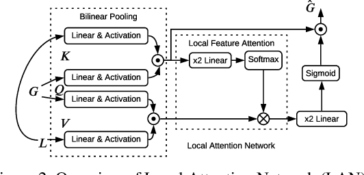
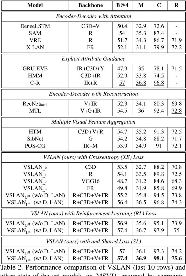
Abstract:While describing Spatio-temporal events in natural language, video captioning models mostly rely on the encoder's latent visual representation. Recent progress on the encoder-decoder model attends encoder features mainly in linear interaction with the decoder. However, growing model complexity for visual data encourages more explicit feature interaction for fine-grained information, which is currently absent in the video captioning domain. Moreover, feature aggregations methods have been used to unveil richer visual representation, either by the concatenation or using a linear layer. Though feature sets for a video semantically overlap to some extent, these approaches result in objective mismatch and feature redundancy. In addition, diversity in captions is a fundamental component of expressing one event from several meaningful perspectives, currently missing in the temporal, i.e., video captioning domain. To this end, we propose Variational Stacked Local Attention Network (VSLAN), which exploits low-rank bilinear pooling for self-attentive feature interaction and stacking multiple video feature streams in a discount fashion. Each feature stack's learned attributes contribute to our proposed diversity encoding module, followed by the decoding query stage to facilitate end-to-end diverse and natural captions without any explicit supervision on attributes. We evaluate VSLAN on MSVD and MSR-VTT datasets in terms of syntax and diversity. The CIDEr score of VSLAN outperforms current off-the-shelf methods by $7.8\%$ on MSVD and $4.5\%$ on MSR-VTT, respectively. On the same datasets, VSLAN achieves competitive results in caption diversity metrics.
Unified Spatio-Temporal Modeling for Traffic Forecasting using Graph Neural Network
Apr 28, 2021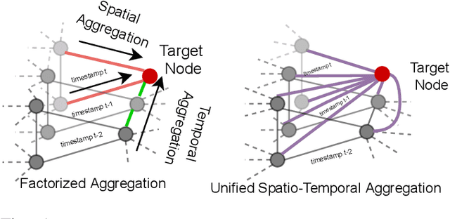
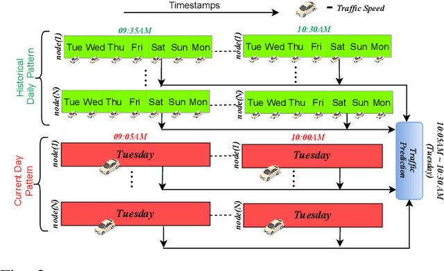


Abstract:Research in deep learning models to forecast traffic intensities has gained great attention in recent years due to their capability to capture the complex spatio-temporal relationships within the traffic data. However, most state-of-the-art approaches have designed spatial-only (e.g. Graph Neural Networks) and temporal-only (e.g. Recurrent Neural Networks) modules to separately extract spatial and temporal features. However, we argue that it is less effective to extract the complex spatio-temporal relationship with such factorized modules. Besides, most existing works predict the traffic intensity of a particular time interval only based on the traffic data of the previous one hour of that day. And thereby ignores the repetitive daily/weekly pattern that may exist in the last hour of data. Therefore, we propose a Unified Spatio-Temporal Graph Convolution Network (USTGCN) for traffic forecasting that performs both spatial and temporal aggregation through direct information propagation across different timestamp nodes with the help of spectral graph convolution on a spatio-temporal graph. Furthermore, it captures historical daily patterns in previous days and current-day patterns in current-day traffic data. Finally, we validate our work's effectiveness through experimental analysis, which shows that our model USTGCN can outperform state-of-the-art performances in three popular benchmark datasets from the Performance Measurement System (PeMS). Moreover, the training time is reduced significantly with our proposed USTGCN model.
Node Embedding using Mutual Information and Self-Supervision based Bi-level Aggregation
Apr 27, 2021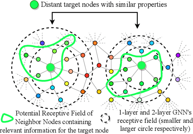


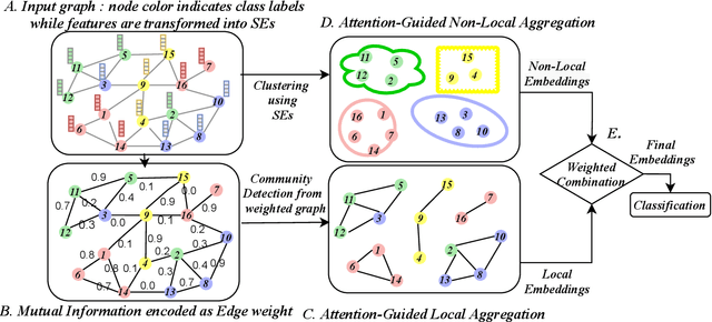
Abstract:Graph Neural Networks (GNNs) learn low dimensional representations of nodes by aggregating information from their neighborhood in graphs. However, traditional GNNs suffer from two fundamental shortcomings due to their local ($l$-hop neighborhood) aggregation scheme. First, not all nodes in the neighborhood carry relevant information for the target node. Since GNNs do not exclude noisy nodes in their neighborhood, irrelevant information gets aggregated, which reduces the quality of the representation. Second, traditional GNNs also fail to capture long-range non-local dependencies between nodes. To address these limitations, we exploit mutual information (MI) to define two types of neighborhood, 1) \textit{Local Neighborhood} where nodes are densely connected within a community and each node would share higher MI with its neighbors, and 2) \textit{Non-Local Neighborhood} where MI-based node clustering is introduced to assemble informative but graphically distant nodes in the same cluster. To generate node presentations, we combine the embeddings generated by bi-level aggregation - local aggregation to aggregate features from local neighborhoods to avoid noisy information and non-local aggregation to aggregate features from non-local neighborhoods. Furthermore, we leverage self-supervision learning to estimate MI with few labeled data. Finally, we show that our model significantly outperforms the state-of-the-art methods in a wide range of assortative and disassortative graphs.
Structure-Aware Hierarchical Graph Pooling using Information Bottleneck
Apr 27, 2021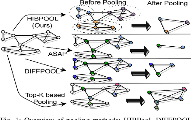


Abstract:Graph pooling is an essential ingredient of Graph Neural Networks (GNNs) in graph classification and regression tasks. For these tasks, different pooling strategies have been proposed to generate a graph-level representation by downsampling and summarizing nodes' features in a graph. However, most existing pooling methods are unable to capture distinguishable structural information effectively. Besides, they are prone to adversarial attacks. In this work, we propose a novel pooling method named as {HIBPool} where we leverage the Information Bottleneck (IB) principle that optimally balances the expressiveness and robustness of a model to learn representations of input data. Furthermore, we introduce a novel structure-aware Discriminative Pooling Readout ({DiP-Readout}) function to capture the informative local subgraph structures in the graph. Finally, our experimental results show that our model significantly outperforms other state-of-art methods on several graph classification benchmarks and more resilient to feature-perturbation attack than existing pooling methods.
SST-GNN: Simplified Spatio-temporal Traffic forecasting model using Graph Neural Network
Mar 31, 2021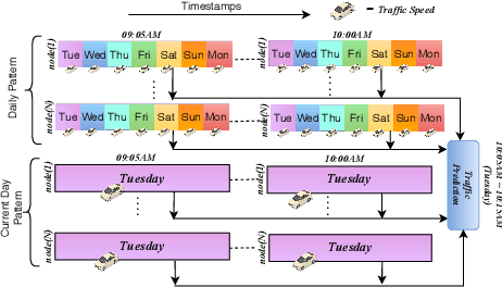
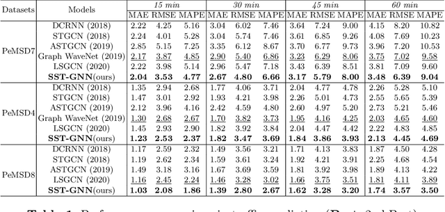
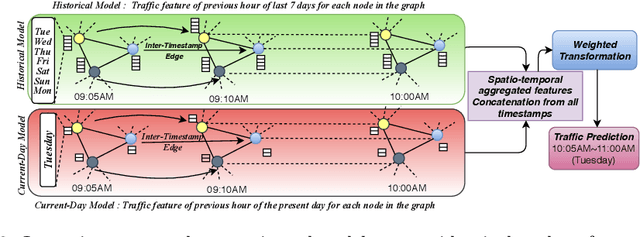

Abstract:To capture spatial relationships and temporal dynamics in traffic data, spatio-temporal models for traffic forecasting have drawn significant attention in recent years. Most of the recent works employed graph neural networks(GNN) with multiple layers to capture the spatial dependency. However, road junctions with different hop-distance can carry distinct traffic information which should be exploited separately but existing multi-layer GNNs are incompetent to discriminate between their impact. Again, to capture the temporal interrelationship, recurrent neural networks are common in state-of-the-art approaches that often fail to capture long-range dependencies. Furthermore, traffic data shows repeated patterns in a daily or weekly period which should be addressed explicitly. To address these limitations, we have designed a Simplified Spatio-temporal Traffic forecasting GNN(SST-GNN) that effectively encodes the spatial dependency by separately aggregating different neighborhood representations rather than with multiple layers and capture the temporal dependency with a simple yet effective weighted spatio-temporal aggregation mechanism. We capture the periodic traffic patterns by using a novel position encoding scheme with historical and current data in two different models. With extensive experimental analysis, we have shown that our model has significantly outperformed the state-of-the-art models on three real-world traffic datasets from the Performance Measurement System (PeMS).
 Add to Chrome
 Add to Firefox
 Add to Edge