June Moh Goo
Real-Time LiDAR Super-Resolution via Frequency-Aware Multi-Scale Fusion
Nov 10, 2025Abstract:LiDAR super-resolution addresses the challenge of achieving high-quality 3D perception from cost-effective, low-resolution sensors. While recent transformer-based approaches like TULIP show promise, they remain limited to spatial-domain processing with restricted receptive fields. We introduce FLASH (Frequency-aware LiDAR Adaptive Super-resolution with Hierarchical fusion), a novel framework that overcomes these limitations through dual-domain processing. FLASH integrates two key innovations: (i) Frequency-Aware Window Attention that combines local spatial attention with global frequency-domain analysis via FFT, capturing both fine-grained geometry and periodic scanning patterns at log-linear complexity. (ii) Adaptive Multi-Scale Fusion that replaces conventional skip connections with learned position-specific feature aggregation, enhanced by CBAM attention for dynamic feature selection. Extensive experiments on KITTI demonstrate that FLASH achieves state-of-the-art performance across all evaluation metrics, surpassing even uncertainty-enhanced baselines that require multiple forward passes. Notably, FLASH outperforms TULIP with Monte Carlo Dropout while maintaining single-pass efficiency, which enables real-time deployment. The consistent superiority across all distance ranges validates that our dual-domain approach effectively handles uncertainty through architectural design rather than computationally expensive stochastic inference, making it practical for autonomous systems.
Hybrid-Segmentor: A Hybrid Approach to Automated Fine-Grained Crack Segmentation in Civil Infrastructure
Sep 04, 2024
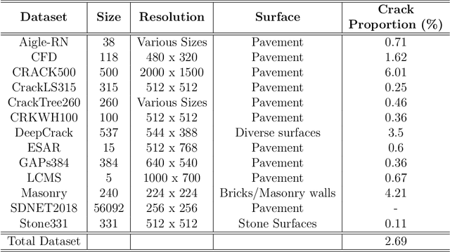
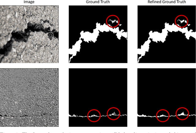
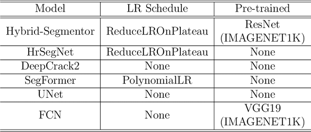
Abstract:Detecting and segmenting cracks in infrastructure, such as roads and buildings, is crucial for safety and cost-effective maintenance. In spite of the potential of deep learning, there are challenges in achieving precise results and handling diverse crack types. With the proposed dataset and model, we aim to enhance crack detection and infrastructure maintenance. We introduce Hybrid-Segmentor, an encoder-decoder based approach that is capable of extracting both fine-grained local and global crack features. This allows the model to improve its generalization capabilities in distinguish various type of shapes, surfaces and sizes of cracks. To keep the computational performances low for practical purposes, while maintaining the high the generalization capabilities of the model, we incorporate a self-attention model at the encoder level, while reducing the complexity of the decoder component. The proposed model outperforms existing benchmark models across 5 quantitative metrics (accuracy 0.971, precision 0.804, recall 0.744, F1-score 0.770, and IoU score 0.630), achieving state-of-the-art status.
V-RoAst: A New Dataset for Visual Road Assessment
Aug 21, 2024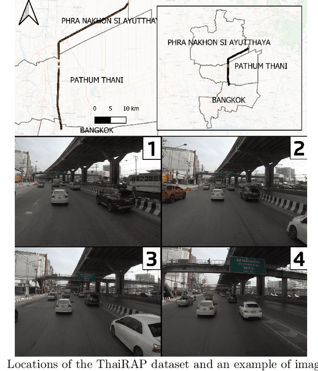

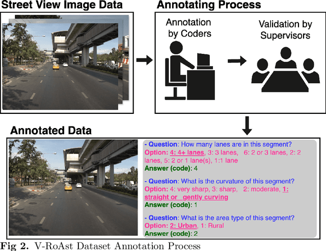
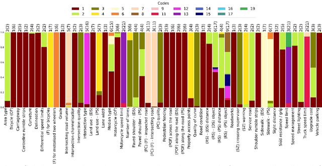
Abstract:Road traffic crashes cause millions of deaths annually and have a significant economic impact, particularly in low- and middle-income countries (LMICs). This paper presents an approach using Vision Language Models (VLMs) for road safety assessment, overcoming the limitations of traditional Convolutional Neural Networks (CNNs). We introduce a new task ,V-RoAst (Visual question answering for Road Assessment), with a real-world dataset. Our approach optimizes prompt engineering and evaluates advanced VLMs, including Gemini-1.5-flash and GPT-4o-mini. The models effectively examine attributes for road assessment. Using crowdsourced imagery from Mapillary, our scalable solution influentially estimates road safety levels. In addition, this approach is designed for local stakeholders who lack resources, as it does not require training data. It offers a cost-effective and automated methods for global road safety assessments, potentially saving lives and reducing economic burdens.
Zero-shot Building Age Classification from Facade Image Using GPT-4
Apr 15, 2024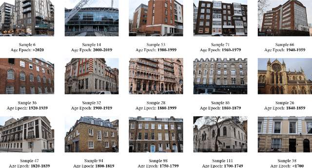

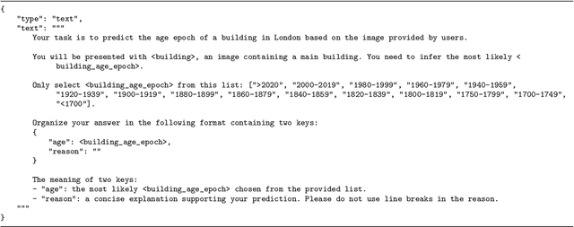

Abstract:A building's age of construction is crucial for supporting many geospatial applications. Much current research focuses on estimating building age from facade images using deep learning. However, building an accurate deep learning model requires a considerable amount of labelled training data, and the trained models often have geographical constraints. Recently, large pre-trained vision language models (VLMs) such as GPT-4 Vision, which demonstrate significant generalisation capabilities, have emerged as potential training-free tools for dealing with specific vision tasks, but their applicability and reliability for building information remain unexplored. In this study, a zero-shot building age classifier for facade images is developed using prompts that include logical instructions. Taking London as a test case, we introduce a new dataset, FI-London, comprising facade images and building age epochs. Although the training-free classifier achieved a modest accuracy of 39.69%, the mean absolute error of 0.85 decades indicates that the model can predict building age epochs successfully albeit with a small bias. The ensuing discussion reveals that the classifier struggles to predict the age of very old buildings and is challenged by fine-grained predictions within 2 decades. Overall, the classifier utilising GPT-4 Vision is capable of predicting the rough age epoch of a building from a single facade image without any training.
Zero-shot detection of buildings in mobile LiDAR using Language Vision Model
Apr 15, 2024
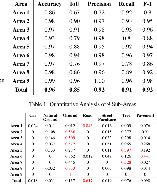
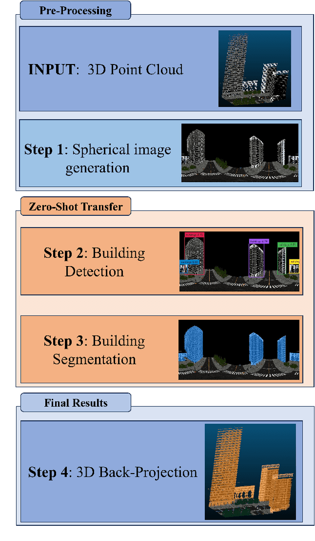
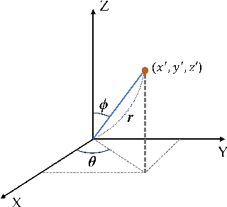
Abstract:Recent advances have demonstrated that Language Vision Models (LVMs) surpass the existing State-of-the-Art (SOTA) in two-dimensional (2D) computer vision tasks, motivating attempts to apply LVMs to three-dimensional (3D) data. While LVMs are efficient and effective in addressing various downstream 2D vision tasks without training, they face significant challenges when it comes to point clouds, a representative format for representing 3D data. It is more difficult to extract features from 3D data and there are challenges due to large data sizes and the cost of the collection and labelling, resulting in a notably limited availability of datasets. Moreover, constructing LVMs for point clouds is even more challenging due to the requirements for large amounts of data and training time. To address these issues, our research aims to 1) apply the Grounded SAM through Spherical Projection to transfer 3D to 2D, and 2) experiment with synthetic data to evaluate its effectiveness in bridging the gap between synthetic and real-world data domains. Our approach exhibited high performance with an accuracy of 0.96, an IoU of 0.85, precision of 0.92, recall of 0.91, and an F1 score of 0.92, confirming its potential. However, challenges such as occlusion problems and pixel-level overlaps of multi-label points during spherical image generation remain to be addressed in future studies.
Socio-Economic Deprivation Analysis: Diffusion Maps
Dec 15, 2023Abstract:This report proposes a model to predict the location of the most deprived areas in a city using data from the census. A census data is very high dimensional and needs to be simplified. We use a novel algorithm to reduce dimensionality and find patterns: The diffusion map. Features are defined by eigenvectors of the Laplacian matrix that defines the diffusion map. Eigenvectors corresponding to the smallest eigenvalues indicate specific population features. Previous work has found qualitatively that the second most important dimension for describing the census data in Bristol is linked to deprivation. In this report, we analyse how good this dimension is as a model for predicting deprivation by comparing with the recognised measures. The Pearson correlation coefficient was found to be over 0.7. The top 10 per cent of deprived areas in the UK which also locate in Bristol are extracted to test the accuracy of the model. There are 52 most deprived areas, and 38 areas are correctly identified by comparing to the model. The influence of scores of IMD domains that do not correlate with the models, Eigenvector 2 entries of non-deprived OAs and orthogonality of Eigenvectors cause the model to fail the prediction of 14 deprived areas. However, overall, the model shows a high performance to predict the future deprivation of overall areas where the project considers. This project is expected to support the government to allocate resources and funding.
 Add to Chrome
 Add to Firefox
 Add to Edge