Jiong Deng
Benchmarking the Robustness of LiDAR-Camera Fusion for 3D Object Detection
May 30, 2022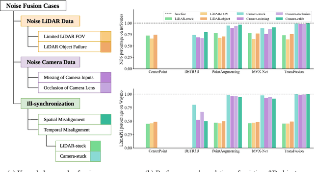
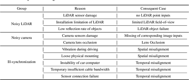

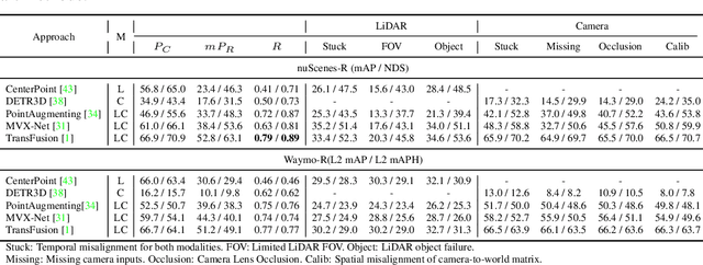
Abstract:There are two critical sensors for 3D perception in autonomous driving, the camera and the LiDAR. The camera provides rich semantic information such as color, texture, and the LiDAR reflects the 3D shape and locations of surrounding objects. People discover that fusing these two modalities can significantly boost the performance of 3D perception models as each modality has complementary information to the other. However, we observe that current datasets are captured from expensive vehicles that are explicitly designed for data collection purposes, and cannot truly reflect the realistic data distribution due to various reasons. To this end, we collect a series of real-world cases with noisy data distribution, and systematically formulate a robustness benchmark toolkit, that simulates these cases on any clean autonomous driving datasets. We showcase the effectiveness of our toolkit by establishing the robustness benchmark on two widely-adopted autonomous driving datasets, nuScenes and Waymo, then, to the best of our knowledge, holistically benchmark the state-of-the-art fusion methods for the first time. We observe that: i) most fusion methods, when solely developed on these data, tend to fail inevitably when there is a disruption to the LiDAR input; ii) the improvement of the camera input is significantly inferior to the LiDAR one. We further propose an efficient robust training strategy to improve the robustness of the current fusion method. The benchmark and code are available at https://github.com/kcyu2014/lidar-camera-robust-benchmark
3D Lidar Mapping Relative Accuracy Automatic Evaluation Algorithm
Jun 01, 2020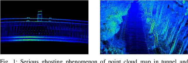
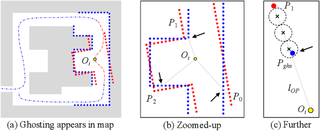
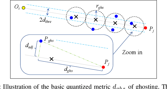
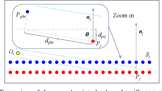
Abstract:HD (High Definition) map based on 3D lidar plays a vital role in autonomous vehicle localization, planning, decision-making, perception, etc. Many 3D lidar mapping technologies related to SLAM (Simultaneous Localization and Mapping) are used in HD map construction to ensure its high accuracy. To evaluate the accuracy of 3D lidar mapping, the most common methods use ground truth of poses to calculate the error between estimated poses and ground truth, however it's usually so difficult to get the ground truth of poses in the actual lidar mapping for autonomous vehicle. In this paper, we proposed a relative accuracy evaluation algorithm that can automatically evaluate the accuracy of HD map built by 3D lidar mapping without ground truth. A method for detecting the degree of ghosting in point cloud map quantitatively is designed to reflect the accuracy indirectly, which takes advantage of the principle of light traveling in a straight line and the fact that light can not penetrate opaque objects. Our experimental results confirm that the proposed evaluation algorithm can automatically and efficiently detect the bad poses whose accuracy are less than the set threshold such as 0.1m, then calculate the bad poses percentage P_bad in all estimated poses to obtain the final accuracy metric P_acc = 1 - P_bad.
 Add to Chrome
 Add to Firefox
 Add to Edge