Itzik Klein
PiDR: Physics-Informed Inertial Dead Reckoning for Autonomous Platforms
Jan 06, 2026Abstract:A fundamental requirement for full autonomy is the ability to sustain accurate navigation in the absence of external data, such as GNSS signals or visual information. In these challenging environments, the platform must rely exclusively on inertial sensors, leading to pure inertial navigation. However, the inherent noise and other error terms of the inertial sensors in such real-world scenarios will cause the navigation solution to drift over time. Although conventional deep-learning models have emerged as a possible approach to inertial navigation, they are inherently black-box in nature. Furthermore, they struggle to learn effectively with limited supervised sensor data and often fail to preserve physical principles. To address these limitations, we propose PiDR, a physics-informed inertial dead-reckoning framework for autonomous platforms in situations of pure inertial navigation. PiDR offers transparency by explicitly integrating inertial navigation principles into the network training process through the physics-informed residual component. PiDR plays a crucial role in mitigating abrupt trajectory deviations even under limited or sparse supervision. We evaluated PiDR on real-world datasets collected by a mobile robot and an autonomous underwater vehicle. We obtained more than 29% positioning improvement in both datasets, demonstrating the ability of PiDR to generalize different platforms operating in various environments and dynamics. Thus, PiDR offers a robust, lightweight, yet effective architecture and can be deployed on resource-constrained platforms, enabling real-time pure inertial navigation in adverse scenarios.
Pure Inertial Navigation in Challenging Environments with Wheeled and Chassis Mounted Inertial Sensors
Jan 01, 2026Abstract:Autonomous vehicles and wheeled robots are widely used in many applications in both indoor and outdoor settings. In practical situations with limited GNSS signals or degraded lighting conditions, the navigation solution may rely only on inertial sensors and as result drift in time due to errors in the inertial measurement. In this work, we propose WiCHINS, a wheeled and chassis inertial navigation system by combining wheel-mounted-inertial sensors with a chassis-mounted inertial sensor for accurate pure inertial navigation. To that end, we derive a three-stage framework, each with a dedicated extended Kalman filter. This framework utilizes the benefits of each location (wheel/body) during the estimation process. To evaluate our proposed approach, we employed a dataset with five inertial measurement units with a total recording time of 228.6 minutes. We compare our approach with four other inertial baselines and demonstrate an average position error of 11.4m, which is $2.4\%$ of the average traveled distance, using two wheels and one body inertial measurement units. As a consequence, our proposed method enables robust navigation in challenging environments and helps bridge the pure-inertial performance gap.
Simultaneous Localization and 3D-Semi Dense Mapping for Micro Drones Using Monocular Camera and Inertial Sensors
Nov 18, 2025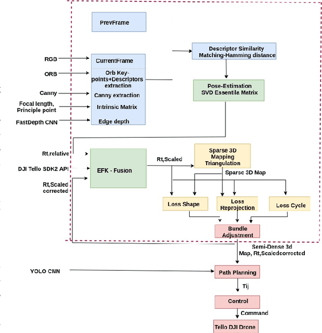
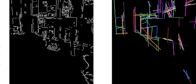
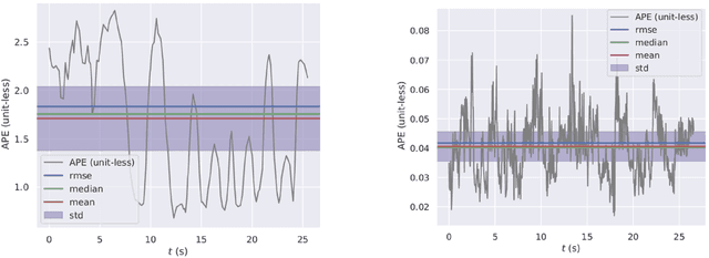

Abstract:Monocular simultaneous localization and mapping (SLAM) algorithms estimate drone poses and build a 3D map using a single camera. Current algorithms include sparse methods that lack detailed geometry, while learning-driven approaches produce dense maps but are computationally intensive. Monocular SLAM also faces scale ambiguities, which affect its accuracy. To address these challenges, we propose an edge-aware lightweight monocular SLAM system combining sparse keypoint-based pose estimation with dense edge reconstruction. Our method employs deep learning-based depth prediction and edge detection, followed by optimization to refine keypoints and edges for geometric consistency, without relying on global loop closure or heavy neural computations. We fuse inertial data with vision by using an extended Kalman filter to resolve scale ambiguity and improve accuracy. The system operates in real time on low-power platforms, as demonstrated on a DJI Tello drone with a monocular camera and inertial sensors. In addition, we demonstrate robust autonomous navigation and obstacle avoidance in indoor corridors and on the TUM RGBD dataset. Our approach offers an effective, practical solution to real-time mapping and navigation in resource-constrained environments.
Orientation-Free Neural Network-Based Bias Estimation for Low-Cost Stationary Accelerometers
Nov 17, 2025Abstract:Low-cost micro-electromechanical accelerometers are widely used in navigation, robotics, and consumer devices for motion sensing and position estimation. However, their performance is often degraded by bias errors. To eliminate deterministic bias terms a calibration procedure is applied under stationary conditions. It requires accelerom- eter leveling or complex orientation-dependent calibration procedures. To overcome those requirements, in this paper we present a model-free learning-based calibration method that estimates accelerometer bias under stationary conditions, without requiring knowledge of the sensor orientation and without the need to rotate the sensors. The proposed approach provides a fast, practical, and scalable solution suitable for rapid field deployment. Experimental validation on a 13.39-hour dataset collected from six accelerometers shows that the proposed method consistently achieves error levels more than 52% lower than traditional techniques. On a broader scale, this work contributes to the advancement of accurate calibration methods in orientation-free scenarios. As a consequence, it improves the reliability of low-cost inertial sensors in diverse scientific and industrial applications and eliminates the need for leveled calibration.
ResAlignNet: A Data-Driven Approach for INS/DVL Alignment
Nov 17, 2025Abstract:Autonomous underwater vehicles rely on precise navigation systems that combine the inertial navigation system and the Doppler velocity log for successful missions in challenging environments where satellite navigation is unavailable. The effectiveness of this integration critically depends on accurate alignment between the sensor reference frames. Standard model-based alignment methods between these sensor systems suffer from lengthy convergence times, dependence on prescribed motion patterns, and reliance on external aiding sensors, significantly limiting operational flexibility. To address these limitations, this paper presents ResAlignNet, a data-driven approach using the 1D ResNet-18 architecture that transforms the alignment problem into deep neural network optimization, operating as an in-situ solution that requires only sensors on board without external positioning aids or complex vehicle maneuvers, while achieving rapid convergence in seconds. Additionally, the approach demonstrates the learning capabilities of Sim2Real transfer, enabling training in synthetic data while deploying in operational sensor measurements. Experimental validation using the Snapir autonomous underwater vehicle demonstrates that ResAlignNet achieves alignment accuracy within 0.8° using only 25 seconds of data collection, representing a 65\% reduction in convergence time compared to standard velocity-based methods. The trajectory-independent solution eliminates motion pattern requirements and enables immediate vehicle deployment without lengthy pre-mission procedures, advancing underwater navigation capabilities through robust sensor-agnostic alignment that scales across different operational scenarios and sensor specifications.
Diffusion-Driven Inertial Generated Data for Smartphone Location Classification
Apr 20, 2025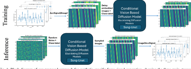

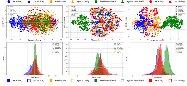

Abstract:Despite the crucial role of inertial measurements in motion tracking and navigation systems, the time-consuming and resource-intensive nature of collecting extensive inertial data has hindered the development of robust machine learning models in this field. In recent years, diffusion models have emerged as a revolutionary class of generative models, reshaping the landscape of artificial data generation. These models surpass generative adversarial networks and other state-of-the-art approaches to complex tasks. In this work, we propose diffusion-driven specific force-generated data for smartphone location recognition. We provide a comprehensive evaluation methodology by comparing synthetic and real recorded specific force data across multiple metrics. Our results demonstrate that our diffusion-based generative model successfully captures the distinctive characteristics of specific force signals across different smartphone placement conditions. Thus, by creating diverse, realistic synthetic data, we can reduce the burden of extensive data collection while providing high-quality training data for machine learning models.
Transformer-Based Robust Underwater Inertial Navigation in Prolonged Doppler Velocity Log Outages
Apr 10, 2025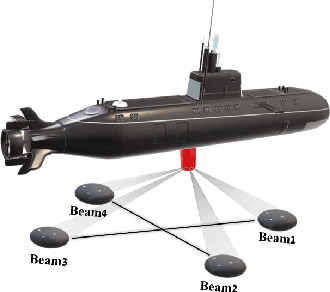
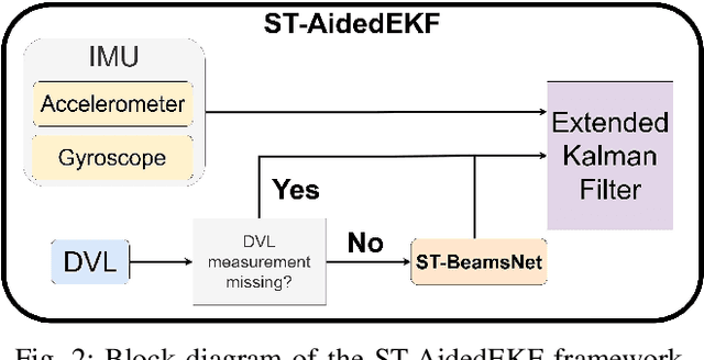

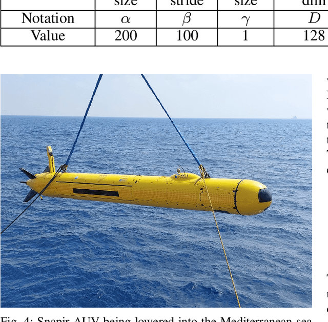
Abstract:Autonomous underwater vehicles (AUV) have a wide variety of applications in the marine domain, including exploration, surveying, and mapping. Their navigation systems rely heavily on fusing data from inertial sensors and a Doppler velocity log (DVL), typically via nonlinear filtering. The DVL estimates the AUV's velocity vector by transmitting acoustic beams to the seabed and analyzing the Doppler shift from the reflected signals. However, due to environmental challenges, DVL beams can deflect or fail in real-world settings, causing signal outages. In such cases, the AUV relies solely on inertial data, leading to accumulated navigation errors and mission terminations. To cope with these outages, we adopted ST-BeamsNet, a deep learning approach that uses inertial readings and prior DVL data to estimate AUV velocity during isolated outages. In this work, we extend ST-BeamsNet to address prolonged DVL outages and evaluate its impact within an extended Kalman filter framework. Experiments demonstrate that the proposed framework improves velocity RMSE by up to 63% and reduces final position error by up to 95% compared to pure inertial navigation. This is in scenarios involving up to 50 seconds of complete DVL outage.
Design and Experimental Validation of an Autonomous USV for Sensor Fusion-Based Navigation in GNSS-Denied Environments
Mar 30, 2025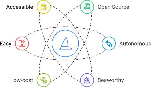
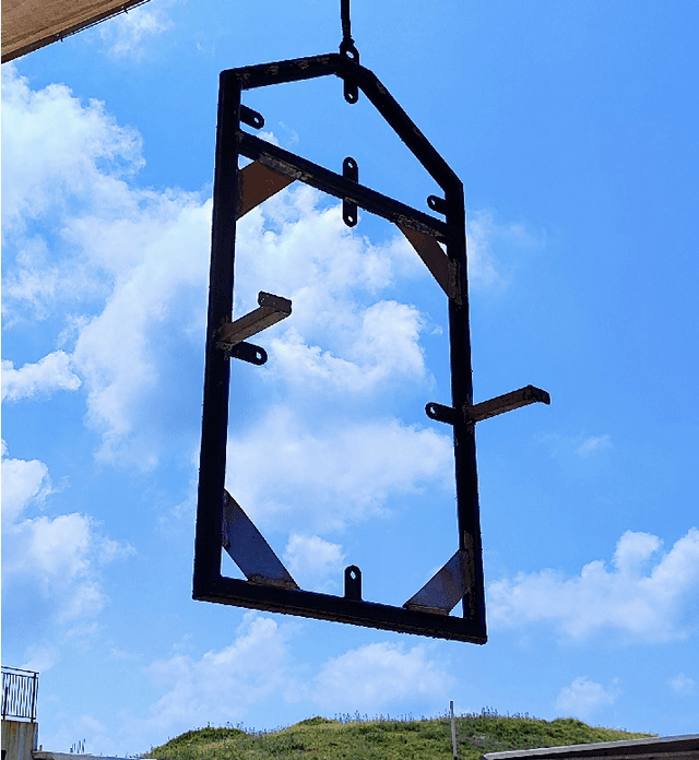
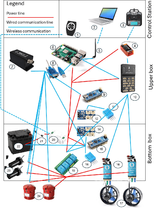
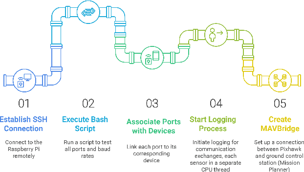
Abstract:This paper presents the design, development, and experimental validation of MARVEL, an autonomous unmanned surface vehicle built for real-world testing of sensor fusion-based navigation algorithms in GNSS-denied environments. MARVEL was developed under strict constraints of cost-efficiency, portability, and seaworthiness, with the goal of creating a modular, accessible platform for high-frequency data acquisition and experimental learning. It integrates electromagnetic logs, Doppler velocity logs, inertial sensors, and real-time kinematic GNSS positioning. MARVEL enables real-time, in-situ validation of advanced navigation and AI-driven algorithms using redundant, synchronized sensors. Field experiments demonstrate the system's stability, maneuverability, and adaptability in challenging sea conditions. The platform offers a novel, scalable approach for researchers seeking affordable, open-ended tools to evaluate sensor fusion techniques under real-world maritime constraints.
A Data-Driven Method for INS/DVL Alignment
Mar 27, 2025Abstract:Autonomous underwater vehicles (AUVs) are sophisticated robotic platforms crucial for a wide range of applications. The accuracy of AUV navigation systems is critical to their success. Inertial sensors and Doppler velocity logs (DVL) fusion is a promising solution for long-range underwater navigation. However, the effectiveness of this fusion depends heavily on an accurate alignment between the inertial sensors and the DVL. While current alignment methods show promise, there remains significant room for improvement in terms of accuracy, convergence time, and alignment trajectory efficiency. In this research we propose an end-to-end deep learning framework for the alignment process. By leveraging deep-learning capabilities, such as noise reduction and capture of nonlinearities in the data, we show using simulative data, that our proposed approach enhances both alignment accuracy and reduces convergence time beyond current model-based methods.
Enhancing Underwater Navigation through Cross-Correlation-Aware Deep INS/DVL Fusion
Mar 27, 2025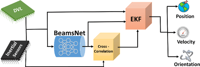
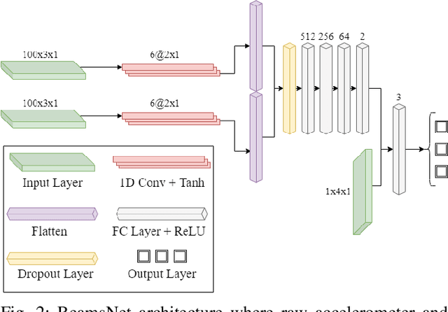
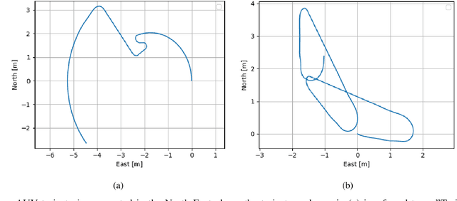
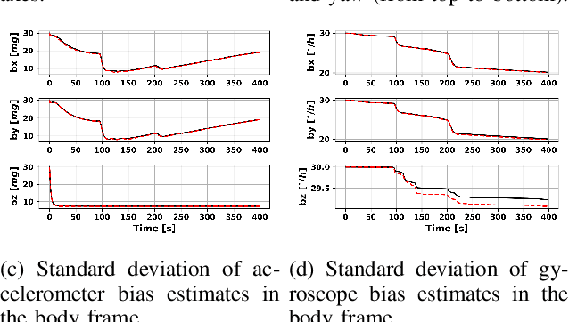
Abstract:The accurate navigation of autonomous underwater vehicles critically depends on the precision of Doppler velocity log (DVL) velocity measurements. Recent advancements in deep learning have demonstrated significant potential in improving DVL outputs by leveraging spatiotemporal dependencies across multiple sensor modalities. However, integrating these estimates into model-based filters, such as the extended Kalman filter, introduces statistical inconsistencies, most notably, cross-correlations between process and measurement noise. This paper addresses this challenge by proposing a cross-correlation-aware deep INS/DVL fusion framework. Building upon BeamsNet, a convolutional neural network designed to estimate AUV velocity using DVL and inertial data, we integrate its output into a navigation filter that explicitly accounts for the cross-correlation induced between the noise sources. This approach improves filter consistency and better reflects the underlying sensor error structure. Evaluated on two real-world underwater trajectories, the proposed method outperforms both least squares and cross-correlation-neglecting approaches in terms of state uncertainty. Notably, improvements exceed 10% in velocity and misalignment angle confidence metrics. Beyond demonstrating empirical performance, this framework provides a theoretically principled mechanism for embedding deep learning outputs within stochastic filters.
 Add to Chrome
 Add to Firefox
 Add to Edge