Dongsuk Kum
REOcc: Camera-Radar Fusion with Radar Feature Enrichment for 3D Occupancy Prediction
Nov 10, 2025


Abstract:Vision-based 3D occupancy prediction has made significant advancements, but its reliance on cameras alone struggles in challenging environments. This limitation has driven the adoption of sensor fusion, among which camera-radar fusion stands out as a promising solution due to their complementary strengths. However, the sparsity and noise of the radar data limits its effectiveness, leading to suboptimal fusion performance. In this paper, we propose REOcc, a novel camera-radar fusion network designed to enrich radar feature representations for 3D occupancy prediction. Our approach introduces two main components, a Radar Densifier and a Radar Amplifier, which refine radar features by integrating spatial and contextual information, effectively enhancing spatial density and quality. Extensive experiments on the Occ3D-nuScenes benchmark demonstrate that REOcc achieves significant performance gains over the camera-only baseline model, particularly in dynamic object classes. These results underscore REOcc's capability to mitigate the sparsity and noise of the radar data. Consequently, radar complements camera data more effectively, unlocking the full potential of camera-radar fusion for robust and reliable 3D occupancy prediction.
LabelDistill: Label-guided Cross-modal Knowledge Distillation for Camera-based 3D Object Detection
Jul 14, 2024


Abstract:Recent advancements in camera-based 3D object detection have introduced cross-modal knowledge distillation to bridge the performance gap with LiDAR 3D detectors, leveraging the precise geometric information in LiDAR point clouds. However, existing cross-modal knowledge distillation methods tend to overlook the inherent imperfections of LiDAR, such as the ambiguity of measurements on distant or occluded objects, which should not be transferred to the image detector. To mitigate these imperfections in LiDAR teacher, we propose a novel method that leverages aleatoric uncertainty-free features from ground truth labels. In contrast to conventional label guidance approaches, we approximate the inverse function of the teacher's head to effectively embed label inputs into feature space. This approach provides additional accurate guidance alongside LiDAR teacher, thereby boosting the performance of the image detector. Additionally, we introduce feature partitioning, which effectively transfers knowledge from the teacher modality while preserving the distinctive features of the student, thereby maximizing the potential of both modalities. Experimental results demonstrate that our approach improves mAP and NDS by 5.1 points and 4.9 points compared to the baseline model, proving the effectiveness of our approach. The code is available at https://github.com/sanmin0312/LabelDistill
RadarDistill: Boosting Radar-based Object Detection Performance via Knowledge Distillation from LiDAR Features
Mar 08, 2024Abstract:The inherent noisy and sparse characteristics of radar data pose challenges in finding effective representations for 3D object detection. In this paper, we propose RadarDistill, a novel knowledge distillation (KD) method, which can improve the representation of radar data by leveraging LiDAR data. RadarDistill successfully transfers desirable characteristics of LiDAR features into radar features using three key components: Cross-Modality Alignment (CMA), Activation-based Feature Distillation (AFD), and Proposal-based Feature Distillation (PFD). CMA enhances the density of radar features through multiple layers of dilation operations, effectively addressing the challenges of inefficient knowledge transfer from LiDAR to radar. AFD is designed to transfer knowledge from significant areas of the LiDAR features, specifically those regions where activation intensity exceeds a predetermined threshold. PFD guides the radar network to mimic LiDAR network features in the object proposals for accurately detected results while moderating features for misdetected proposals like false positives. Our comparative analyses conducted on the nuScenes datasets demonstrate that RadarDistill achieves state-of-the-art (SOTA) performance for radar-only object detection task, recording 20.5% in mAP and 43.7% in NDS. Also, RadarDistill significantly improves the performance of the camera-radar fusion model.
RCM-Fusion: Radar-Camera Multi-Level Fusion for 3D Object Detection
Jul 27, 2023Abstract:While LiDAR sensors have been succesfully applied to 3D object detection, the affordability of radar and camera sensors has led to a growing interest in fusiong radars and cameras for 3D object detection. However, previous radar-camera fusion models have not been able to fully utilize radar information in that initial 3D proposals were generated based on the camera features only and the instance-level fusion is subsequently conducted. In this paper, we propose radar-camera multi-level fusion (RCM-Fusion), which fuses radar and camera modalities at both the feature-level and instance-level to fully utilize radar information. At the feature-level, we propose a Radar Guided BEV Encoder which utilizes radar Bird's-Eye-View (BEV) features to transform image features into precise BEV representations and then adaptively combines the radar and camera BEV features. At the instance-level, we propose a Radar Grid Point Refinement module that reduces localization error by considering the characteristics of the radar point clouds. The experiments conducted on the public nuScenes dataset demonstrate that our proposed RCM-Fusion offers 11.8% performance gain in nuScenes detection score (NDS) over the camera-only baseline model and achieves state-of-the-art performaces among radar-camera fusion methods in the nuScenes 3D object detection benchmark. Code will be made publicly available.
Predict to Detect: Prediction-guided 3D Object Detection using Sequential Images
Jun 14, 2023Abstract:Recent camera-based 3D object detection methods have introduced sequential frames to improve the detection performance hoping that multiple frames would mitigate the large depth estimation error. Despite improved detection performance, prior works rely on naive fusion methods (e.g., concatenation) or are limited to static scenes (e.g., temporal stereo), neglecting the importance of the motion cue of objects. These approaches do not fully exploit the potential of sequential images and show limited performance improvements. To address this limitation, we propose a novel 3D object detection model, P2D (Predict to Detect), that integrates a prediction scheme into a detection framework to explicitly extract and leverage motion features. P2D predicts object information in the current frame using solely past frames to learn temporal motion features. We then introduce a novel temporal feature aggregation method that attentively exploits Bird's-Eye-View (BEV) features based on predicted object information, resulting in accurate 3D object detection. Experimental results demonstrate that P2D improves mAP and NDS by 3.0% and 3.7% compared to the sequential image-based baseline, illustrating that incorporating a prediction scheme can significantly improve detection accuracy.
CRN: Camera Radar Net for Accurate, Robust, Efficient 3D Perception
Apr 03, 2023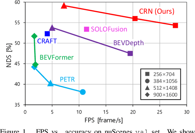
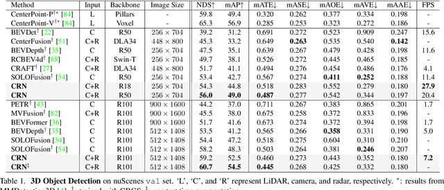

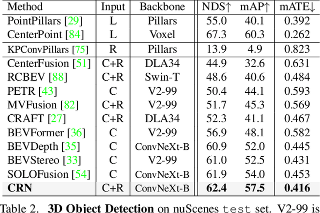
Abstract:Autonomous driving requires an accurate and fast 3D perception system that includes 3D object detection, tracking, and segmentation. Although recent low-cost camera-based approaches have shown promising results, they are susceptible to poor illumination or bad weather conditions and have a large localization error. Hence, fusing camera with low-cost radar, which provides precise long-range measurement and operates reliably in all environments, is promising but has not yet been thoroughly investigated. In this paper, we propose Camera Radar Net (CRN), a novel camera-radar fusion framework that generates a semantically rich and spatially accurate bird's-eye-view (BEV) feature map for various tasks. To overcome the lack of spatial information in an image, we transform perspective view image features to BEV with the help of sparse but accurate radar points. We further aggregate image and radar feature maps in BEV using multi-modal deformable attention designed to tackle the spatial misalignment between inputs. CRN with real-time setting operates at 20 FPS while achieving comparable performance to LiDAR detectors on nuScenes, and even outperforms at a far distance on 100m setting. Moreover, CRN with offline setting yields 62.4% NDS, 57.5% mAP on nuScenes test set and ranks first among all camera and camera-radar 3D object detectors.
InstaGraM: Instance-level Graph Modeling for Vectorized HD Map Learning
Jan 10, 2023

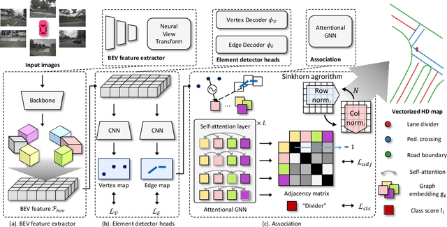

Abstract:The construction of lightweight High-definition (HD) maps containing geometric and semantic information is of foremost importance for the large-scale deployment of autonomous driving. To automatically generate such type of map from a set of images captured by a vehicle, most works formulate this mapping as a segmentation problem, which implies heavy post-processing to obtain the final vectorized representation. Alternative techniques have the ability to generate an HD map in an end-to-end manner but rely on computationally expensive auto-regressive models. To bring camera-based to an applicable level, we propose InstaGraM, a fast end-to-end network generating a vectorized HD map via instance-level graph modeling of the map elements. Our strategy consists of three main stages: top-view feature extraction, road elements' vertices and edges detection, and conversion to a semantic vector representation. After top-down feature extraction, an encoder-decoder architecture is utilized to predict a set of vertices and edge maps of the road elements. Finally, these vertices along with edge maps are associated through an attentional graph neural network generating a semantic vectorized map. Instead of relying on a common segmentation approach, we propose to regress distance transform maps as they provide strong spatial relations and directional information between vertices. Comprehensive experiments on nuScenes dataset show that our proposed network outperforms HDMapNet by 13.7 mAP and achieves comparable accuracy with VectorMapNet 5x faster inference speed.
3D Dual-Fusion: Dual-Domain Dual-Query Camera-LiDAR Fusion for 3D Object Detection
Nov 24, 2022Abstract:Fusing data from cameras and LiDAR sensors is an essential technique to achieve robust 3D object detection. One key challenge in camera-LiDAR fusion involves mitigating the large domain gap between the two sensors in terms of coordinates and data distribution when fusing their features. In this paper, we propose a novel camera-LiDAR fusion architecture called, 3D Dual-Fusion, which is designed to mitigate the gap between the feature representations of camera and LiDAR data. The proposed method fuses the features of the camera-view and 3D voxel-view domain and models their interactions through deformable attention. We redesign the transformer fusion encoder to aggregate the information from the two domains. Two major changes include 1) dual query-based deformable attention to fuse the dual-domain features interactively and 2) 3D local self-attention to encode the voxel-domain queries prior to dual-query decoding. The results of an experimental evaluation show that the proposed camera-LiDAR fusion architecture achieved competitive performance on the KITTI and nuScenes datasets, with state-of-the-art performances in some 3D object detection benchmarks categories.
Boosting Monocular 3D Object Detection with Object-Centric Auxiliary Depth Supervision
Oct 29, 2022Abstract:Recent advances in monocular 3D detection leverage a depth estimation network explicitly as an intermediate stage of the 3D detection network. Depth map approaches yield more accurate depth to objects than other methods thanks to the depth estimation network trained on a large-scale dataset. However, depth map approaches can be limited by the accuracy of the depth map, and sequentially using two separated networks for depth estimation and 3D detection significantly increases computation cost and inference time. In this work, we propose a method to boost the RGB image-based 3D detector by jointly training the detection network with a depth prediction loss analogous to the depth estimation task. In this way, our 3D detection network can be supervised by more depth supervision from raw LiDAR points, which does not require any human annotation cost, to estimate accurate depth without explicitly predicting the depth map. Our novel object-centric depth prediction loss focuses on depth around foreground objects, which is important for 3D object detection, to leverage pixel-wise depth supervision in an object-centric manner. Our depth regression model is further trained to predict the uncertainty of depth to represent the 3D confidence of objects. To effectively train the 3D detector with raw LiDAR points and to enable end-to-end training, we revisit the regression target of 3D objects and design a network architecture. Extensive experiments on KITTI and nuScenes benchmarks show that our method can significantly boost the monocular image-based 3D detector to outperform depth map approaches while maintaining the real-time inference speed.
CRAFT: Camera-Radar 3D Object Detection with Spatio-Contextual Fusion Transformer
Sep 14, 2022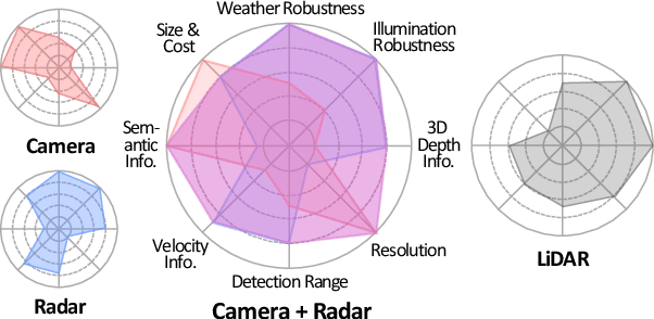

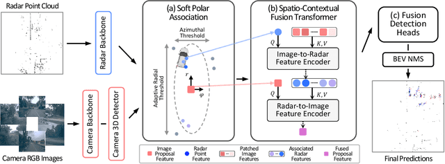

Abstract:Camera and radar sensors have significant advantages in cost, reliability, and maintenance compared to LiDAR. Existing fusion methods often fuse the outputs of single modalities at the result-level, called the late fusion strategy. This can benefit from using off-the-shelf single sensor detection algorithms, but late fusion cannot fully exploit the complementary properties of sensors, thus having limited performance despite the huge potential of camera-radar fusion. Here we propose a novel proposal-level early fusion approach that effectively exploits both spatial and contextual properties of camera and radar for 3D object detection. Our fusion framework first associates image proposal with radar points in the polar coordinate system to efficiently handle the discrepancy between the coordinate system and spatial properties. Using this as a first stage, following consecutive cross-attention based feature fusion layers adaptively exchange spatio-contextual information between camera and radar, leading to a robust and attentive fusion. Our camera-radar fusion approach achieves the state-of-the-art 41.1% mAP and 52.3% NDS on the nuScenes test set, which is 8.7 and 10.8 points higher than the camera-only baseline, as well as yielding competitive performance on the LiDAR method.
 Add to Chrome
 Add to Firefox
 Add to Edge