 Add to Chrome
 Add to Firefox
 Add to Edge
Learn to Rank: Visual Attribution by Learning Importance Ranking
Apr 07, 2026Interpreting the decisions of complex computer vision models is crucial to establish trust and accountability, especially in safety-critical domains. An established approach to interpretability is generating visual attribution maps that highlight regions of the input most relevant to the model's prediction. However, existing methods face a three-way trade-off. Propagation-based approaches are efficient, but they can be biased and architecture-specific. Meanwhile, perturbation-based methods are causally grounded, yet they are expensive and for vision transformers often yield coarse, patch-level explanations. Learning-based explainers are fast but usually optimize surrogate objectives or distill from heuristic teachers. We propose a learning scheme that instead optimizes deletion and insertion metrics directly. Since these metrics depend on non-differentiable sorting and ranking, we frame them as permutation learning and replace the hard sorting with a differentiable relaxation using Gumbel-Sinkhorn. This enables end-to-end training through attribution-guided perturbations of the target model. During inference, our method produces dense, pixel-level attributions in a single forward pass with optional, few-step gradient refinement. Our experiments demonstrate consistent quantitative improvements and sharper, boundary-aligned explanations, particularly for transformer-based vision models.
SHARP: Short-Window Streaming for Accurate and Robust Prediction in Motion Forecasting
Mar 30, 2026In dynamic traffic environments, motion forecasting models must be able to accurately estimate future trajectories continuously. Streaming-based methods are a promising solution, but despite recent advances, their performance often degrades when exposed to heterogeneous observation lengths. To address this, we propose a novel streaming-based motion forecasting framework that explicitly focuses on evolving scenes. Our method incrementally processes incoming observation windows and leverages an instance-aware context streaming to maintain and update latent agent representations across inference steps. A dual training objective further enables consistent forecasting accuracy across diverse observation horizons. Extensive experiments on Argoverse 2, nuScenes, and Argoverse 1 demonstrate the robustness of our approach under evolving scene conditions and also on the single-agent benchmarks. Our model achieves state-of-the-art performance in streaming inference on the Argoverse 2 multi-agent benchmark, while maintaining minimal latency, highlighting its suitability for real-world deployment.
The RoboSense Challenge: Sense Anything, Navigate Anywhere, Adapt Across Platforms
Jan 08, 2026Autonomous systems are increasingly deployed in open and dynamic environments -- from city streets to aerial and indoor spaces -- where perception models must remain reliable under sensor noise, environmental variation, and platform shifts. However, even state-of-the-art methods often degrade under unseen conditions, highlighting the need for robust and generalizable robot sensing. The RoboSense 2025 Challenge is designed to advance robustness and adaptability in robot perception across diverse sensing scenarios. It unifies five complementary research tracks spanning language-grounded decision making, socially compliant navigation, sensor configuration generalization, cross-view and cross-modal correspondence, and cross-platform 3D perception. Together, these tasks form a comprehensive benchmark for evaluating real-world sensing reliability under domain shifts, sensor failures, and platform discrepancies. RoboSense 2025 provides standardized datasets, baseline models, and unified evaluation protocols, enabling large-scale and reproducible comparison of robust perception methods. The challenge attracted 143 teams from 85 institutions across 16 countries, reflecting broad community engagement. By consolidating insights from 23 winning solutions, this report highlights emerging methodological trends, shared design principles, and open challenges across all tracks, marking a step toward building robots that can sense reliably, act robustly, and adapt across platforms in real-world environments.
STSBench: A Spatio-temporal Scenario Benchmark for Multi-modal Large Language Models in Autonomous Driving
Jun 06, 2025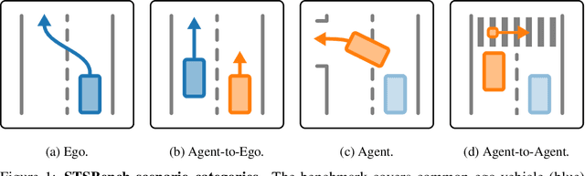
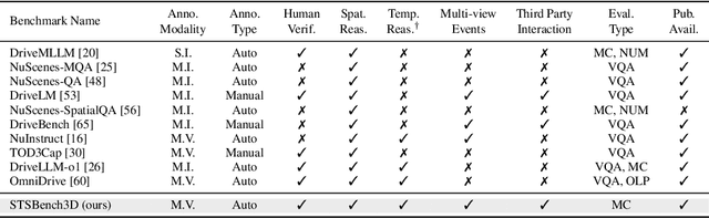
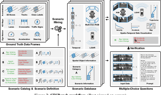
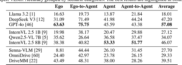
We introduce STSBench, a scenario-based framework to benchmark the holistic understanding of vision-language models (VLMs) for autonomous driving. The framework automatically mines pre-defined traffic scenarios from any dataset using ground-truth annotations, provides an intuitive user interface for efficient human verification, and generates multiple-choice questions for model evaluation. Applied to the NuScenes dataset, we present STSnu, the first benchmark that evaluates the spatio-temporal reasoning capabilities of VLMs based on comprehensive 3D perception. Existing benchmarks typically target off-the-shelf or fine-tuned VLMs for images or videos from a single viewpoint and focus on semantic tasks such as object recognition, dense captioning, risk assessment, or scene understanding. In contrast, STSnu evaluates driving expert VLMs for end-to-end driving, operating on videos from multi-view cameras or LiDAR. It specifically assesses their ability to reason about both ego-vehicle actions and complex interactions among traffic participants, a crucial capability for autonomous vehicles. The benchmark features 43 diverse scenarios spanning multiple views and frames, resulting in 971 human-verified multiple-choice questions. A thorough evaluation uncovers critical shortcomings in existing models' ability to reason about fundamental traffic dynamics in complex environments. These findings highlight the urgent need for architectural advances that explicitly model spatio-temporal reasoning. By addressing a core gap in spatio-temporal evaluation, STSBench enables the development of more robust and explainable VLMs for autonomous driving.
An Investigation of Beam Density on LiDAR Object Detection Performance
Mar 19, 2025


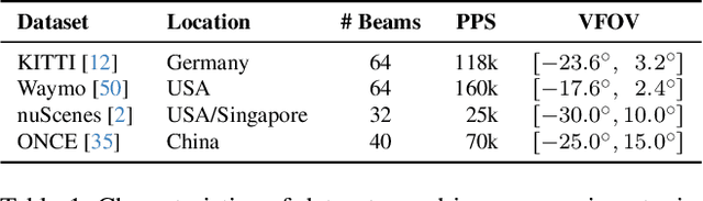
Accurate 3D object detection is a critical component of autonomous driving, enabling vehicles to perceive their surroundings with precision and make informed decisions. LiDAR sensors, widely used for their ability to provide detailed 3D measurements, are key to achieving this capability. However, variations between training and inference data can cause significant performance drops when object detection models are employed in different sensor settings. One critical factor is beam density, as inference on sparse, cost-effective LiDAR sensors is often preferred in real-world applications. Despite previous work addressing the beam-density-induced domain gap, substantial knowledge gaps remain, particularly concerning dense 128-beam sensors in cross-domain scenarios. To gain better understanding of the impact of beam density on domain gaps, we conduct a comprehensive investigation that includes an evaluation of different object detection architectures. Our architecture evaluation reveals that combining voxel- and point-based approaches yields superior cross-domain performance by leveraging the strengths of both representations. Building on these findings, we analyze beam-density-induced domain gaps and argue that these domain gaps must be evaluated in conjunction with other domain shifts. Contrary to conventional beliefs, our experiments reveal that detectors benefit from training on denser data and exhibit robustness to beam density variations during inference.
GBlobs: Explicit Local Structure via Gaussian Blobs for Improved Cross-Domain LiDAR-based 3D Object Detection
Mar 11, 2025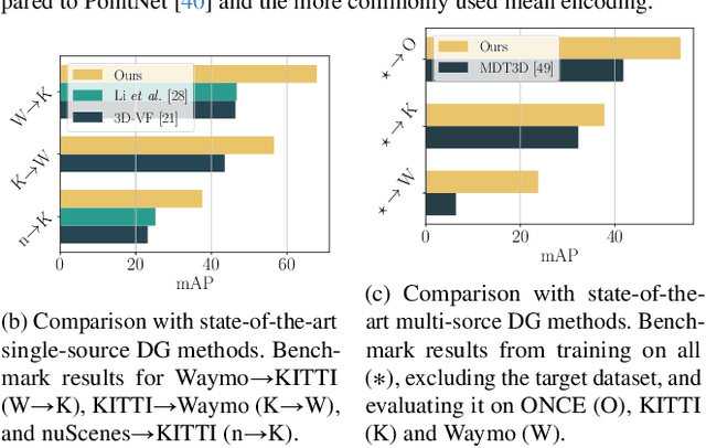
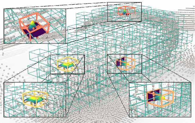
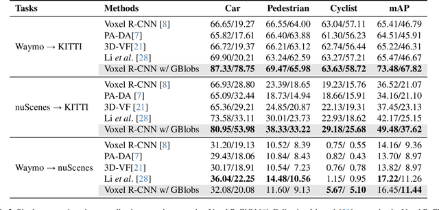
LiDAR-based 3D detectors need large datasets for training, yet they struggle to generalize to novel domains. Domain Generalization (DG) aims to mitigate this by training detectors that are invariant to such domain shifts. Current DG approaches exclusively rely on global geometric features (point cloud Cartesian coordinates) as input features. Over-reliance on these global geometric features can, however, cause 3D detectors to prioritize object location and absolute position, resulting in poor cross-domain performance. To mitigate this, we propose to exploit explicit local point cloud structure for DG, in particular by encoding point cloud neighborhoods with Gaussian blobs, GBlobs. Our proposed formulation is highly efficient and requires no additional parameters. Without any bells and whistles, simply by integrating GBlobs in existing detectors, we beat the current state-of-the-art in challenging single-source DG benchmarks by over 21 mAP (Waymo->KITTI), 13 mAP (KITTI->Waymo), and 12 mAP (nuScenes->KITTI), without sacrificing in-domain performance. Additionally, GBlobs demonstrate exceptional performance in multi-source DG, surpassing the current state-of-the-art by 17, 12, and 5 mAP on Waymo, KITTI, and ONCE, respectively.
LiSu: A Dataset and Method for LiDAR Surface Normal Estimation
Mar 11, 2025


While surface normals are widely used to analyse 3D scene geometry, surface normal estimation from LiDAR point clouds remains severely underexplored. This is caused by the lack of large-scale annotated datasets on the one hand, and lack of methods that can robustly handle the sparse and often noisy LiDAR data in a reasonable time on the other hand. We address these limitations using a traffic simulation engine and present LiSu, the first large-scale, synthetic LiDAR point cloud dataset with ground truth surface normal annotations, eliminating the need for tedious manual labeling. Additionally, we propose a novel method that exploits the spatiotemporal characteristics of autonomous driving data to enhance surface normal estimation accuracy. By incorporating two regularization terms, we enforce spatial consistency among neighboring points and temporal smoothness across consecutive LiDAR frames. These regularizers are particularly effective in self-training settings, where they mitigate the impact of noisy pseudo-labels, enabling robust real-world deployment. We demonstrate the effectiveness of our method on LiSu, achieving state-of-the-art performance in LiDAR surface normal estimation. Moreover, we showcase its full potential in addressing the challenging task of synthetic-to-real domain adaptation, leading to improved neural surface reconstruction on real-world data.
Vision-Language Guidance for LiDAR-based Unsupervised 3D Object Detection
Aug 07, 2024
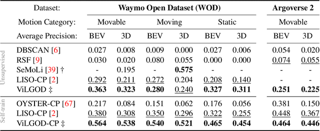
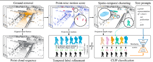
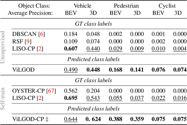
Accurate 3D object detection in LiDAR point clouds is crucial for autonomous driving systems. To achieve state-of-the-art performance, the supervised training of detectors requires large amounts of human-annotated data, which is expensive to obtain and restricted to predefined object categories. To mitigate manual labeling efforts, recent unsupervised object detection approaches generate class-agnostic pseudo-labels for moving objects, subsequently serving as supervision signal to bootstrap a detector. Despite promising results, these approaches do not provide class labels or generalize well to static objects. Furthermore, they are mostly restricted to data containing multiple drives from the same scene or images from a precisely calibrated and synchronized camera setup. To overcome these limitations, we propose a vision-language-guided unsupervised 3D detection approach that operates exclusively on LiDAR point clouds. We transfer CLIP knowledge to classify point clusters of static and moving objects, which we discover by exploiting the inherent spatio-temporal information of LiDAR point clouds for clustering, tracking, as well as box and label refinement. Our approach outperforms state-of-the-art unsupervised 3D object detectors on the Waymo Open Dataset ($+23~\text{AP}_{3D}$) and Argoverse 2 ($+7.9~\text{AP}_{3D}$) and provides class labels not solely based on object size assumptions, marking a significant advancement in the field.
GACE: Geometry Aware Confidence Enhancement for Black-Box 3D Object Detectors on LiDAR-Data
Oct 31, 2023


Widely-used LiDAR-based 3D object detectors often neglect fundamental geometric information readily available from the object proposals in their confidence estimation. This is mostly due to architectural design choices, which were often adopted from the 2D image domain, where geometric context is rarely available. In 3D, however, considering the object properties and its surroundings in a holistic way is important to distinguish between true and false positive detections, e.g. occluded pedestrians in a group. To address this, we present GACE, an intuitive and highly efficient method to improve the confidence estimation of a given black-box 3D object detector. We aggregate geometric cues of detections and their spatial relationships, which enables us to properly assess their plausibility and consequently, improve the confidence estimation. This leads to consistent performance gains over a variety of state-of-the-art detectors. Across all evaluated detectors, GACE proves to be especially beneficial for the vulnerable road user classes, i.e. pedestrians and cyclists.
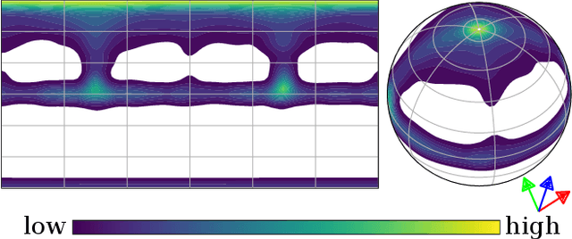
MAELi -- Masked Autoencoder for Large-Scale LiDAR Point Clouds
Dec 14, 2022


We show how the inherent, but often neglected, properties of large-scale LiDAR point clouds can be exploited for effective self-supervised representation learning. To this end, we design a highly data-efficient feature pre-training backbone that significantly reduces the amount of tedious 3D annotations to train state-of-the-art object detectors. In particular, we propose a Masked AutoEncoder (MAELi) that intuitively utilizes the sparsity of the LiDAR point clouds in both, the encoder and the decoder, during reconstruction. This results in more expressive and useful features, directly applicable to downstream perception tasks, such as 3D object detection for autonomous driving. In a novel reconstruction scheme, MAELi distinguishes between free and occluded space and leverages a new masking strategy which targets the LiDAR's inherent spherical projection. To demonstrate the potential of MAELi, we pre-train one of the most widespread 3D backbones, in an end-to-end fashion and show the merit of our fully unsupervised pre-trained features on several 3D object detection architectures. Given only a tiny fraction of labeled frames to fine-tune such detectors, we achieve significant performance improvements. For example, with only $\sim800$ labeled frames, MAELi features improve a SECOND model by +10.09APH/LEVEL 2 on Waymo Vehicles.