Brendan Englot
Stevens Institute of Technology
DRACo-SLAM2: Distributed Robust Acoustic Communication-efficient SLAM for Imaging Sonar EquippedUnderwater Robot Teams with Object Graph Matching
Jul 31, 2025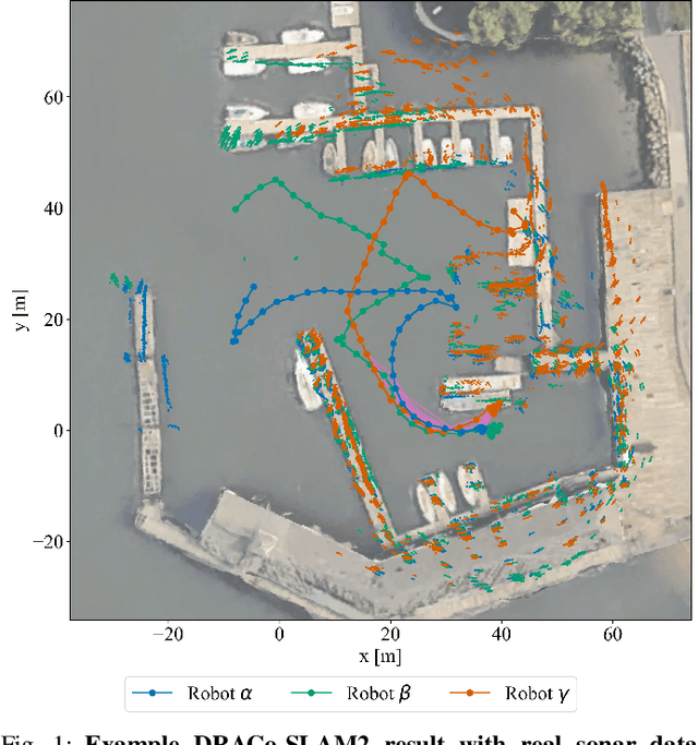
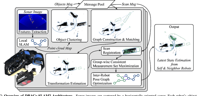
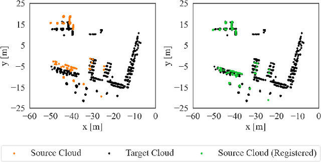
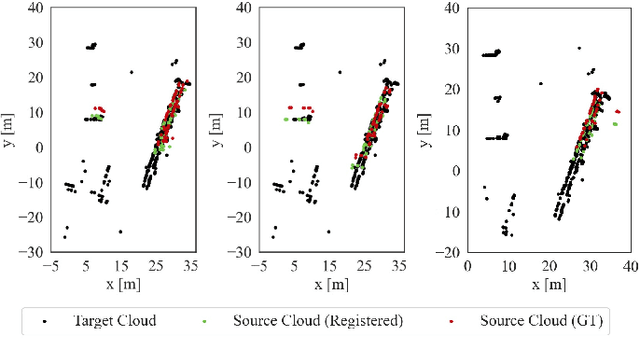
Abstract:We present DRACo-SLAM2, a distributed SLAM framework for underwater robot teams equipped with multibeam imaging sonar. This framework improves upon the original DRACo-SLAM by introducing a novel representation of sonar maps as object graphs and utilizing object graph matching to achieve time-efficient inter-robot loop closure detection without relying on prior geometric information. To better-accommodate the needs and characteristics of underwater scan matching, we propose incremental Group-wise Consistent Measurement Set Maximization (GCM), a modification of Pairwise Consistent Measurement Set Maximization (PCM), which effectively handles scenarios where nearby inter-robot loop closures share similar registration errors. The proposed approach is validated through extensive comparative analyses on simulated and real-world datasets.
Large-Scale Dense 3D Mapping Using Submaps Derived From Orthogonal Imaging Sonars
Dec 04, 2024Abstract:3D situational awareness is critical for any autonomous system. However, when operating underwater, environmental conditions often dictate the use of acoustic sensors. These acoustic sensors are plagued by high noise and a lack of 3D information in sonar imagery, motivating the use of an orthogonal pair of imaging sonars to recover 3D perceptual data. Thus far, mapping systems in this area only use a subset of the available data at discrete timesteps and rely on object-level prior information in the environment to develop high-coverage 3D maps. Moreover, simple repeating objects must be present to build high-coverage maps. In this work, we propose a submap-based mapping system integrated with a simultaneous localization and mapping (SLAM) system to produce dense, 3D maps of complex unknown environments with varying densities of simple repeating objects. We compare this submapping approach to our previous works in this area, analyzing simple and highly complex environments, such as submerged aircraft. We analyze the tradeoffs between a submapping-based approach and our previous work leveraging simple repeating objects. We show where each method is well-motivated and where they fall short. Importantly, our proposed use of submapping achieves an advance in underwater situational awareness with wide aperture multi-beam imaging sonar, moving toward generalized large-scale dense 3D mapping capability for fully unknown complex environments.
A Bimanual Teleoperation Framework for Light Duty Underwater Vehicle-Manipulator Systems
Apr 04, 2024Abstract:In an effort to lower the barrier to entry in underwater manipulation, this paper presents an open-source, user-friendly framework for bimanual teleoperation of a light-duty underwater vehicle-manipulator system (UVMS). This framework allows for the control of the vehicle along with two manipulators and their end-effectors using two low-cost haptic devices. The UVMS kinematics are derived in order to create an independent resolved motion rate controller for each manipulator, which optimally controls the joint positions to achieve a desired end-effector pose. This desired pose is computed in real-time using a teleoperation controller developed to process the dual haptic device input from the user. A physics-based simulation environment is used to implement this framework for two example tasks as well as provide data for error analysis of user commands. The first task illustrates the functionality of the framework through motion control of the vehicle and manipulators using only the haptic devices. The second task is to grasp an object using both manipulators simultaneously, demonstrating precision and coordination using the framework. The framework code is available at https://github.com/stevens-armlab/uvms_bimanual_sim.
MAC: Maximizing Algebraic Connectivity for Graph Sparsification
Mar 28, 2024


Abstract:Simultaneous localization and mapping (SLAM) is a critical capability in autonomous navigation, but memory and computational limits make long-term application of common SLAM techniques impractical; a robot must be able to determine what information should be retained and what can safely be forgotten. In graph-based SLAM, the number of edges (measurements) in a pose graph determines both the memory requirements of storing a robot's observations and the computational expense of algorithms deployed for performing state estimation using those observations, both of which can grow unbounded during long-term navigation. Motivated by these challenges, we propose a new general purpose approach to sparsify graphs in a manner that maximizes algebraic connectivity, a key spectral property of graphs which has been shown to control the estimation error of pose graph SLAM solutions. Our algorithm, MAC (for maximizing algebraic connectivity), is simple and computationally inexpensive, and admits formal post hoc performance guarantees on the quality of the solution that it provides. In application to the problem of pose-graph SLAM, we show on several benchmark datasets that our approach quickly produces high-quality sparsification results which retain the connectivity of the graph and, in turn, the quality of corresponding SLAM solutions.
Real-Time Planning Under Uncertainty for AUVs Using Virtual Maps
Mar 07, 2024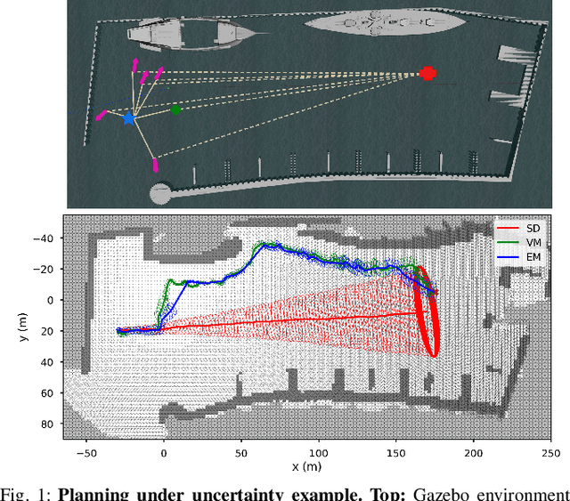
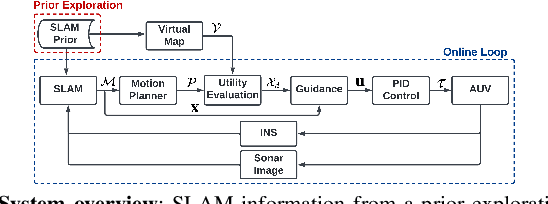
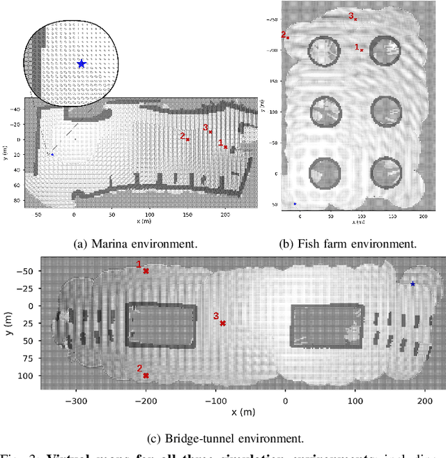
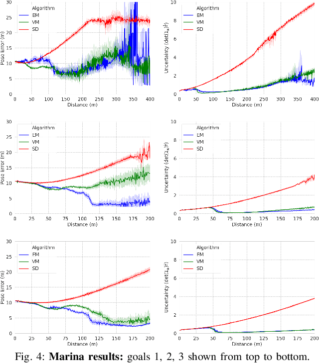
Abstract:Reliable localization is an essential capability for marine robots navigating in GPS-denied environments. SLAM, commonly used to mitigate dead reckoning errors, still fails in feature-sparse environments or with limited-range sensors. Pose estimation can be improved by incorporating the uncertainty prediction of future poses into the planning process and choosing actions that reduce uncertainty. However, performing belief propagation is computationally costly, especially when operating in large-scale environments. This work proposes a computationally efficient planning under uncertainty frame-work suitable for large-scale, feature-sparse environments. Our strategy leverages SLAM graph and occupancy map data obtained from a prior exploration phase to create a virtual map, describing the uncertainty of each map cell using a multivariate Gaussian. The virtual map is then used as a cost map in the planning phase, and performing belief propagation at each step is avoided. A receding horizon planning strategy is implemented, managing a goal-reaching and uncertainty-reduction tradeoff. Simulation experiments in a realistic underwater environment validate this approach. Experimental comparisons against a full belief propagation approach and a standard shortest-distance approach are conducted.
Multi-Robot Autonomous Exploration and Mapping Under Localization Uncertainty with Expectation-Maximization
Mar 06, 2024


Abstract:We propose an autonomous exploration algorithm designed for decentralized multi-robot teams, which takes into account map and localization uncertainties of range-sensing mobile robots. Virtual landmarks are used to quantify the combined impact of process noise and sensor noise on map uncertainty. Additionally, we employ an iterative expectation-maximization inspired algorithm to assess the potential outcomes of both a local robot's and its neighbors' next-step actions. To evaluate the effectiveness of our framework, we conduct a comparative analysis with state-of-the-art algorithms. The results of our experiments show the proposed algorithm's capacity to strike a balance between curbing map uncertainty and achieving efficient task allocation among robots.
Decentralized Multi-Robot Navigation for Autonomous Surface Vehicles with Distributional Reinforcement Learning
Feb 19, 2024


Abstract:Collision avoidance algorithms for Autonomous Surface Vehicles (ASV) that follow the Convention on the International Regulations for Preventing Collisions at Sea (COLREGs) have been proposed in recent years. However, it may be difficult and unsafe to follow COLREGs in congested waters, where multiple ASVs are navigating in the presence of static obstacles and strong currents, due to the complex interactions. To address this problem, we propose a decentralized multi-ASV collision avoidance policy based on Distributional Reinforcement Learning, which considers the interactions among ASVs as well as with static obstacles and current flows. We evaluate the performance of the proposed Distributional RL based policy against a traditional RL-based policy and two classical methods, Artificial Potential Fields (APF) and Reciprocal Velocity Obstacles (RVO), in simulation experiments, which show that the proposed policy achieves superior performance in navigation safety, while requiring minimal travel time and energy. A variant of our framework that automatically adapts its risk sensitivity is also demonstrated to improve ASV safety in highly congested environments.
Mobile Manipulation Platform for Autonomous Indoor Inspections in Low-Clearance Areas
Sep 19, 2023


Abstract:Mobile manipulators have been used for inspection, maintenance and repair tasks over the years, but there are some key limitations. Stability concerns typically require mobile platforms to be large in order to handle far-reaching manipulators, or for the manipulators to have drastically reduced workspaces to fit onto smaller mobile platforms. Therefore we propose a combination of two widely-used robots, the Clearpath Jackal unmanned ground vehicle and the Kinova Gen3 six degree-of-freedom manipulator. The Jackal has a small footprint and works well in low-clearance indoor environments. Extensive testing of localization, navigation and mapping using LiDAR sensors makes the Jackal a well developed mobile platform suitable for mobile manipulation. The Gen3 has a long reach with reasonable power consumption for manipulation tasks. A wrist camera for RGB-D sensing and a customizable end effector interface makes the Gen3 suitable for a myriad of manipulation tasks. Typically these features would result in an unstable platform, however with a few minor hardware and software modifications, we have produced a stable, high-performance mobile manipulation platform with significant mobility, reach, sensing, and maneuverability for indoor inspection tasks, without degradation of the component robots' individual capabilities. These assertions were investigated with hardware via semi-autonomous navigation to waypoints in a busy indoor environment, and high-precision self-alignment alongside planar structures for intervention tasks.
A Robust and Rapidly Deployable Waypoint Navigation Architecture for Long-Duration Operations in GPS-Denied Environments
Aug 10, 2023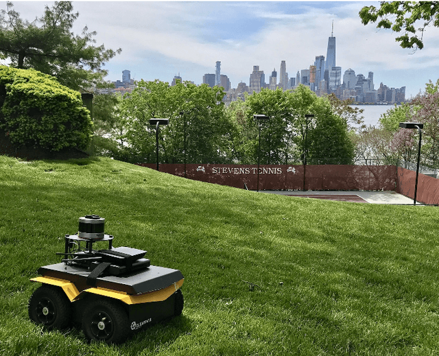
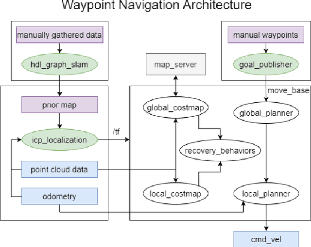
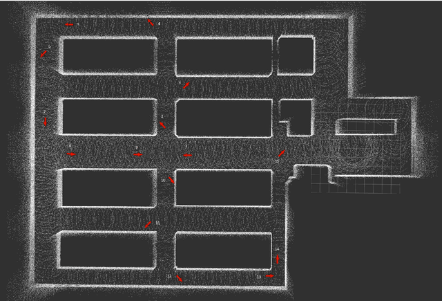
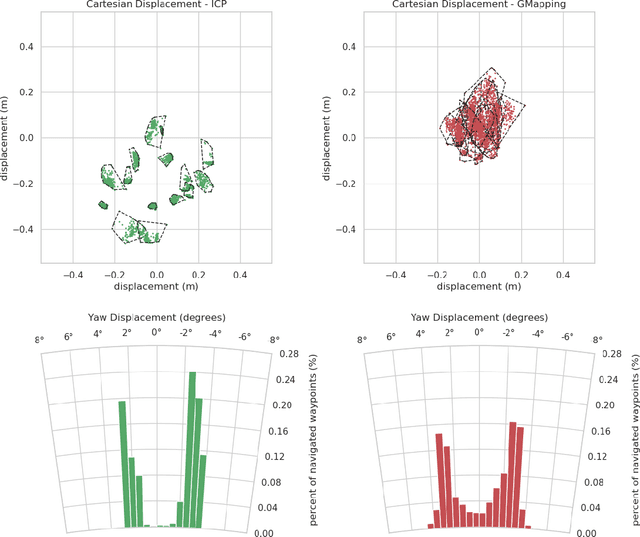
Abstract:For long-duration operations in GPS-denied environments, accurate and repeatable waypoint navigation is an essential capability. While simultaneous localization and mapping (SLAM) works well for single-session operations, repeated, multi-session operations require robots to navigate to the same spot(s) accurately and precisely each and every time. Localization and navigation errors can build up from one session to the next if they are not accounted for. Localization using a global reference map works well, but there are no publicly available packages for quickly building maps and navigating with them. We propose a new architecture using a combination of two publicly available packages with a newly released package to create a fully functional multi-session navigation system for ground vehicles. The system takes just a few hours from the beginning of the first manual scan to perform autonomous waypoint navigation.
Robust Unmanned Surface Vehicle Navigation with Distributional Reinforcement Learning
Jul 30, 2023Abstract:Autonomous navigation of Unmanned Surface Vehicles (USV) in marine environments with current flows is challenging, and few prior works have addressed the sensorbased navigation problem in such environments under no prior knowledge of the current flow and obstacles. We propose a Distributional Reinforcement Learning (RL) based local path planner that learns return distributions which capture the uncertainty of action outcomes, and an adaptive algorithm that automatically tunes the level of sensitivity to the risk in the environment. The proposed planner achieves a more stable learning performance and converges to safer policies than a traditional RL based planner. Computational experiments demonstrate that comparing to a traditional RL based planner and classical local planning methods such as Artificial Potential Fields and the Bug Algorithm, the proposed planner is robust against environmental flows, and is able to plan trajectories that are superior in safety, time and energy consumption.
 Add to Chrome
 Add to Firefox
 Add to Edge