Arash Asgharivaskasi
Riemannian Optimization for Active Mapping with Robot Teams
Apr 28, 2024


Abstract:Autonomous exploration of unknown environments using a team of mobile robots demands distributed perception and planning strategies to enable efficient and scalable performance. Ideally, each robot should update its map and plan its motion not only relying on its own observations, but also considering the observations of its peers. Centralized solutions to multi-robot coordination are susceptible to central node failure and require a sophisticated communication infrastructure for reliable operation. Current decentralized active mapping methods consider simplistic robot models with linear-Gaussian observations and Euclidean robot states. In this work, we present a distributed multi-robot mapping and planning method, called Riemannian Optimization for Active Mapping (ROAM). We formulate an optimization problem over a graph with node variables belonging to a Riemannian manifold and a consensus constraint requiring feasible solutions to agree on the node variables. We develop a distributed Riemannian optimization algorithm that relies only on one-hop communication to solve the problem with consensus and optimality guarantees. We show that multi-robot active mapping can be achieved via two applications of our distributed Riemannian optimization over different manifolds: distributed estimation of a 3-D semantic map and distributed planning of SE(3) trajectories that minimize map uncertainty. We demonstrate the performance of ROAM in simulation and real-world experiments using a team of robots with RGB-D cameras.
Distributed Optimization with Consensus Constraint for Multi-Robot Semantic Octree Mapping
Feb 14, 2024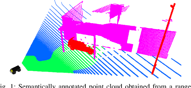
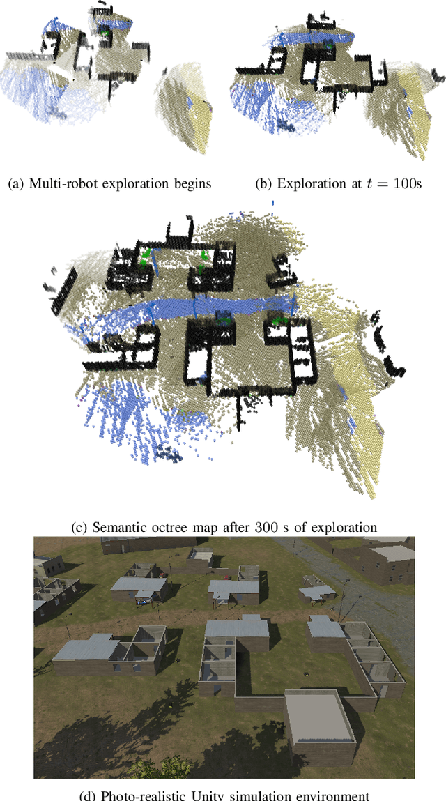
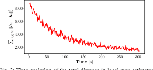
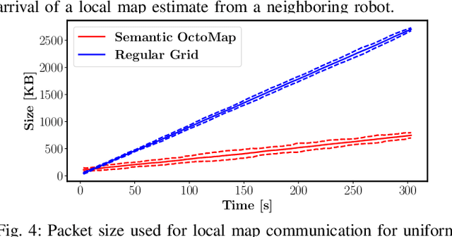
Abstract:This work develops a distributed optimization algorithm for multi-robot 3-D semantic mapping using streaming range and visual observations and single-hop communication. Our approach relies on gradient-based optimization of the observation log-likelihood of each robot subject to a map consensus constraint to build a common multi-class map of the environment. This formulation leads to closed-form updates which resemble Bayes rule with one-hop prior averaging. To reduce the amount of information exchanged among the robots, we utilize an octree data structure that compresses the multi-class map distribution using adaptive-resolution.
Optimal Scene Graph Planning with Large Language Model Guidance
Sep 17, 2023


Abstract:Recent advances in metric, semantic, and topological mapping have equipped autonomous robots with semantic concept grounding capabilities to interpret natural language tasks. This work aims to leverage these new capabilities with an efficient task planning algorithm for hierarchical metric-semantic models. We consider a scene graph representation of the environment and utilize a large language model (LLM) to convert a natural language task into a linear temporal logic (LTL) automaton. Our main contribution is to enable optimal hierarchical LTL planning with LLM guidance over scene graphs. To achieve efficiency, we construct a hierarchical planning domain that captures the attributes and connectivity of the scene graph and the task automaton, and provide semantic guidance via an LLM heuristic function. To guarantee optimality, we design an LTL heuristic function that is provably consistent and supplements the potentially inadmissible LLM guidance in multi-heuristic planning. We demonstrate efficient planning of complex natural language tasks in scene graphs of virtualized real environments.
Policy Learning for Active Target Tracking over Continuous SE(3) Trajectories
Dec 03, 2022

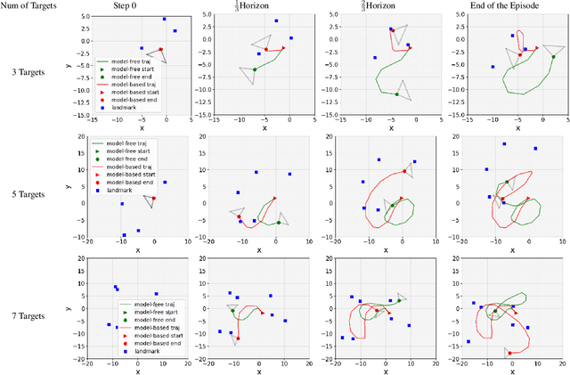
Abstract:This paper proposes a novel model-based policy gradient algorithm for tracking dynamic targets using a mobile robot, equipped with an onboard sensor with limited field of view. The task is to obtain a continuous control policy for the mobile robot to collect sensor measurements that reduce uncertainty in the target states, measured by the target distribution entropy. We design a neural network control policy with the robot $SE(3)$ pose and the mean vector and information matrix of the joint target distribution as inputs and attention layers to handle variable numbers of targets. We also derive the gradient of the target entropy with respect to the network parameters explicitly, allowing efficient model-based policy gradient optimization.
Learning Continuous Control Policies for Information-Theoretic Active Perception
Sep 26, 2022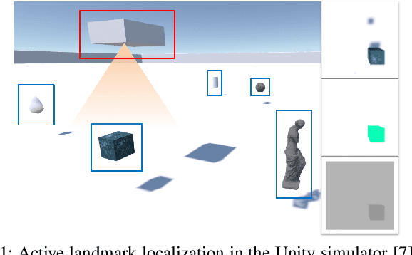
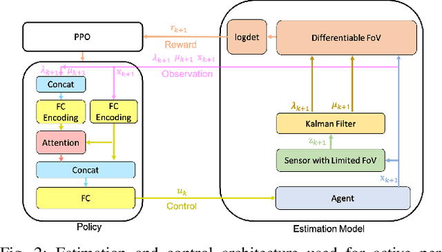

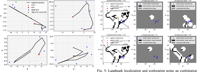
Abstract:This paper proposes a method for learning continuous control policies for active landmark localization and exploration using an information-theoretic cost. We consider a mobile robot detecting landmarks within a limited sensing range, and tackle the problem of learning a control policy that maximizes the mutual information between the landmark states and the sensor observations. We employ a Kalman filter to convert the partially observable problem in the landmark state to Markov decision process (MDP), a differentiable field of view to shape the reward, and an attention-based neural network to represent the control policy. The approach is further unified with active volumetric mapping to promote exploration in addition to landmark localization. The performance is demonstrated in several simulated landmark localization tasks in comparison with benchmark methods.
Information-theoretic Abstraction of Semantic Octree Models for Integrated Perception and Planning
Sep 20, 2022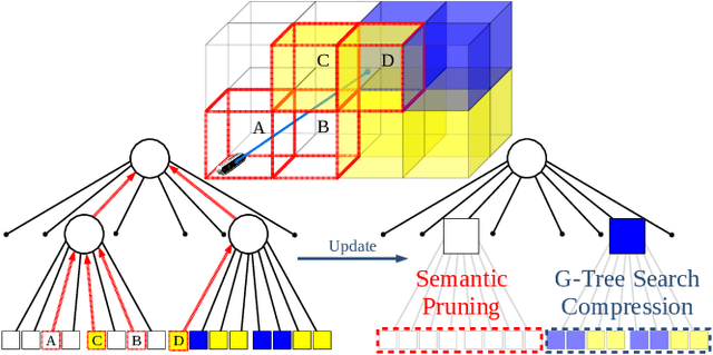

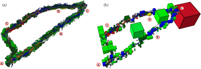
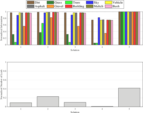
Abstract:In this paper, we develop an approach that enables autonomous robots to build and compress semantic environment representations from point-cloud data. Our approach builds a three-dimensional, semantic tree representation of the environment from sensor data which is then compressed by a novel information-theoretic tree-pruning approach. The proposed approach is probabilistic and incorporates the uncertainty in semantic classification inherent in real-world environments. Moreover, our approach allows robots to prioritize individual semantic classes when generating the compressed trees, so as to design multi-resolution representations that retain the relevant semantic information while simultaneously discarding unwanted semantic categories. We demonstrate the approach by compressing semantic octree models of a large outdoor, semantically rich, real-world environment. In addition, we show how the octree abstractions can be used to create semantically-informed graphs for motion planning, and provide a comparison of our approach with uninformed graph construction methods such as Halton sequences.
Active Mapping via Gradient Ascent Optimization of Shannon Mutual Information over Continuous SE(3) Trajectories
Apr 15, 2022


Abstract:The problem of active mapping aims to plan an informative sequence of sensing views given a limited budget such as distance traveled. This paper consider active occupancy grid mapping using a range sensor, such as LiDAR or depth camera. State-of-the-art methods optimize information-theoretic measures relating the occupancy grid probabilities with the range sensor measurements. The non-smooth nature of ray-tracing within a grid representation makes the objective function non-differentiable, forcing existing methods to search over a discrete space of candidate trajectories. This work proposes a differentiable approximation of the Shannon mutual information between a grid map and ray-based observations that enables gradient ascent optimization in the continuous space of SE(3) sensor poses. Our gradient-based formulation leads to more informative sensing trajectories, while avoiding occlusions and collisions. The proposed method is demonstrated in simulated and real-world experiments in 2-D and 3-D environments.
Active Bayesian Multi-class Mapping from Range and Semantic Segmentation Observations
Dec 08, 2021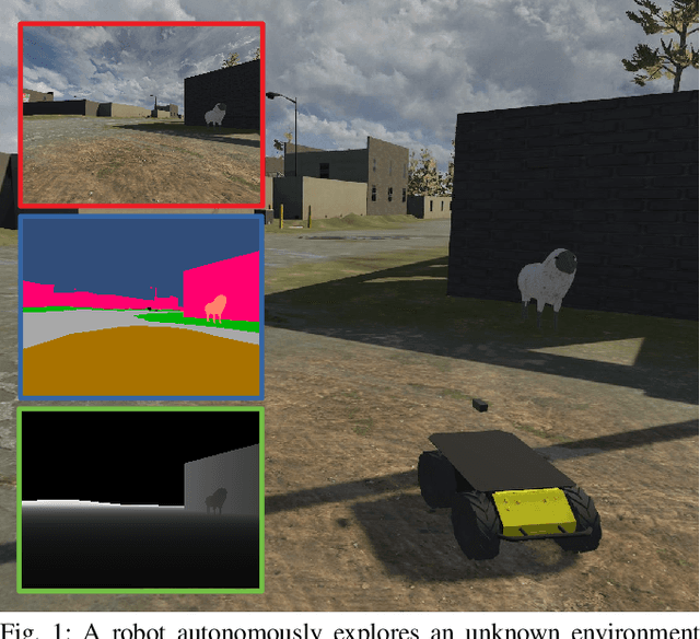
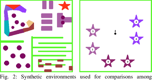
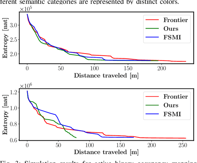
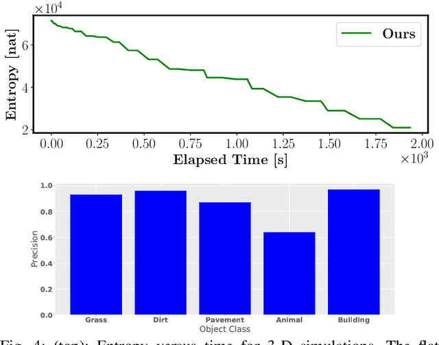
Abstract:The demand for robot exploration in unstructured and unknown environments has recently grown substantially thanks to the host of inexpensive sensing and edge-computing solutions. In order to come closer to full autonomy, robots need to process the measurement stream in real-time, which calls for efficient exploration strategies. Information-based exploration techniques, such as Cauchy-Schwarz quadratic mutual information (CSQMI) and fast Shannon mutual information (FSMI), have successfully achieved active binary occupancy mapping with range measurements. However, as we envision robots performing complex tasks specified with semantically meaningful objects, it is necessary to capture semantic categories in the measurements, map representation, and exploration objective. In this work we propose a Bayesian multi-class mapping algorithm utilizing range-category measurements, as well as a closed-form efficiently computable lower bound for the Shannon mutual information between the multi-class map and the measurements. The bound allows rapid evaluation of many potential robot trajectories for autonomous exploration and mapping. Furthermore, we develop a compressed representation of 3-D environments with semantic labels based on OcTree data structure, where each voxel maintains a categorical distribution over object classes. The proposed 3-D representation facilitates fast computation of Shannon mutual information between the semantic Octomap and the measurements using Run-Length Encoding (RLE) of range-category observation rays. We compare our method against frontier-based and FSMI exploration and apply it in a variety of simulated and real-world experiments.
Active SLAM over Continuous Trajectory and Control: A Covariance-Feedback Approach
Oct 14, 2021


Abstract:This paper proposes a novel active Simultaneous Localization and Mapping (SLAM) method with continuous trajectory optimization over a stochastic robot dynamics model. The problem is formalized as a stochastic optimal control over the continuous robot kinematic model to minimize a cost function that involves the covariance matrix of the landmark states. We tackle the problem by separately obtaining an open-loop control sequence subject to deterministic dynamics by iterative Covariance Regulation (iCR) and a closed-loop feedback control under stochastic robot and covariance dynamics by Linear Quadratic Regulator (LQR). The proposed optimization method captures the coupling between localization and mapping in predicting uncertainty evolution and synthesizes highly informative sensing trajectories. We demonstrate its performance in active landmark-based SLAM using relative-position measurements with a limited field of view.
Active Exploration and Mapping via Iterative Covariance Regulation over Continuous $SE(3)$ Trajectories
Mar 10, 2021


Abstract:This paper develops \emph{iterative Covariance Regulation} (iCR), a novel method for active exploration and mapping for a mobile robot equipped with on-board sensors. The problem is posed as optimal control over the $SE(3)$ pose kinematics of the robot to minimize the differential entropy of the map conditioned the potential sensor observations. We introduce a differentiable field of view formulation, and derive iCR via the gradient descent method to iteratively update an open-loop control sequence in continuous space so that the covariance of the map estimate is minimized. We demonstrate autonomous exploration and uncertainty reduction in simulated occupancy grid environments.
 Add to Chrome
 Add to Firefox
 Add to Edge