Adway Mitra
Deep Learning for Slum Mapping in Remote Sensing Images: A Meta-analysis and Review
Jun 12, 2024Abstract:The major Sustainable Development Goals (SDG) 2030, set by the United Nations Development Program (UNDP), include sustainable cities and communities, no poverty, and reduced inequalities. However, millions of people live in slums or informal settlements with poor living conditions in many major cities around the world, especially in less developed countries. To emancipate these settlements and their inhabitants through government intervention, accurate data about slum location and extent is required. While ground survey data is the most reliable, such surveys are costly and time-consuming. An alternative is remotely sensed data obtained from very high-resolution (VHR) imagery. With the advancement of new technology, remote sensing based mapping of slums has emerged as a prominent research area. The parallel rise of Artificial Intelligence, especially Deep Learning has added a new dimension to this field as it allows automated analysis of satellite imagery to identify complex spatial patterns associated with slums. This article offers a detailed review and meta-analysis of research on slum mapping using remote sensing imagery from 2014 to 2024, with a special focus on deep learning approaches. Our analysis reveals a trend towards increasingly complex neural network architectures, with advancements in data preprocessing and model training techniques significantly enhancing slum identification accuracy. We have attempted to identify key methodologies that are effective across diverse geographic contexts. While acknowledging the transformative impact Convolutional Neural Networks (CNNs) in slum detection, our review underscores the absence of a universally optimal model, suggesting the need for context-specific adaptations. We also identify prevailing challenges in this field, such as data limitations and a lack of model explainability and suggest potential strategies for overcoming these.
SepHRNet: Generating High-Resolution Crop Maps from Remote Sensing imagery using HRNet with Separable Convolution
Jul 11, 2023Abstract:The accurate mapping of crop production is crucial for ensuring food security, effective resource management, and sustainable agricultural practices. One way to achieve this is by analyzing high-resolution satellite imagery. Deep Learning has been successful in analyzing images, including remote sensing imagery. However, capturing intricate crop patterns is challenging due to their complexity and variability. In this paper, we propose a novel Deep learning approach that integrates HRNet with Separable Convolutional layers to capture spatial patterns and Self-attention to capture temporal patterns of the data. The HRNet model acts as a backbone and extracts high-resolution features from crop images. Spatially separable convolution in the shallow layers of the HRNet model captures intricate crop patterns more effectively while reducing the computational cost. The multi-head attention mechanism captures long-term temporal dependencies from the encoded vector representation of the images. Finally, a CNN decoder generates a crop map from the aggregated representation. Adaboost is used on top of this to further improve accuracy. The proposed algorithm achieves a high classification accuracy of 97.5\% and IoU of 55.2\% in generating crop maps. We evaluate the performance of our pipeline on the Zuericrop dataset and demonstrate that our results outperform state-of-the-art models such as U-Net++, ResNet50, VGG19, InceptionV3, DenseNet, and EfficientNet. This research showcases the potential of Deep Learning for Earth Observation Systems.
Deep Learning-based Spatially Explicit Emulation of an Agent-Based Simulator for Pandemic in a City
May 28, 2022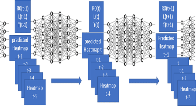

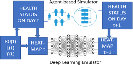

Abstract:Agent-Based Models are very useful for simulation of physical or social processes, such as the spreading of a pandemic in a city. Such models proceed by specifying the behavior of individuals (agents) and their interactions, and parameterizing the process of infection based on such interactions based on the geography and demography of the city. However, such models are computationally very expensive, and the complexity is often linear in the total number of agents. This seriously limits the usage of such models for simulations, which often have to be run hundreds of times for policy planning and even model parameter estimation. An alternative is to develop an emulator, a surrogate model that can predict the Agent-Based Simulator's output based on its initial conditions and parameters. In this paper, we discuss a Deep Learning model based on Dilated Convolutional Neural Network that can emulate such an agent based model with high accuracy. We show that use of this model instead of the original Agent-Based Model provides us major gains in the speed of simulations, allowing much quicker calibration to observations, and more extensive scenario analysis. The models we consider are spatially explicit, as the locations of the infected individuals are simulated instead of the gross counts. Another aspect of our emulation framework is its divide-and-conquer approach that divides the city into several small overlapping blocks and carries out the emulation in them parallelly, after which these results are merged together. This ensures that the same emulator can work for a city of any size, and also provides significant improvement of time complexity of the emulator, compared to the original simulator.
Spatio-temporal relationships between rainfall and convective clouds during Indian Monsoon through a discrete lens
Aug 19, 2020


Abstract:The Indian monsoon, a multi-variable process causing heavy rains during June-September every year, is very heterogeneous in space and time. We study the relationship between rainfall and Outgoing Longwave Radiation (OLR, convective cloud cover) for monsoon between 2004-2010. To identify, classify and visualize spatial patterns of rainfall and OLR we use a discrete and spatio-temporally coherent representation of the data, created using a statistical model based on Markov Random Field. Our approach clusters the days with similar spatial distributions of rainfall and OLR into a small number of spatial patterns. We find that eight daily spatial patterns each in rainfall and OLR, and seven joint patterns of rainfall and OLR, describe over 90\% of all days. Through these patterns, we find that OLR generally has a strong negative correlation with precipitation, but with significant spatial variations. In particular, peninsular India (except west coast) is under significant convective cloud cover over a majority of days but remains rainless. We also find that much of the monsoon rainfall co-occurs with low OLR, but some amount of rainfall in Eastern and North-western India in June occurs on OLR days, presumably from shallow clouds. To study day-to-day variations of both quantities, we identify spatial patterns in the temporal gradients computed from the observations. We find that changes in convective cloud activity across India most commonly occur due to the establishment of a north-south OLR gradient which persists for 1-2 days and shifts the convective cloud cover from light to deep or vice versa. Such changes are also accompanied by changes in the spatial distribution of precipitation. The present work thus provides a highly reduced description of the complex spatial patterns and their day-to-day variations, and could form a useful tool for future simplified descriptions of this process.
Electoral David vs Goliath: How does the Spatial Concentration of Electors affect District-based Elections?
Jun 21, 2020
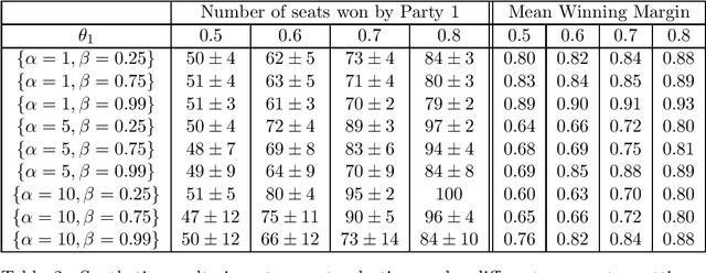
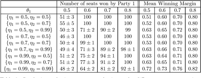
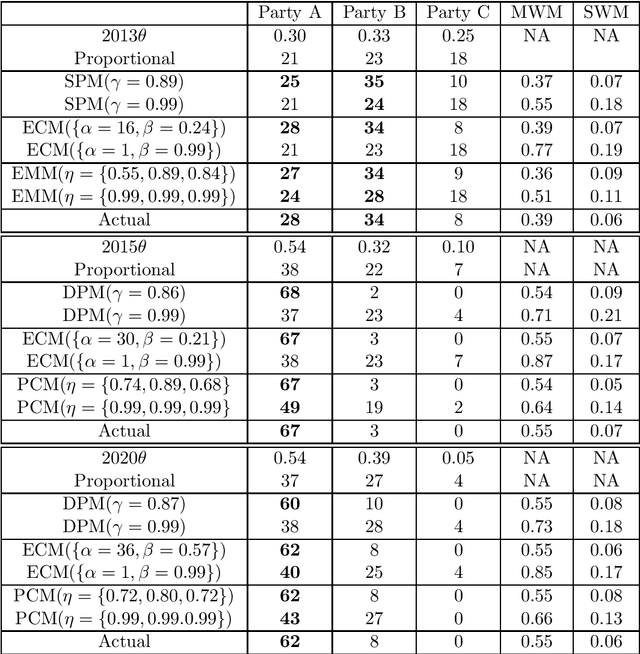
Abstract:Many democratic countries use district-based elections where there is a "seat" for each district in the governing body. In each district, the party whose candidate gets the maximum number of votes wins the corresponding seat. The result of the election is decided based on the number of seats won by the different parties. The electors (voters) can cast their votes only in the district of their residence. Thus, locations of the electors and boundaries of the districts may severely affect the election result even if the proportion of popular support (number of electors) of different parties remains unchanged. This has led to significant amount of research on whether the districts may be redrawn or electors may be moved to maximize seats for a particular party. In this paper, we frame the spatial distribution of electors in a probabilistic setting, and explore different models to capture the intra-district polarization of electors in favour of a party, or the spatial concentration of supporters of different parties. Our models are inspired by elections in India, where supporters of different parties tend to be concentrated in certain districts. We show with extensive simulations that our model can capture different statistical properties of real elections held in India. We frame parameter estimation problems to fit our models to the observed election results. Since analytical calculation of the likelihood functions are infeasible for our complex models, we use Likelihood-free Inference methods under the Approximate Bayesian Computation framework. Since this approach is highly time-consuming, we explore how supervised regression using Logistic Regression or Deep Neural Networks can be used to speed it up. We also explore how the election results can change by varying the spatial distributions of the voters, even when the proportions of popular support of the parties remain constant.
Video Trajectory Classification and Anomaly Detection Using Hybrid CNN-VAE
Dec 18, 2018
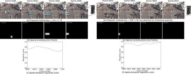
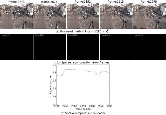

Abstract:Classifying time series data using neural networks is a challenging problem when the length of the data varies. Video object trajectories, which are key to many of the visual surveillance applications, are often found to be of varying length. If such trajectories are used to understand the behavior (normal or anomalous) of moving objects, they need to be represented correctly. In this paper, we propose video object trajectory classification and anomaly detection using a hybrid Convolutional Neural Network (CNN) and Variational Autoencoder (VAE) architecture. First, we introduce a high level representation of object trajectories using color gradient form. In the next stage, a semi-supervised way to annotate moving object trajectories extracted using Temporal Unknown Incremental Clustering (TUIC), has been applied for trajectory class labeling. Anomalous trajectories are separated using t-Distributed Stochastic Neighbor Embedding (t-SNE). Finally, a hybrid CNN-VAE architecture has been used for trajectory classification and anomaly detection. The results obtained using publicly available surveillance video datasets reveal that the proposed method can successfully identify some of the important traffic anomalies such as vehicles not following lane driving, sudden speed variations, abrupt termination of vehicle movement, and vehicles moving in wrong directions. The proposed method is able to detect above anomalies at higher accuracy as compared to existing anomaly detection methods.
Exploring Bayesian Models for Multi-level Clustering of Hierarchically Grouped Sequential Data
Apr 19, 2015


Abstract:A wide range of Bayesian models have been proposed for data that is divided hierarchically into groups. These models aim to cluster the data at different levels of grouping, by assigning a mixture component to each datapoint, and a mixture distribution to each group. Multi-level clustering is facilitated by the sharing of these components and distributions by the groups. In this paper, we introduce the concept of Degree of Sharing (DoS) for the mixture components and distributions, with an aim to analyze and classify various existing models. Next we introduce a generalized hierarchical Bayesian model, of which the existing models can be shown to be special cases. Unlike most of these models, our model takes into account the sequential nature of the data, and various other temporal structures at different levels while assigning mixture components and distributions. We show one specialization of this model aimed at hierarchical segmentation of news transcripts, and present a Gibbs Sampling based inference algorithm for it. We also show experimentally that the proposed model outperforms existing models for the same task.
Temporally Coherent Bayesian Models for Entity Discovery in Videos by Tracklet Clustering
Feb 06, 2015


Abstract:A video can be represented as a sequence of tracklets, each spanning 10-20 frames, and associated with one entity (eg. a person). The task of \emph{Entity Discovery} in videos can be naturally posed as tracklet clustering. We approach this task by leveraging \emph{Temporal Coherence}(TC): the fundamental property of videos that each tracklet is likely to be associated with the same entity as its temporal neighbors. Our major contributions are the first Bayesian nonparametric models for TC at tracklet-level. We extend Chinese Restaurant Process (CRP) to propose TC-CRP, and further to Temporally Coherent Chinese Restaurant Franchise (TC-CRF) to jointly model short temporal segments. On the task of discovering persons in TV serial videos without meta-data like scripts, these methods show considerable improvement in cluster purity and person coverage compared to state-of-the-art approaches to tracklet clustering. We represent entities with mixture components, and tracklets with vectors of very generic features, which can work for any type of entity (not necessarily person). The proposed methods can perform online tracklet clustering on streaming videos with little performance deterioration unlike existing approaches, and can automatically reject tracklets resulting from false detections. Finally we discuss entity-driven video summarization- where some temporal segments of the video are selected automatically based on the discovered entities.
 Add to Chrome
 Add to Firefox
 Add to Edge