Zhengwei Bai
Cooperverse: A Mobile-Edge-Cloud Framework for Universal Cooperative Perception with Mixed Connectivity and Automation
Feb 06, 2023Abstract:Cooperative perception (CP) is attracting increasing attention and is regarded as the core foundation to support cooperative driving automation, a potential key solution to addressing the safety, mobility, and sustainability issues of contemporary transportation systems. However, current research on CP is still at the beginning stages where a systematic problem formulation of CP is still missing, acting as the essential guideline of the system design of a CP system under real-world situations. In this paper, we formulate a universal CP system into an optimization problem and a mobile-edge-cloud framework called Cooperverse. This system addresses CP in a mixed connectivity and automation environment. A Dynamic Feature Sharing (DFS) methodology is introduced to support this CP system under certain constraints and a Random Priority Filtering (RPF) method is proposed to conduct DFS with high performance. Experiments have been conducted based on a high-fidelity CP platform, and the results show that the Cooperverse framework is effective for dynamic node engagement and the proposed DFS methodology can improve system CP performance by 14.5% and the RPF method can reduce the communication cost for mobile nodes by 90% with only 1.7% drop for average precision.
VINet: Lightweight, Scalable, and Heterogeneous Cooperative Perception for 3D Object Detection
Dec 14, 2022


Abstract:Utilizing the latest advances in Artificial Intelligence (AI), the computer vision community is now witnessing an unprecedented evolution in all kinds of perception tasks, particularly in object detection. Based on multiple spatially separated perception nodes, Cooperative Perception (CP) has emerged to significantly advance the perception of automated driving. However, current cooperative object detection methods mainly focus on ego-vehicle efficiency without considering the practical issues of system-wide costs. In this paper, we introduce VINet, a unified deep learning-based CP network for scalable, lightweight, and heterogeneous cooperative 3D object detection. VINet is the first CP method designed from the standpoint of large-scale system-level implementation and can be divided into three main phases: 1) Global Pre-Processing and Lightweight Feature Extraction which prepare the data into global style and extract features for cooperation in a lightweight manner; 2) Two-Stream Fusion which fuses the features from scalable and heterogeneous perception nodes; and 3) Central Feature Backbone and 3D Detection Head which further process the fused features and generate cooperative detection results. A cooperative perception platform is designed and developed for CP dataset acquisition and several baselines are compared during the experiments. The experimental analysis shows that VINet can achieve remarkable improvements for pedestrians and cars with 2x less system-wide computational costs and 12x less system-wide communicational costs.
A Survey and Framework of Cooperative Perception: From Heterogeneous Singleton to Hierarchical Cooperation
Aug 22, 2022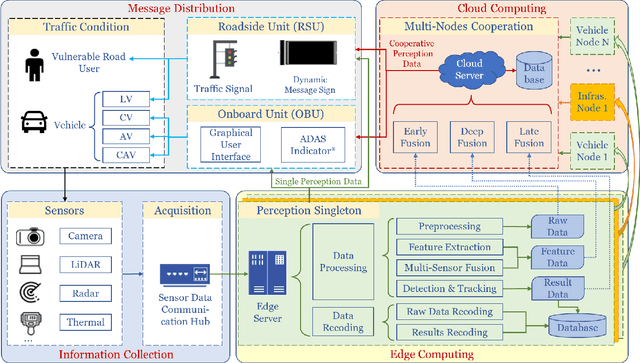
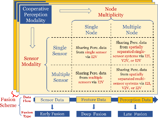
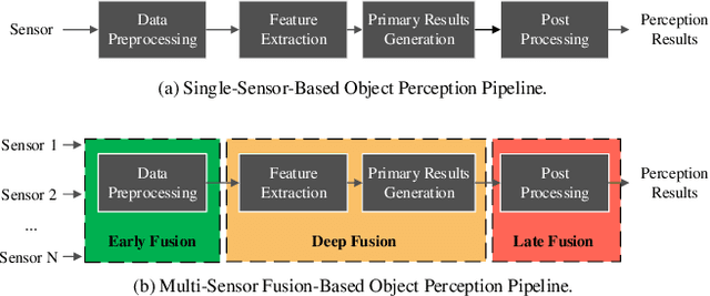
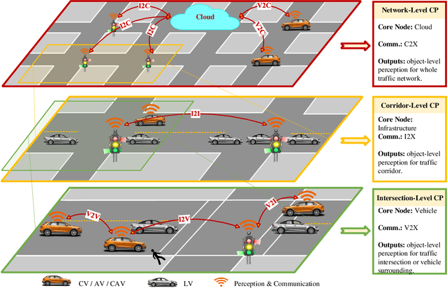
Abstract:Perceiving the environment is one of the most fundamental keys to enabling Cooperative Driving Automation (CDA), which is regarded as the revolutionary solution to addressing the safety, mobility, and sustainability issues of contemporary transportation systems. Although an unprecedented evolution is now happening in the area of computer vision for object perception, state-of-the-art perception methods are still struggling with sophisticated real-world traffic environments due to the inevitably physical occlusion and limited receptive field of single-vehicle systems. Based on multiple spatially separated perception nodes, Cooperative Perception (CP) is born to unlock the bottleneck of perception for driving automation. In this paper, we comprehensively review and analyze the research progress on CP and, to the best of our knowledge, this is the first time to propose a unified CP framework. Architectures and taxonomy of CP systems based on different types of sensors are reviewed to show a high-level description of the workflow and different structures for CP systems. Node structure, sensor modality, and fusion schemes are reviewed and analyzed with comprehensive literature to provide detailed explanations of specific methods. A Hierarchical CP framework is proposed, followed by a review of existing Datasets and Simulators to sketch an overall landscape of CP. Discussion highlights the current opportunities, open challenges, and anticipated future trends.
Cyber Mobility Mirror: A Deep Learning-based Real-World Object Perception Platform Using Roadside LiDAR
Apr 07, 2022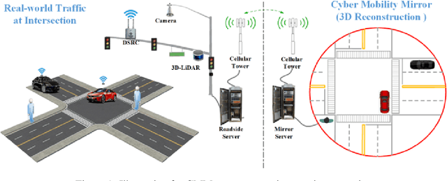
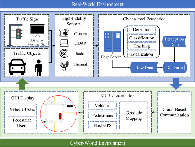
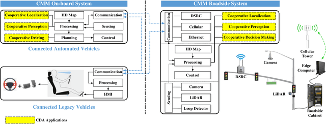
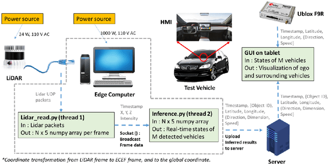
Abstract:Object perception plays a fundamental role in Cooperative Driving Automation (CDA) which is regarded as a revolutionary promoter for the next-generation transportation systems. However, the vehicle-based perception may suffer from the limited sensing range and occlusion as well as low penetration rates in connectivity. In this paper, we propose Cyber Mobility Mirror (CMM), a next-generation real-time traffic surveillance system for 3D object perception and reconstruction, to explore the potential of roadside sensors for enabling CDA in the real world. The CMM system consists of six main components: 1) the data pre-processor to retrieve and preprocess the raw data; 2) the roadside 3D object detector to generate 3D detection results; 3) the multi-object tracker to identify detected objects; 4) the global locator to map positioning information from the LiDAR coordinate to geographic coordinate using coordinate transformation; 5) the cloud-based communicator to transmit perception information from roadside sensors to equipped vehicles, and 6) the onboard advisor to reconstruct and display the real-time traffic conditions via Graphical User Interface (GUI). In this study, a field-operational system is deployed at a real-world intersection, University Avenue and Iowa Avenue in Riverside, California to assess the feasibility and performance of our CMM system. Results from field tests demonstrate that our CMM prototype system can provide satisfactory perception performance with 96.99% precision and 83.62% recall. High-fidelity real-time traffic conditions (at the object level) can be geo-localized with an average error of 0.14m and displayed on the GUI of the equipped vehicle with a frequency of 3-4 Hz.
PillarGrid: Deep Learning-based Cooperative Perception for 3D Object Detection from Onboard-Roadside LiDAR
Mar 19, 2022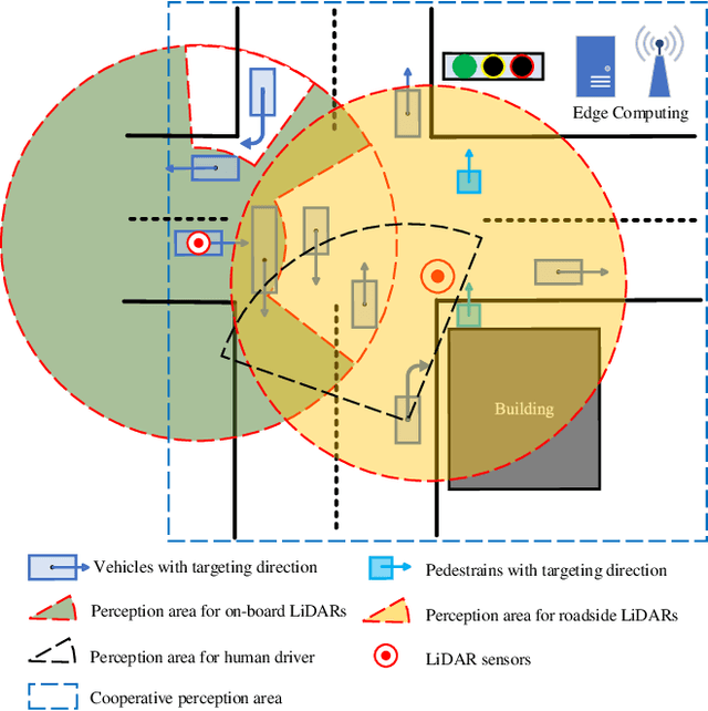

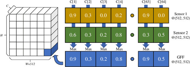

Abstract:3D object detection plays a fundamental role in enabling autonomous driving, which is regarded as the significant key to unlocking the bottleneck of contemporary transportation systems from the perspectives of safety, mobility, and sustainability. Most of the state-of-the-art (SOTA) object detection methods from point clouds are developed based on a single onboard LiDAR, whose performance will be inevitably limited by the range and occlusion, especially in dense traffic scenarios. In this paper, we propose \textit{PillarGrid}, a novel cooperative perception method fusing information from multiple 3D LiDARs (both on-board and roadside), to enhance the situation awareness for connected and automated vehicles (CAVs). PillarGrid consists of four main phases: 1) cooperative preprocessing of point clouds, 2) pillar-wise voxelization and feature extraction, 3) grid-wise deep fusion of features from multiple sensors, and 4) convolutional neural network (CNN)-based augmented 3D object detection. A novel cooperative perception platform is developed for model training and testing. Extensive experimentation shows that PillarGrid outperforms the SOTA single-LiDAR-based 3D object detection methods with respect to both accuracy and range by a large margin.
Spatiotemporal Transformer Attention Network for 3D Voxel Level Joint Segmentation and Motion Prediction in Point Cloud
Feb 28, 2022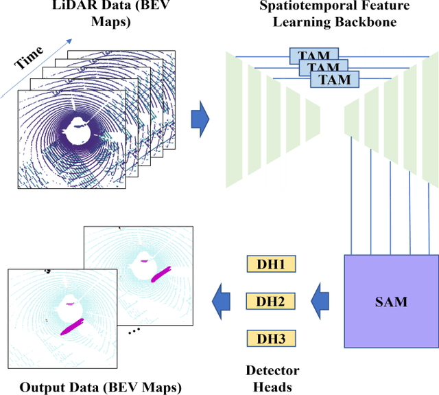
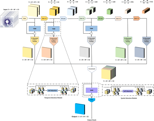

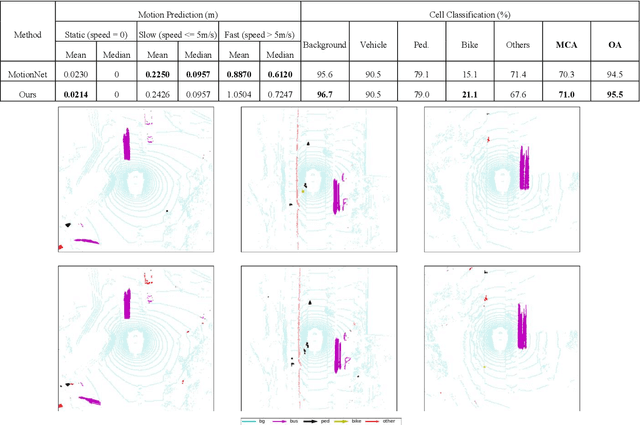
Abstract:Environment perception including detection, classification, tracking, and motion prediction are key enablers for automated driving systems and intelligent transportation applications. Fueled by the advances in sensing technologies and machine learning techniques, LiDAR-based sensing systems have become a promising solution. The current challenges of this solution are how to effectively combine different perception tasks into a single backbone and how to efficiently learn the spatiotemporal features directly from point cloud sequences. In this research, we propose a novel spatiotemporal attention network based on a transformer self-attention mechanism for joint semantic segmentation and motion prediction within a point cloud at the voxel level. The network is trained to simultaneously outputs the voxel level class and predicted motion by learning directly from a sequence of point cloud datasets. The proposed backbone includes both a temporal attention module (TAM) and a spatial attention module (SAM) to learn and extract the complex spatiotemporal features. This approach has been evaluated with the nuScenes dataset, and promising performance has been achieved.
Hybrid Reinforcement Learning-Based Eco-Driving Strategy for Connected and Automated Vehicles at Signalized Intersections
Jan 28, 2022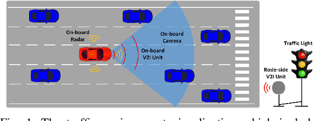
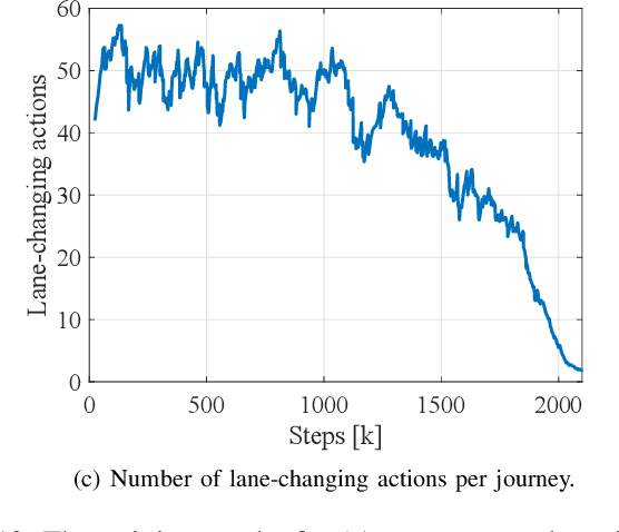
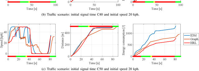
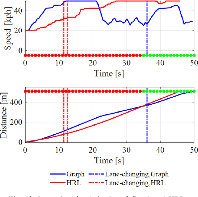
Abstract:Taking advantage of both vehicle-to-everything (V2X) communication and automated driving technology, connected and automated vehicles are quickly becoming one of the transformative solutions to many transportation problems. However, in a mixed traffic environment at signalized intersections, it is still a challenging task to improve overall throughput and energy efficiency considering the complexity and uncertainty in the traffic system. In this study, we proposed a hybrid reinforcement learning (HRL) framework which combines the rule-based strategy and the deep reinforcement learning (deep RL) to support connected eco-driving at signalized intersections in mixed traffic. Vision-perceptive methods are integrated with vehicle-to-infrastructure (V2I) communications to achieve higher mobility and energy efficiency in mixed connected traffic. The HRL framework has three components: a rule-based driving manager that operates the collaboration between the rule-based policies and the RL policy; a multi-stream neural network that extracts the hidden features of vision and V2I information; and a deep RL-based policy network that generate both longitudinal and lateral eco-driving actions. In order to evaluate our approach, we developed a Unity-based simulator and designed a mixed-traffic intersection scenario. Moreover, several baselines were implemented to compare with our new design, and numerical experiments were conducted to test the performance of the HRL model. The experiments show that our HRL method can reduce energy consumption by 12.70% and save 11.75% travel time when compared with a state-of-the-art model-based Eco-Driving approach.
Infrastructure-Based Object Detection and Tracking for Cooperative Driving Automation: A Survey
Jan 28, 2022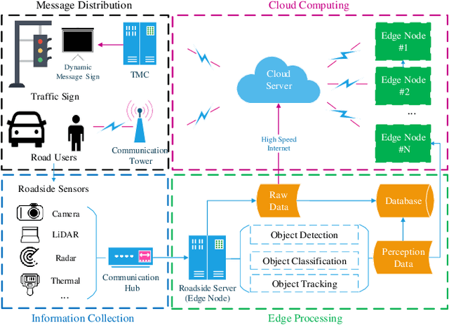
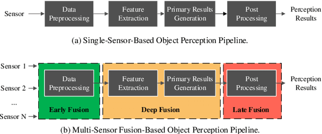

Abstract:Object detection plays a fundamental role in enabling Cooperative Driving Automation (CDA), which is regarded as the revolutionary solution to addressing safety, mobility, and sustainability issues of contemporary transportation systems. Although current computer vision technologies could provide satisfactory object detection results in occlusion-free scenarios, the perception performance of onboard sensors could be inevitably limited by the range and occlusion. Owing to flexible position and pose for sensor installation, infrastructure-based detection and tracking systems can enhance the perception capability for connected vehicles and thus quickly become one of the most popular research topics. In this paper, we review the research progress for infrastructure-based object detection and tracking systems. Architectures of roadside perception systems based on different types of sensors are reviewed to show a high-level description of the workflows for infrastructure-based perception systems. Roadside sensors and different perception methodologies are reviewed and analyzed with detailed literature to provide a low-level explanation for specific methods followed by Datasets and Simulators to draw an overall landscape of infrastructure-based object detection and tracking methods. Discussions are conducted to point out current opportunities, open problems, and anticipated future trends.
Cyber Mobility Mirror for Enabling Cooperative Driving Automation: A Co-Simulation Platform
Jan 24, 2022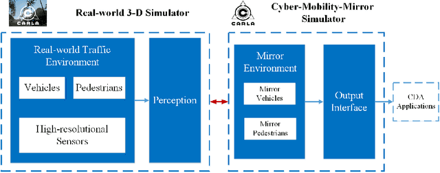
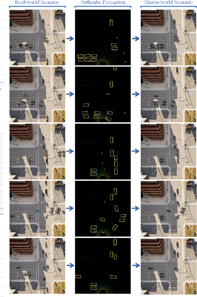
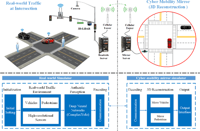
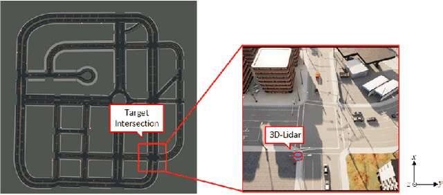
Abstract:Endowed with automation and connectivity, Connected and Automated Vehicles (CAVs) are meant to be a revolutionary promoter for Cooperative Driving Automation (CDA). Nevertheless, CAVs need high-fidelity perception information on their surroundings, which is available but costly to collect from various on-board sensors, such as radar, camera, and LiDAR, as well as vehicle-to-everything (V2X) communications. Therefore, precisely simulating the sensing process with high-fidelity sensor inputs and timely retrieving the perception information via a cost-effective platform are of increasing significance for enabling CDA-related research, e.g., development of decision-making or control module. Most state-of-the-art traffic simulation studies for CAVs rely on the situation-awareness information by directly calling on intrinsic attributes of the objects, which impedes the reliability and fidelity for testing and validation of CDA algorithms. In this study, a co-simulation platform is developed, which can simulate both the real world with a high-fidelity sensor perception system and the cyber world (or "mirror" world) with a real-time 3D reconstruction system. Specifically, the real-world simulator is mainly in charge of simulating the road-users (such as vehicles, bicyclists, and pedestrians), infrastructure (e.g., traffic signals and roadside sensors) as well as the object detection process. The mirror-world simulator is responsible for reconstructing 3D objects and their trajectories from the perceived information (provided by those roadside sensors in the real-world simulator) to support the development and evaluation of CDA algorithms. To illustrate the efficacy of this co-simulation platform, a roadside LiDAR-based real-time vehicle detection and 3D reconstruction system is prototyped as a study case.
Deep Learning Based Motion Planning For Autonomous Vehicle Using Spatiotemporal LSTM Network
Mar 05, 2019
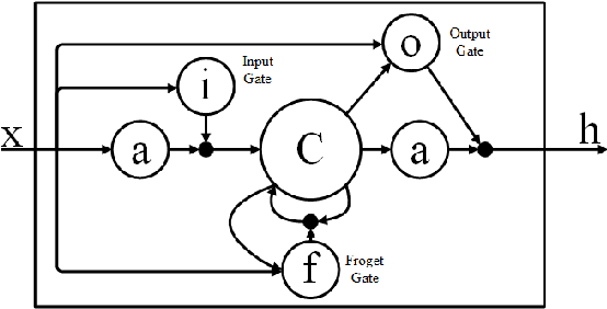
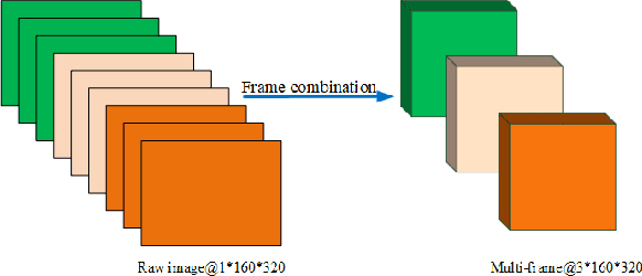
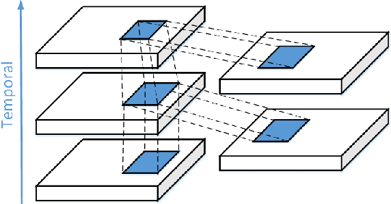
Abstract:Motion Planning, as a fundamental technology of automatic navigation for the autonomous vehicle, is still an open challenging issue in the real-life traffic situation and is mostly applied by the model-based approaches. However, due to the complexity of the traffic situations and the uncertainty of the edge cases, it is hard to devise a general motion planning system for the autonomous vehicle. In this paper, we proposed a motion planning model based on deep learning (named as spatiotemporal LSTM network), which is able to generate a real-time reflection based on spatiotemporal information extraction. To be specific, the model based on spatiotemporal LSTM network has three main structure. Firstly, the Convolutional Long-short Term Memory (Conv-LSTM) is used to extract hidden features through sequential image data. Then, the 3D Convolutional Neural Network(3D-CNN) is applied to extract the spatiotemporal information from the multi-frame feature information. Finally, the fully connected neural networks are used to construct a control model for autonomous vehicle steering angle. The experiments demonstrated that the proposed method can generate a robust and accurate visual motion planning results for the autonomous vehicle.
 Add to Chrome
 Add to Firefox
 Add to Edge