Xilin Xia
School of Architecture, Building and Civil Engineering, Loughborough University, Loughborough, United Kingdom
Accelerating Large Language Model Reasoning via Speculative Search
May 03, 2025Abstract:Tree-search-based reasoning methods have significantly enhanced the reasoning capability of large language models (LLMs) by facilitating the exploration of multiple intermediate reasoning steps, i.e., thoughts. However, these methods suffer from substantial inference latency, as they have to generate numerous reasoning thoughts, severely limiting LLM applicability. To address this challenge, we propose a novel Speculative Search (SpecSearch) framework that significantly accelerates LLM reasoning by optimizing thought generation. Specifically, SpecSearch utilizes a small model to strategically collaborate with a large model at both thought and token levels, efficiently generating high-quality reasoning thoughts. The major pillar of SpecSearch is a novel quality-preserving rejection mechanism, which effectively filters out thoughts whose quality falls below that of the large model's outputs. Moreover, we show that SpecSearch preserves comparable reasoning quality to the large model. Experiments on both the Qwen and Llama models demonstrate that SpecSearch significantly outperforms state-of-the-art approaches, achieving up to 2.12$\times$ speedup with comparable reasoning quality.
A deep convolutional neural network for rapid fluvial flood inundation modelling
Jun 20, 2020


Abstract:The two-dimensional (2D) hydrodynamic models are often infeasible for real-time operations. In this paper, a deep convolutional neural network (CNN)-based method is presented for rapid fluvial flood modelling. The CNN model is trained using outputs from a two-dimensional hydraulic model (i.e. LISFLOOD-FP) to predict water depths. The pre-trained model is then applied to simulate the flooding event that occurred in Carlisle, UK, in January 2005. The predictions are compared against the outputs produced by the calibrated LISFLOOD-FP. The performance of the CNN is also compared with a support vector regression (SVR)-based method. The results show that the CNN model outperforms SVR by a large margin. The model is highly accurate in capturing flooded cells as indicated by several quantitative assessment matrices, e.g., the estimated error for the peak flood depth is 0-0.2 meters for 97% cells of the domain when 99% confidence level is drawn. The proposed method offers great potential for real-time applications considering its simplicity, superior performance and computational efficiency.
A Multi-Scale Mapping Approach Based on a Deep Learning CNN Model for Reconstructing High-Resolution Urban DEMs
Jul 19, 2019


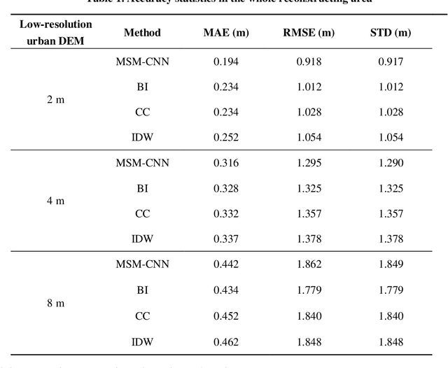
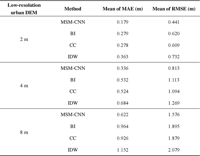
Abstract:The shortage of high-resolution urban digital elevation model (DEM) datasets has been a challenge for modelling urban flood and managing its risk. A solution is to develop effective approaches to reconstruct high-resolution DEMs from their low-resolution equivalents that are more widely available. However, the current high-resolution DEM reconstruction approaches mainly focus on natural topography. Few attempts have been made for urban topography which is typically an integration of complex man-made and natural features. This study proposes a novel multi-scale mapping approach based on convolutional neural network (CNN) to deal with the complex characteristics of urban topography and reconstruct high-resolution urban DEMs. The proposed multi-scale CNN model is firstly trained using urban DEMs that contain topographic features at different resolutions, and then used to reconstruct the urban DEM at a specified (high) resolution from a low-resolution equivalent. A two-level accuracy assessment approach is also designed to evaluate the performance of the proposed urban DEM reconstruction method, in terms of numerical accuracy and morphological accuracy. The proposed DEM reconstruction approach is applied to a 121 km2 urbanized area in London, UK. Compared with other commonly used methods, the current CNN based approach produces superior results, providing a cost-effective innovative method to acquire high-resolution DEMs in other data-scarce environments.
 Add to Chrome
 Add to Firefox
 Add to Edge