A Multi-Scale Mapping Approach Based on a Deep Learning CNN Model for Reconstructing High-Resolution Urban DEMs
Paper and Code
Jul 19, 2019


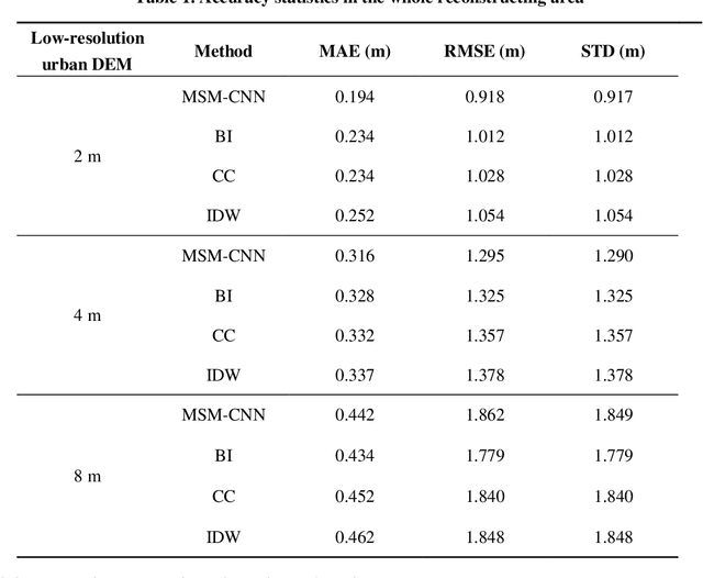
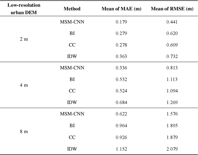
The shortage of high-resolution urban digital elevation model (DEM) datasets has been a challenge for modelling urban flood and managing its risk. A solution is to develop effective approaches to reconstruct high-resolution DEMs from their low-resolution equivalents that are more widely available. However, the current high-resolution DEM reconstruction approaches mainly focus on natural topography. Few attempts have been made for urban topography which is typically an integration of complex man-made and natural features. This study proposes a novel multi-scale mapping approach based on convolutional neural network (CNN) to deal with the complex characteristics of urban topography and reconstruct high-resolution urban DEMs. The proposed multi-scale CNN model is firstly trained using urban DEMs that contain topographic features at different resolutions, and then used to reconstruct the urban DEM at a specified (high) resolution from a low-resolution equivalent. A two-level accuracy assessment approach is also designed to evaluate the performance of the proposed urban DEM reconstruction method, in terms of numerical accuracy and morphological accuracy. The proposed DEM reconstruction approach is applied to a 121 km2 urbanized area in London, UK. Compared with other commonly used methods, the current CNN based approach produces superior results, providing a cost-effective innovative method to acquire high-resolution DEMs in other data-scarce environments.
 Add to Chrome
 Add to Firefox
 Add to Edge