William Qi
Argoverse 2: Next Generation Datasets for Self-Driving Perception and Forecasting
Jan 02, 2023


Abstract:We introduce Argoverse 2 (AV2) - a collection of three datasets for perception and forecasting research in the self-driving domain. The annotated Sensor Dataset contains 1,000 sequences of multimodal data, encompassing high-resolution imagery from seven ring cameras, and two stereo cameras in addition to lidar point clouds, and 6-DOF map-aligned pose. Sequences contain 3D cuboid annotations for 26 object categories, all of which are sufficiently-sampled to support training and evaluation of 3D perception models. The Lidar Dataset contains 20,000 sequences of unlabeled lidar point clouds and map-aligned pose. This dataset is the largest ever collection of lidar sensor data and supports self-supervised learning and the emerging task of point cloud forecasting. Finally, the Motion Forecasting Dataset contains 250,000 scenarios mined for interesting and challenging interactions between the autonomous vehicle and other actors in each local scene. Models are tasked with the prediction of future motion for "scored actors" in each scenario and are provided with track histories that capture object location, heading, velocity, and category. In all three datasets, each scenario contains its own HD Map with 3D lane and crosswalk geometry - sourced from data captured in six distinct cities. We believe these datasets will support new and existing machine learning research problems in ways that existing datasets do not. All datasets are released under the CC BY-NC-SA 4.0 license.
What-If Motion Prediction for Autonomous Driving
Aug 24, 2020


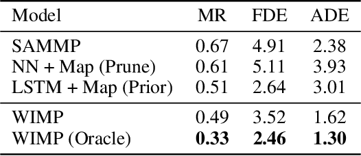
Abstract:Forecasting the long-term future motion of road actors is a core challenge to the deployment of safe autonomous vehicles (AVs). Viable solutions must account for both the static geometric context, such as road lanes, and dynamic social interactions arising from multiple actors. While recent deep architectures have achieved state-of-the-art performance on distance-based forecasting metrics, these approaches produce forecasts that are predicted without regard to the AV's intended motion plan. In contrast, we propose a recurrent graph-based attentional approach with interpretable geometric (actor-lane) and social (actor-actor) relationships that supports the injection of counterfactual geometric goals and social contexts. Our model can produce diverse predictions conditioned on hypothetical or "what-if" road lanes and multi-actor interactions. We show that such an approach could be used in the planning loop to reason about unobserved causes or unlikely futures that are directly relevant to the AV's intended route.
Learning to Move with Affordance Maps
Feb 14, 2020


Abstract:The ability to autonomously explore and navigate a physical space is a fundamental requirement for virtually any mobile autonomous agent, from household robotic vacuums to autonomous vehicles. Traditional SLAM-based approaches for exploration and navigation largely focus on leveraging scene geometry, but fail to model dynamic objects (such as other agents) or semantic constraints (such as wet floors or doorways). Learning-based RL agents are an attractive alternative because they can incorporate both semantic and geometric information, but are notoriously sample inefficient, difficult to generalize to novel settings, and are difficult to interpret. In this paper, we combine the best of both worlds with a modular approach that learns a spatial representation of a scene that is trained to be effective when coupled with traditional geometric planners. Specifically, we design an agent that learns to predict a spatial affordance map that elucidates what parts of a scene are navigable through active self-supervised experience gathering. In contrast to most simulation environments that assume a static world, we evaluate our approach in the VizDoom simulator, using large-scale randomly-generated maps containing a variety of dynamic actors and hazards. We show that learned affordance maps can be used to augment traditional approaches for both exploration and navigation, providing significant improvements in performance.
 Add to Chrome
 Add to Firefox
 Add to Edge