 Add to Chrome
 Add to Firefox
 Add to Edge
Mobility-Embedded POIs: Learning What A Place Is and How It Is Used from Human Movement
Jan 29, 2026Recent progress in geospatial foundation models highlights the importance of learning general-purpose representations for real-world locations, particularly points-of-interest (POIs) where human activity concentrates. Existing approaches, however, focus primarily on place identity derived from static textual metadata, or learn representations tied to trajectory context, which capture movement regularities rather than how places are actually used (i.e., POI's function). We argue that POI function is a missing but essential signal for general POI representations. We introduce Mobility-Embedded POIs (ME-POIs), a framework that augments POI embeddings derived, from language models with large-scale human mobility data to learn POI-centric, context-independent representations grounded in real-world usage. ME-POIs encodes individual visits as temporally contextualized embeddings and aligns them with learnable POI representations via contrastive learning to capture usage patterns across users and time. To address long-tail sparsity, we propose a novel mechanism that propagates temporal visit patterns from nearby, frequently visited POIs across multiple spatial scales. We evaluate ME-POIs on five newly proposed map enrichment tasks, testing its ability to capture both the identity and function of POIs. Across all tasks, augmenting text-based embeddings with ME-POIs consistently outperforms both text-only and mobility-only baselines. Notably, ME-POIs trained on mobility data alone can surpass text-only models on certain tasks, highlighting that POI function is a critical component of accurate and generalizable POI representations.
WaveGNN: Modeling Irregular Multivariate Time Series for Accurate Predictions
Dec 14, 2024


Accurately modeling and analyzing time series data is crucial for downstream applications across various fields, including healthcare, finance, astronomy, and epidemiology. However, real-world time series often exhibit irregularities such as misaligned timestamps, missing entries, and variable sampling rates, complicating their analysis. Existing approaches often rely on imputation, which can introduce biases. A few approaches that directly model irregularity tend to focus exclusively on either capturing intra-series patterns or inter-series relationships, missing the benefits of integrating both. To this end, we present WaveGNN, a novel framework designed to directly (i.e., no imputation) embed irregularly sampled multivariate time series data for accurate predictions. WaveGNN utilizes a Transformer-based encoder to capture intra-series patterns by directly encoding the temporal dynamics of each time series. To capture inter-series relationships, WaveGNN uses a dynamic graph neural network model, where each node represents a sensor, and the edges capture the long- and short-term relationships between them. Our experimental results on real-world healthcare datasets demonstrate that WaveGNN consistently outperforms existing state-of-the-art methods, with an average relative improvement of 14.7% in F1-score when compared to the second-best baseline in cases with extreme sparsity. Our ablation studies reveal that both intra-series and inter-series modeling significantly contribute to this notable improvement.
Poly2Vec: Polymorphic Encoding of Geospatial Objects for Spatial Reasoning with Deep Neural Networks
Aug 27, 2024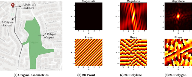
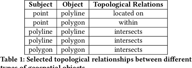
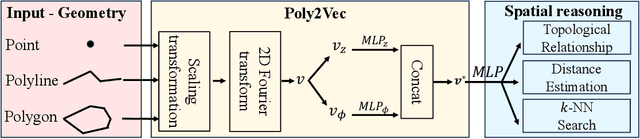
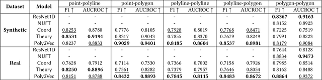
Encoding geospatial data is crucial for enabling machine learning (ML) models to perform tasks that require spatial reasoning, such as identifying the topological relationships between two different geospatial objects. However, existing encoding methods are limited as they are typically customized to handle only specific types of spatial data, which impedes their applicability across different downstream tasks where multiple data types coexist. To address this, we introduce Poly2Vec, an encoding framework that unifies the modeling of different geospatial objects, including 2D points, polylines, and polygons, irrespective of the downstream task. We leverage the power of the 2D Fourier transform to encode useful spatial properties, such as shape and location, from geospatial objects into fixed-length vectors. These vectors are then inputted into neural network models for spatial reasoning tasks.This unified approach eliminates the need to develop and train separate models for each distinct spatial type. We evaluate Poly2Vec on both synthetic and real datasets of mixed geometry types and verify its consistent performance across several downstream spatial reasoning tasks.
Learning Dynamic Graphs from All Contextual Information for Accurate Point-of-Interest Visit Forecasting
Jun 28, 2023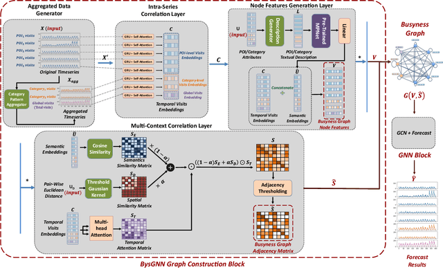
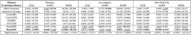
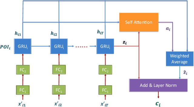
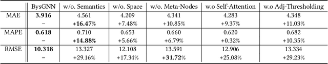
Forecasting the number of visits to Points-of-Interest (POI) in an urban area is critical for planning and decision-making for various application domains, from urban planning and transportation management to public health and social studies. Although this forecasting problem can be formulated as a multivariate time-series forecasting task, the current approaches cannot fully exploit the ever-changing multi-context correlations among POIs. Therefore, we propose Busyness Graph Neural Network (BysGNN), a temporal graph neural network designed to learn and uncover the underlying multi-context correlations between POIs for accurate visit forecasting. Unlike other approaches where only time-series data is used to learn a dynamic graph, BysGNN utilizes all contextual information and time-series data to learn an accurate dynamic graph representation. By incorporating all contextual, temporal, and spatial signals, we observe a significant improvement in our forecasting accuracy over state-of-the-art forecasting models in our experiments with real-world datasets across the United States.