Manuela Girotto
Responsible AI for Earth Observation
May 31, 2024Abstract:The convergence of artificial intelligence (AI) and Earth observation (EO) technologies has brought geoscience and remote sensing into an era of unparalleled capabilities. AI's transformative impact on data analysis, particularly derived from EO platforms, holds great promise in addressing global challenges such as environmental monitoring, disaster response and climate change analysis. However, the rapid integration of AI necessitates a careful examination of the responsible dimensions inherent in its application within these domains. In this paper, we represent a pioneering effort to systematically define the intersection of AI and EO, with a central focus on responsible AI practices. Specifically, we identify several critical components guiding this exploration from both academia and industry perspectives within the EO field: AI and EO for social good, mitigating unfair biases, AI security in EO, geo-privacy and privacy-preserving measures, as well as maintaining scientific excellence, open data, and guiding AI usage based on ethical principles. Furthermore, the paper explores potential opportunities and emerging trends, providing valuable insights for future research endeavors.
Snowpack Estimation in Key Mountainous Water Basins from Openly-Available, Multimodal Data Sources
Aug 08, 2022


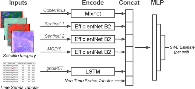
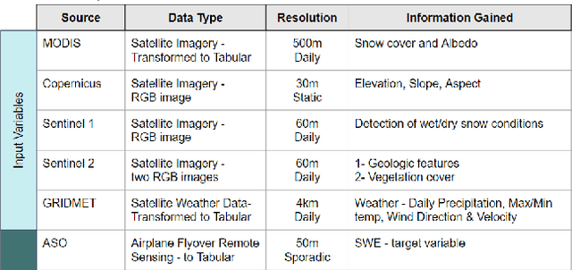
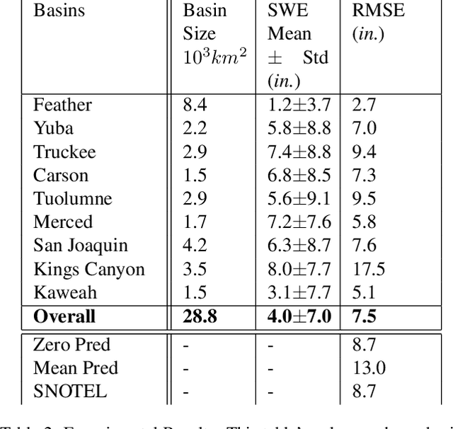
Abstract:Accurately estimating the snowpack in key mountainous basins is critical for water resource managers to make decisions that impact local and global economies, wildlife, and public policy. Currently, this estimation requires multiple LiDAR-equipped plane flights or in situ measurements, both of which are expensive, sparse, and biased towards accessible regions. In this paper, we demonstrate that fusing spatial and temporal information from multiple, openly-available satellite and weather data sources enables estimation of snowpack in key mountainous regions. Our multisource model outperforms single-source estimation by 5.0 inches RMSE, as well as outperforms sparse in situ measurements by 1.2 inches RMSE.
 Add to Chrome
 Add to Firefox
 Add to Edge