Alberto Todeschini
Upscaling Global Hourly GPP with Temporal Fusion Transformer (TFT)
Jun 23, 2023Abstract:Reliable estimates of Gross Primary Productivity (GPP), crucial for evaluating climate change initiatives, are currently only available from sparsely distributed eddy covariance tower sites. This limitation hampers access to reliable GPP quantification at regional to global scales. Prior machine learning studies on upscaling \textit{in situ} GPP to global wall-to-wall maps at sub-daily time steps faced limitations such as lack of input features at higher temporal resolutions and significant missing values. This research explored a novel upscaling solution using Temporal Fusion Transformer (TFT) without relying on past GPP time series. Model development was supplemented by Random Forest Regressor (RFR) and XGBoost, followed by the hybrid model of TFT and tree algorithms. The best preforming model yielded to model performance of 0.704 NSE and 3.54 RMSE. Another contribution of the study was the breakdown analysis of encoder feature importance based on time and flux tower sites. Such analysis enhanced the interpretability of the multi-head attention layer as well as the visual understanding of temporal dynamics of influential features.
Snowpack Estimation in Key Mountainous Water Basins from Openly-Available, Multimodal Data Sources
Aug 08, 2022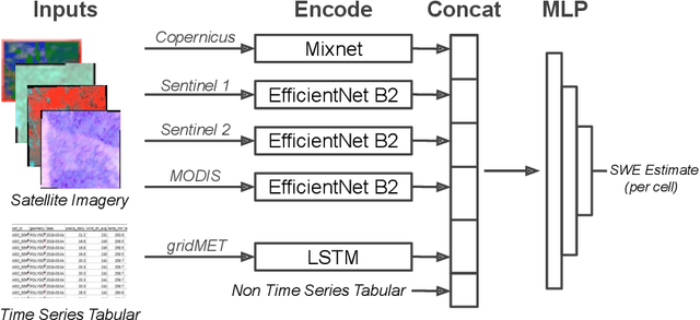
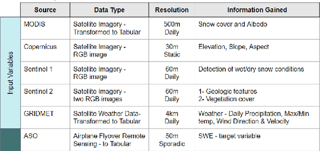
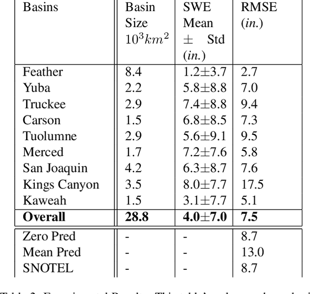
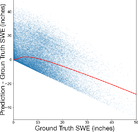
Abstract:Accurately estimating the snowpack in key mountainous basins is critical for water resource managers to make decisions that impact local and global economies, wildlife, and public policy. Currently, this estimation requires multiple LiDAR-equipped plane flights or in situ measurements, both of which are expensive, sparse, and biased towards accessible regions. In this paper, we demonstrate that fusing spatial and temporal information from multiple, openly-available satellite and weather data sources enables estimation of snowpack in key mountainous regions. Our multisource model outperforms single-source estimation by 5.0 inches RMSE, as well as outperforms sparse in situ measurements by 1.2 inches RMSE.
Deep Learning-Based Acoustic Mosquito Detection in Noisy Conditions Using Trainable Kernels and Augmentations
Jul 28, 2022


Abstract:In this paper, we demonstrate a unique recipe to enhance the effectiveness of audio machine learning approaches by fusing pre-processing techniques into a deep learning model. Our solution accelerates training and inference performance by optimizing hyper-parameters through training instead of costly random searches to build a reliable mosquito detector from audio signals. The experiments and the results presented here are part of the MOS C submission of the ACM 2022 challenge. Our results outperform the published baseline by 212% on the unpublished test set. We believe that this is one of the best real-world examples of building a robust bio-acoustic system that provides reliable mosquito detection in noisy conditions.
SunCast: Solar Irradiance Nowcasting from Geosynchronous Satellite Data
Jan 17, 2022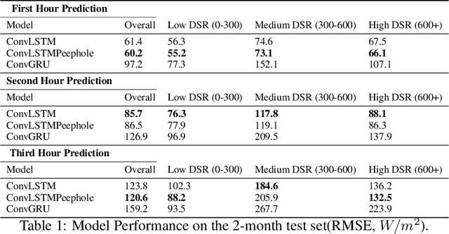
Abstract:When cloud layers cover photovoltaic (PV) panels, the amount of power the panels produce fluctuates rapidly. Therefore, to maintain enough energy on a power grid to match demand, utilities companies rely on reserve power sources that typically come from fossil fuels and therefore pollute the environment. Accurate short-term PV power prediction enables operators to maximize the amount of power obtained from PV panels and safely reduce the reserve energy needed from fossil fuel sources. While several studies have developed machine learning models to predict solar irradiance at specific PV generation facilities, little work has been done to model short-term solar irradiance on a global scale. Furthermore, models that have been developed are proprietary and have architectures that are not publicly available or rely on computationally demanding Numerical Weather Prediction (NWP) models. Here, we propose a Convolutional Long Short-Term Memory Network model that treats solar nowcasting as a next frame prediction problem, is more efficient than NWP models and has a straightforward, reproducible architecture. Our models can predict solar irradiance for entire North America for up to 3 hours in under 60 seconds on a single machine without a GPU and has a RMSE of 120 W/m2 when evaluated on 2 months of data.
HyperionSolarNet: Solar Panel Detection from Aerial Images
Jan 06, 2022


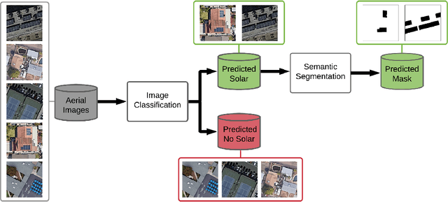
Abstract:With the effects of global climate change impacting the world, collective efforts are needed to reduce greenhouse gas emissions. The energy sector is the single largest contributor to climate change and many efforts are focused on reducing dependence on carbon-emitting power plants and moving to renewable energy sources, such as solar power. A comprehensive database of the location of solar panels is important to assist analysts and policymakers in defining strategies for further expansion of solar energy. In this paper we focus on creating a world map of solar panels. We identify locations and total surface area of solar panels within a given geographic area. We use deep learning methods for automated detection of solar panel locations and their surface area using aerial imagery. The framework, which consists of a two-branch model using an image classifier in tandem with a semantic segmentation model, is trained on our created dataset of satellite images. Our work provides an efficient and scalable method for detecting solar panels, achieving an accuracy of 0.96 for classification and an IoU score of 0.82 for segmentation performance.
Self-supervised Contrastive Learning for Irrigation Detection in Satellite Imagery
Aug 12, 2021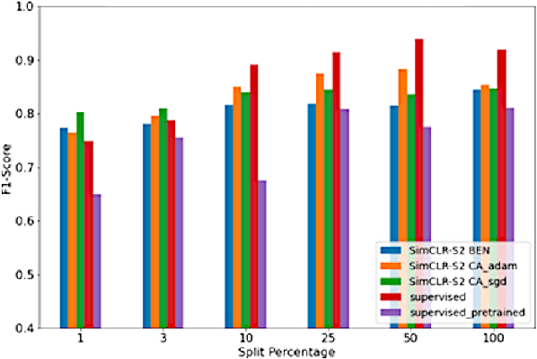
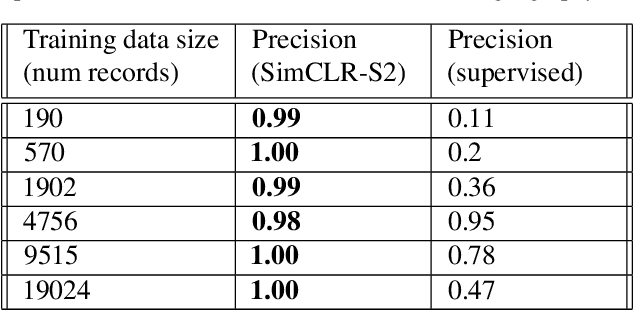
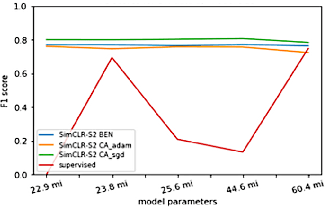
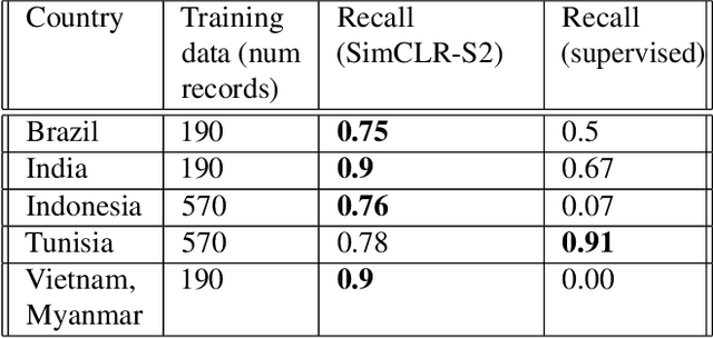
Abstract:Climate change has caused reductions in river runoffs and aquifer recharge resulting in an increasingly unsustainable crop water demand from reduced freshwater availability. Achieving food security while deploying water in a sustainable manner will continue to be a major challenge necessitating careful monitoring and tracking of agricultural water usage. Historically, monitoring water usage has been a slow and expensive manual process with many imperfections and abuses. Ma-chine learning and remote sensing developments have increased the ability to automatically monitor irrigation patterns, but existing techniques often require curated and labelled irrigation data, which are expensive and time consuming to obtain and may not exist for impactful areas such as developing countries. In this paper, we explore an end-to-end real world application of irrigation detection with uncurated and unlabeled satellite imagery. We apply state-of-the-art self-supervised deep learning techniques to optical remote sensing data, and find that we are able to detect irrigation with up to nine times better precision, 90% better recall and 40% more generalization ability than the traditional supervised learning methods.
High-resolution global irrigation prediction with Sentinel-2 30m data
Dec 09, 2020

Abstract:An accurate and precise understanding of global irrigation usage is crucial for a variety of climate science efforts. Irrigation is highly energy-intensive, and as population growth continues at its current pace, increases in crop need and water usage will have an impact on climate change. Precise irrigation data can help with monitoring water usage and optimizing agricultural yield, particularly in developing countries. Irrigation data, in tandem with precipitation data, can be used to predict water budgets as well as climate and weather modeling. With our research, we produce an irrigation prediction model that combines unsupervised clustering of Normalized Difference Vegetation Index (NDVI) temporal signatures with a precipitation heuristic to label the months that irrigation peaks for each cropland cluster in a given year. We have developed a novel irrigation model and Python package ("Irrigation30") to generate 30m resolution irrigation predictions of cropland worldwide. With a small crowdsourced test set of cropland coordinates and irrigation labels, using a fraction of the resources used by the state-of-the-art NASA-funded GFSAD30 project with irrigation data limited to India and Australia, our model was able to achieve consistency scores in excess of 97\% and an accuracy of 92\% in a small geo-diverse randomly sampled test set.
 Add to Chrome
 Add to Firefox
 Add to Edge