Kamal Das
Steve
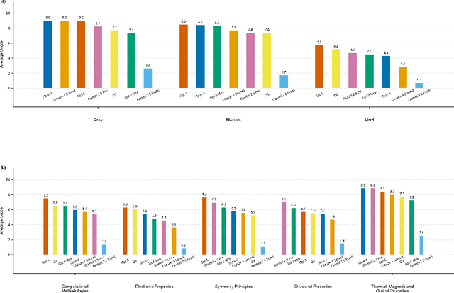
QMBench: A Research Level Benchmark for Quantum Materials Research
Dec 19, 2025

Abstract:We introduce QMBench, a comprehensive benchmark designed to evaluate the capability of large language model agents in quantum materials research. This specialized benchmark assesses the model's ability to apply condensed matter physics knowledge and computational techniques such as density functional theory to solve research problems in quantum materials science. QMBench encompasses different domains of the quantum material research, including structural properties, electronic properties, thermodynamic and other properties, symmetry principle and computational methodologies. By providing a standardized evaluation framework, QMBench aims to accelerate the development of an AI scientist capable of making creative contributions to quantum materials research. We expect QMBench to be developed and constantly improved by the research community.
Improving Power Plant CO2 Emission Estimation with Deep Learning and Satellite/Simulated Data
Feb 04, 2025


Abstract:CO2 emissions from power plants, as significant super emitters, contribute substantially to global warming. Accurate quantification of these emissions is crucial for effective climate mitigation strategies. While satellite-based plume inversion offers a promising approach, challenges arise from data limitations and the complexity of atmospheric conditions. This study addresses these challenges by (a) expanding the available dataset through the integration of NO2 data from Sentinel-5P, generating continuous XCO2 maps, and incorporating real satellite observations from OCO-2/3 for over 71 power plants in data-scarce regions; and (b) employing a customized U-Net model capable of handling diverse spatio-temporal resolutions for emission rate estimation. Our results demonstrate significant improvements in emission rate accuracy compared to previous methods. By leveraging this enhanced approach, we can enable near real-time, precise quantification of major CO2 emission sources, supporting environmental protection initiatives and informing regulatory frameworks.
Foundation Models for Generalist Geospatial Artificial Intelligence
Nov 08, 2023Abstract:Significant progress in the development of highly adaptable and reusable Artificial Intelligence (AI) models is expected to have a significant impact on Earth science and remote sensing. Foundation models are pre-trained on large unlabeled datasets through self-supervision, and then fine-tuned for various downstream tasks with small labeled datasets. This paper introduces a first-of-a-kind framework for the efficient pre-training and fine-tuning of foundational models on extensive geospatial data. We have utilized this framework to create Prithvi, a transformer-based geospatial foundational model pre-trained on more than 1TB of multispectral satellite imagery from the Harmonized Landsat-Sentinel 2 (HLS) dataset. Our study demonstrates the efficacy of our framework in successfully fine-tuning Prithvi to a range of Earth observation tasks that have not been tackled by previous work on foundation models involving multi-temporal cloud gap imputation, flood mapping, wildfire scar segmentation, and multi-temporal crop segmentation. Our experiments show that the pre-trained model accelerates the fine-tuning process compared to leveraging randomly initialized weights. In addition, pre-trained Prithvi compares well against the state-of-the-art, e.g., outperforming a conditional GAN model in multi-temporal cloud imputation by up to 5pp (or 5.7%) in the structural similarity index. Finally, due to the limited availability of labeled data in the field of Earth observation, we gradually reduce the quantity of available labeled data for refining the model to evaluate data efficiency and demonstrate that data can be decreased significantly without affecting the model's accuracy. The pre-trained 100 million parameter model and corresponding fine-tuning workflows have been released publicly as open source contributions to the global Earth sciences community through Hugging Face.
 Add to Chrome
 Add to Firefox
 Add to Edge