Jonathan Williams
Test-Time Alignment via Hypothesis Reweighting
Dec 11, 2024Abstract:Large pretrained models often struggle with underspecified tasks -- situations where the training data does not fully define the desired behavior. For example, chatbots must handle diverse and often conflicting user preferences, requiring adaptability to various user needs. We propose a novel framework to address the general challenge of aligning models to test-time user intent, which is rarely fully specified during training. Our approach involves training an efficient ensemble, i.e., a single neural network with multiple prediction heads, each representing a different function consistent with the training data. Our main contribution is HyRe, a simple adaptation technique that dynamically reweights ensemble members at test time using a small set of labeled examples from the target distribution, which can be labeled in advance or actively queried from a larger unlabeled pool. By leveraging recent advances in scalable ensemble training, our method scales to large pretrained models, with computational costs comparable to fine-tuning a single model. We empirically validate HyRe in several underspecified scenarios, including personalization tasks and settings with distribution shifts. Additionally, with just five preference pairs from each target distribution, the same ensemble adapted via HyRe outperforms the prior state-of-the-art 2B-parameter reward model accuracy across 18 evaluation distributions.
SLIC-UAV: A Method for monitoring recovery in tropical restoration projects through identification of signature species using UAVs
Jun 11, 2020


Abstract:Logged forests cover four million square kilometres of the tropics and restoring these forests is essential if we are to avoid the worst impacts of climate change, yet monitoring recovery is challenging. Tracking the abundance of visually identifiable, early-successional species enables successional status and thereby restoration progress to be evaluated. Here we present a new pipeline, SLIC-UAV, for processing Unmanned Aerial Vehicle (UAV) imagery to map early-successional species in tropical forests. The pipeline is novel because it comprises: (a) a time-efficient approach for labelling crowns from UAV imagery; (b) machine learning of species based on spectral and textural features within individual tree crowns, and (c) automatic segmentation of orthomosaiced UAV imagery into 'superpixels', using Simple Linear Iterative Clustering (SLIC). Creating superpixels reduces the dataset's dimensionality and focuses prediction onto clusters of pixels, greatly improving accuracy. To demonstrate SLIC-UAV, support vector machines and random forests were used to predict the species of hand-labelled crowns in a restoration concession in Indonesia. Random forests were most accurate at discriminating species for whole crowns, with accuracy ranging from 79.3% when mapping five common species, to 90.5% when mapping the three most visually-distinctive species. In contrast, support vector machines proved better for labelling automatically segmented superpixels, with accuracy ranging from 74.3% to 91.7% for the same species. Models were extended to map species across 100 hectares of forest. The study demonstrates the power of SLIC-UAV for mapping characteristic early-successional tree species as an indicator of successional stage within tropical forest restoration areas. Continued effort is needed to develop easy-to-implement and low-cost technology to improve the affordability of project management.
Three-dimensional Segmentation of Trees Through a Flexible Multi-Class Graph Cut Algorithm (MCGC)
Mar 20, 2019


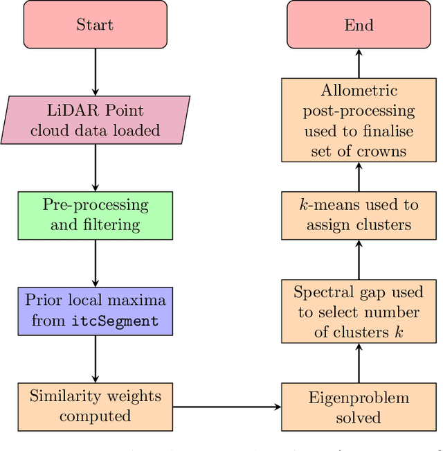
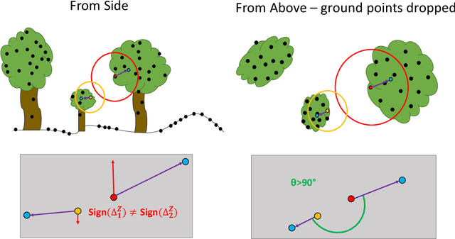
Abstract:Developing a robust algorithm for automatic individual tree crown (ITC) detection from laser scanning datasets is important for tracking the responses of trees to anthropogenic change. Such approaches allow the size, growth and mortality of individual trees to be measured, enabling forest carbon stocks and dynamics to be tracked and understood. Many algorithms exist for structurally simple forests including coniferous forests and plantations. Finding a robust solution for structurally complex, species-rich tropical forests remains a challenge; existing segmentation algorithms often perform less well than simple area-based approaches when estimating plot-level biomass. Here we describe a Multi-Class Graph Cut (MCGC) approach to tree crown delineation. This uses local three-dimensional geometry and density information, alongside knowledge of crown allometries, to segment individual tree crowns from LiDAR point clouds. Our approach robustly identifies trees in the top and intermediate layers of the canopy, but cannot recognise small trees. From these three-dimensional crowns, we are able to measure individual tree biomass. Comparing these estimates to those from permanent inventory plots, our algorithm is able to produce robust estimates of hectare-scale carbon density, demonstrating the power of ITC approaches in monitoring forests. The flexibility of our method to add additional dimensions of information, such as spectral reflectance, make this approach an obvious avenue for future development and extension to other sources of three-dimensional data, such as structure from motion datasets.
 Add to Chrome
 Add to Firefox
 Add to Edge