Dazhou Yu
Spatial-Agent: Agentic Geo-spatial Reasoning with Scientific Core Concepts
Jan 23, 2026Abstract:Geospatial reasoning is essential for real-world applications such as urban analytics, transportation planning, and disaster response. However, existing LLM-based agents often fail at genuine geospatial computation, relying instead on web search or pattern matching while hallucinating spatial relationships. We present Spatial-Agent, an AI agent grounded in foundational theories of spatial information science. Our approach formalizes geo-analytical question answering as a concept transformation problem, where natural-language questions are parsed into executable workflows represented as GeoFlow Graphs -- directed acyclic graphs with nodes corresponding to spatial concepts and edges representing transformations. Drawing on spatial information theory, Spatial-Agent extracts spatial concepts, assigns functional roles with principled ordering constraints, and composes transformation sequences through template-based generation. Extensive experiments on MapEval-API and MapQA benchmarks demonstrate that Spatial-Agent significantly outperforms existing baselines including ReAct and Reflexion, while producing interpretable and executable geospatial workflows.
PolyhedronNet: Representation Learning for Polyhedra with Surface-attributed Graph
Feb 03, 2025Abstract:Ubiquitous geometric objects can be precisely and efficiently represented as polyhedra. The transformation of a polyhedron into a vector, known as polyhedra representation learning, is crucial for manipulating these shapes with mathematical and statistical tools for tasks like classification, clustering, and generation. Recent years have witnessed significant strides in this domain, yet most efforts focus on the vertex sequence of a polyhedron, neglecting the complex surface modeling crucial in real-world polyhedral objects. This study proposes \textbf{PolyhedronNet}, a general framework tailored for learning representations of 3D polyhedral objects. We propose the concept of the surface-attributed graph to seamlessly model the vertices, edges, faces, and their geometric interrelationships within a polyhedron. To effectively learn the representation of the entire surface-attributed graph, we first propose to break it down into local rigid representations to effectively learn each local region's relative positions against the remaining regions without geometric information loss. Subsequently, we propose PolyhedronGNN to hierarchically aggregate the local rigid representation via intra-face and inter-face geometric message passing modules, to obtain a global representation that minimizes information loss while maintaining rotation and translation invariance. Our experimental evaluations on four distinct datasets, encompassing both classification and retrieval tasks, substantiate PolyhedronNet's efficacy in capturing comprehensive and informative representations of 3D polyhedral objects. Code and data are available at {https://github.com/dyu62/3D_polyhedron}.
PolygonGNN: Representation Learning for Polygonal Geometries with Heterogeneous Visibility Graph
Jun 30, 2024


Abstract:Polygon representation learning is essential for diverse applications, encompassing tasks such as shape coding, building pattern classification, and geographic question answering. While recent years have seen considerable advancements in this field, much of the focus has been on single polygons, overlooking the intricate inner- and inter-polygonal relationships inherent in multipolygons. To address this gap, our study introduces a comprehensive framework specifically designed for learning representations of polygonal geometries, particularly multipolygons. Central to our approach is the incorporation of a heterogeneous visibility graph, which seamlessly integrates both inner- and inter-polygonal relationships. To enhance computational efficiency and minimize graph redundancy, we implement a heterogeneous spanning tree sampling method. Additionally, we devise a rotation-translation invariant geometric representation, ensuring broader applicability across diverse scenarios. Finally, we introduce Multipolygon-GNN, a novel model tailored to leverage the spatial and semantic heterogeneity inherent in the visibility graph. Experiments on five real-world and synthetic datasets demonstrate its ability to capture informative representations for polygonal geometries.
Self-consistent Deep Geometric Learning for Heterogeneous Multi-source Spatial Point Data Prediction
Jun 30, 2024


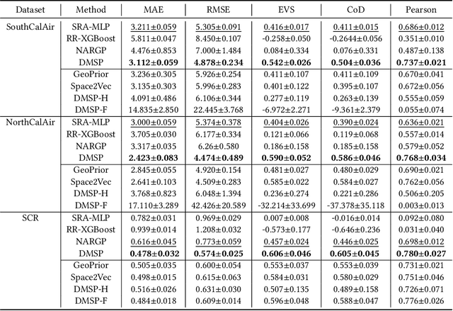
Abstract:Multi-source spatial point data prediction is crucial in fields like environmental monitoring and natural resource management, where integrating data from various sensors is the key to achieving a holistic environmental understanding. Existing models in this area often fall short due to their domain-specific nature and lack a strategy for integrating information from various sources in the absence of ground truth labels. Key challenges include evaluating the quality of different data sources and modeling spatial relationships among them effectively. Addressing these issues, we introduce an innovative multi-source spatial point data prediction framework that adeptly aligns information from varied sources without relying on ground truth labels. A unique aspect of our method is the 'fidelity score,' a quantitative measure for evaluating the reliability of each data source. Furthermore, we develop a geo-location-aware graph neural network tailored to accurately depict spatial relationships between data points. Our framework has been rigorously tested on two real-world datasets and one synthetic dataset. The results consistently demonstrate its superior performance over existing state-of-the-art methods.
Graph Neural Network for spatiotemporal data: methods and applications
May 30, 2023Abstract:In the era of big data, there has been a surge in the availability of data containing rich spatial and temporal information, offering valuable insights into dynamic systems and processes for applications such as weather forecasting, natural disaster management, intelligent transport systems, and precision agriculture. Graph neural networks (GNNs) have emerged as a powerful tool for modeling and understanding data with dependencies to each other such as spatial and temporal dependencies. There is a large amount of existing work that focuses on addressing the complex spatial and temporal dependencies in spatiotemporal data using GNNs. However, the strong interdisciplinary nature of spatiotemporal data has created numerous GNNs variants specifically designed for distinct application domains. Although the techniques are generally applicable across various domains, cross-referencing these methods remains essential yet challenging due to the absence of a comprehensive literature review on GNNs for spatiotemporal data. This article aims to provide a systematic and comprehensive overview of the technologies and applications of GNNs in the spatiotemporal domain. First, the ways of constructing graphs from spatiotemporal data are summarized to help domain experts understand how to generate graphs from various types of spatiotemporal data. Then, a systematic categorization and summary of existing spatiotemporal GNNs are presented to enable domain experts to identify suitable techniques and to support model developers in advancing their research. Moreover, a comprehensive overview of significant applications in the spatiotemporal domain is offered to introduce a broader range of applications to model developers and domain experts, assisting them in exploring potential research topics and enhancing the impact of their work. Finally, open challenges and future directions are discussed.
Going Beyond XAI: A Systematic Survey for Explanation-Guided Learning
Dec 07, 2022


Abstract:As the societal impact of Deep Neural Networks (DNNs) grows, the goals for advancing DNNs become more complex and diverse, ranging from improving a conventional model accuracy metric to infusing advanced human virtues such as fairness, accountability, transparency (FaccT), and unbiasedness. Recently, techniques in Explainable Artificial Intelligence (XAI) are attracting considerable attention, and have tremendously helped Machine Learning (ML) engineers in understanding AI models. However, at the same time, we started to witness the emerging need beyond XAI among AI communities; based on the insights learned from XAI, how can we better empower ML engineers in steering their DNNs so that the model's reasonableness and performance can be improved as intended? This article provides a timely and extensive literature overview of the field Explanation-Guided Learning (EGL), a domain of techniques that steer the DNNs' reasoning process by adding regularization, supervision, or intervention on model explanations. In doing so, we first provide a formal definition of EGL and its general learning paradigm. Secondly, an overview of the key factors for EGL evaluation, as well as summarization and categorization of existing evaluation procedures and metrics for EGL are provided. Finally, the current and potential future application areas and directions of EGL are discussed, and an extensive experimental study is presented aiming at providing comprehensive comparative studies among existing EGL models in various popular application domains, such as Computer Vision (CV) and Natural Language Processing (NLP) domains.
Deep Spatial Domain Generalization
Oct 03, 2022

Abstract:Spatial autocorrelation and spatial heterogeneity widely exist in spatial data, which make the traditional machine learning model perform badly. Spatial domain generalization is a spatial extension of domain generalization, which can generalize to unseen spatial domains in continuous 2D space. Specifically, it learns a model under varying data distributions that generalizes to unseen domains. Although tremendous success has been achieved in domain generalization, there exist very few works on spatial domain generalization. The advancement of this area is challenged by: 1) Difficulty in characterizing spatial heterogeneity, and 2) Difficulty in obtaining predictive models for unseen locations without training data. To address these challenges, this paper proposes a generic framework for spatial domain generalization. Specifically, We develop the spatial interpolation graph neural network that handles spatial data as a graph and learns the spatial embedding on each node and their relationships. The spatial interpolation graph neural network infers the spatial embedding of an unseen location during the test phase. Then the spatial embedding of the target location is used to decode the parameters of the downstream-task model directly on the target location. Finally, extensive experiments on thirteen real-world datasets demonstrate the proposed method's strength.
 Add to Chrome
 Add to Firefox
 Add to Edge