Akram Zaytar
TEMPO: Global Temporal Building Density and Height Estimation from Satellite Imagery
Nov 15, 2025Abstract:We present TEMPO, a global, temporally resolved dataset of building density and height derived from high-resolution satellite imagery using deep learning models. We pair building footprint and height data from existing datasets with quarterly PlanetScope basemap satellite images to train a multi-task deep learning model that predicts building density and building height at a 37.6-meter per pixel resolution. We apply this model to global PlanetScope basemaps from Q1 2018 through Q2 2025 to create global, temporal maps of building density and height. We validate these maps by comparing against existing building footprint datasets. Our estimates achieve an F1 score between 85% and 88% on different hand-labeled subsets, and are temporally stable, with a 0.96 five-year trend-consistency score. TEMPO captures quarterly changes in built settlements at a fraction of the computational cost of comparable approaches, unlocking large-scale monitoring of development patterns and climate impacts essential for global resilience and adaptation efforts.
Optimizing Cloud-to-GPU Throughput for Deep Learning With Earth Observation Data
Jun 06, 2025Abstract:Training deep learning models on petabyte-scale Earth observation (EO) data requires separating compute resources from data storage. However, standard PyTorch data loaders cannot keep modern GPUs utilized when streaming GeoTIFF files directly from cloud storage. In this work, we benchmark GeoTIFF loading throughput from both cloud object storage and local SSD, systematically testing different loader configurations and data parameters. We focus on tile-aligned reads and worker thread pools, using Bayesian optimization to find optimal settings for each storage type. Our optimized configurations increase remote data loading throughput by 20x and local throughput by 4x compared to default settings. On three public EO benchmarks, models trained with optimized remote loading achieve the same accuracy as local training within identical time budgets. We improve validation IoU by 6-15% and maintain 85-95% GPU utilization versus 0-30% with standard configurations. Code is publicly available at https://github.com/microsoft/pytorch-cloud-geotiff-optimization
GeoVision Labeler: Zero-Shot Geospatial Classification with Vision and Language Models
May 30, 2025Abstract:Classifying geospatial imagery remains a major bottleneck for applications such as disaster response and land-use monitoring-particularly in regions where annotated data is scarce or unavailable. Existing tools (e.g., RS-CLIP) that claim zero-shot classification capabilities for satellite imagery nonetheless rely on task-specific pretraining and adaptation to reach competitive performance. We introduce GeoVision Labeler (GVL), a strictly zero-shot classification framework: a vision Large Language Model (vLLM) generates rich, human-readable image descriptions, which are then mapped to user-defined classes by a conventional Large Language Model (LLM). This modular, and interpretable pipeline enables flexible image classification for a large range of use cases. We evaluated GVL across three benchmarks-SpaceNet v7, UC Merced, and RESISC45. It achieves up to 93.2% zero-shot accuracy on the binary Buildings vs. No Buildings task on SpaceNet v7. For complex multi-class classification tasks (UC Merced, RESISC45), we implemented a recursive LLM-driven clustering to form meta-classes at successive depths, followed by hierarchical classification-first resolving coarse groups, then finer distinctions-to deliver competitive zero-shot performance. GVL is open-sourced at https://github.com/microsoft/geo-vision-labeler to catalyze adoption in real-world geospatial workflows.
Core-Set Selection for Data-efficient Land Cover Segmentation
May 02, 2025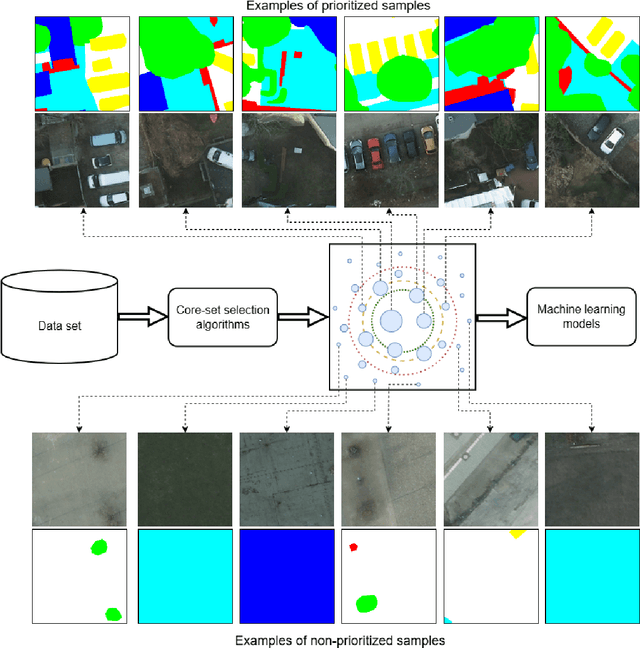
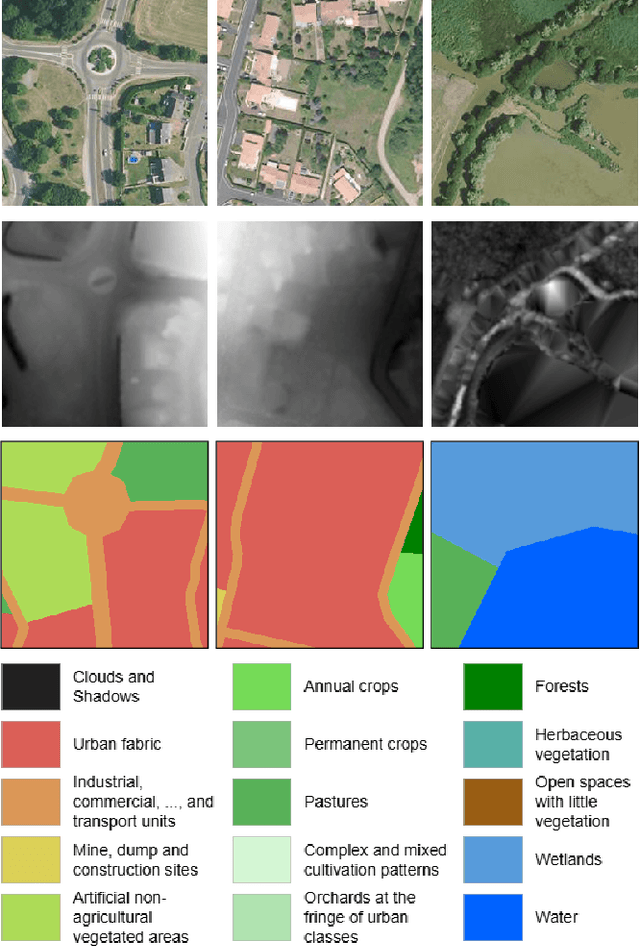
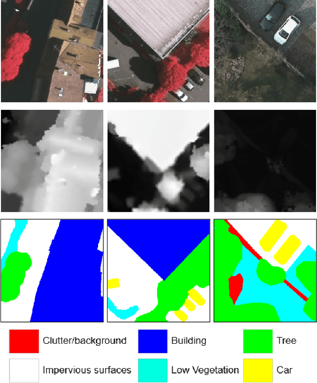

Abstract:The increasing accessibility of remotely sensed data and the potential of such data to inform large-scale decision-making has driven the development of deep learning models for many Earth Observation tasks. Traditionally, such models must be trained on large datasets. However, the common assumption that broadly larger datasets lead to better outcomes tends to overlook the complexities of the data distribution, the potential for introducing biases and noise, and the computational resources required for processing and storing vast datasets. Therefore, effective solutions should consider both the quantity and quality of data. In this paper, we propose six novel core-set selection methods for selecting important subsets of samples from remote sensing image segmentation datasets that rely on imagery only, labels only, and a combination of each. We benchmark these approaches against a random-selection baseline on three commonly used land cover classification datasets: DFC2022, Vaihingen, and Potsdam. In each of the datasets, we demonstrate that training on a subset of samples outperforms the random baseline, and some approaches outperform training on all available data. This result shows the importance and potential of data-centric learning for the remote sensing domain. The code is available at https://github.com/keillernogueira/data-centric-rs-classification/.
Sims: An Interactive Tool for Geospatial Matching and Clustering
Dec 13, 2024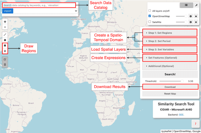
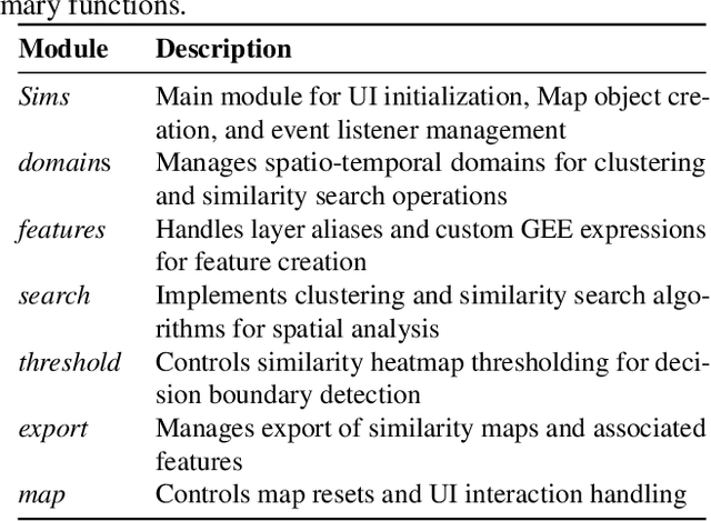

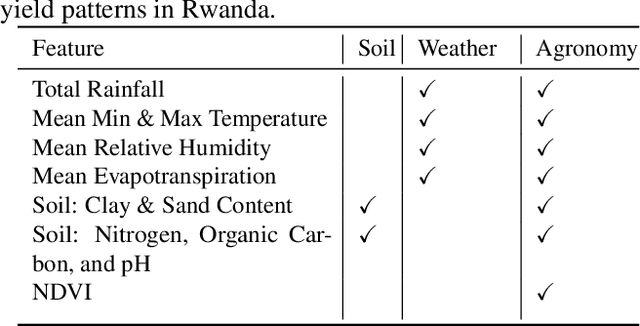
Abstract:Acquiring, processing, and visualizing geospatial data requires significant computing resources, especially for large spatio-temporal domains. This challenge hinders the rapid discovery of predictive features, which is essential for advancing geospatial modeling. To address this, we developed Similarity Search (Sims), a no-code web tool that allows users to visualize, compare, cluster, and perform similarity search over defined regions of interest using Google Earth Engine as a backend. Sims is designed to complement existing modeling tools by focusing on feature exploration rather than model creation. We demonstrate the utility of Sims through a case study analyzing simulated maize yield data in Rwanda, where we evaluate how different combinations of soil, weather, and agronomic features affect the clustering of yield response zones. Sims is open source and available at https://github.com/microsoft/Sims
Analyzing Decades-Long Environmental Changes in Namibia Using Archival Aerial Photography and Deep Learning
Apr 12, 2024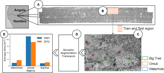


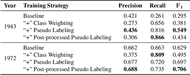
Abstract:This study explores object detection in historical aerial photographs of Namibia to identify long-term environmental changes. Specifically, we aim to identify key objects -- \textit{Waterholes}, \textit{Omuti homesteads}, and \textit{Big trees} -- around Oshikango in Namibia using sub-meter gray-scale aerial imagery from 1943 and 1972. In this work, we propose a workflow for analyzing historical aerial imagery using a deep semantic segmentation model on sparse hand-labels. To this end, we employ a number of strategies including class-weighting, pseudo-labeling and empirical p-value-based filtering to balance skewed and sparse representations of objects in the ground truth data. Results demonstrate the benefits of these different training strategies resulting in an average $F_1=0.661$ and $F_1=0.755$ over the three objects of interest for the 1943 and 1972 imagery, respectively. We also identified that the average size of Waterhole and Big trees increased while the average size of Omutis decreased between 1943 and 1972 reflecting some of the local effects of the massive post-Second World War economic, agricultural, demographic, and environmental changes. This work also highlights the untapped potential of historical aerial photographs in understanding long-term environmental changes beyond Namibia (and Africa). With the lack of adequate satellite technology in the past, archival aerial photography offers a great alternative to uncover decades-long environmental changes.
Bootstrapping Rare Object Detection in High-Resolution Satellite Imagery
Mar 05, 2024


Abstract:Rare object detection is a fundamental task in applied geospatial machine learning, however is often challenging due to large amounts of high-resolution satellite or aerial imagery and few or no labeled positive samples to start with. This paper addresses the problem of bootstrapping such a rare object detection task assuming there is no labeled data and no spatial prior over the area of interest. We propose novel offline and online cluster-based approaches for sampling patches that are significantly more efficient, in terms of exposing positive samples to a human annotator, than random sampling. We apply our methods for identifying bomas, or small enclosures for herd animals, in the Serengeti Mara region of Kenya and Tanzania. We demonstrate a significant enhancement in detection efficiency, achieving a positive sampling rate increase from 2% (random) to 30%. This advancement enables effective machine learning mapping even with minimal labeling budgets, exemplified by an F1 score on the boma detection task of 0.51 with a budget of 300 total patches.
Weak Labeling for Cropland Mapping in Africa
Jan 13, 2024

Abstract:Cropland mapping can play a vital role in addressing environmental, agricultural, and food security challenges. However, in the context of Africa, practical applications are often hindered by the limited availability of high-resolution cropland maps. Such maps typically require extensive human labeling, thereby creating a scalability bottleneck. To address this, we propose an approach that utilizes unsupervised object clustering to refine existing weak labels, such as those obtained from global cropland maps. The refined labels, in conjunction with sparse human annotations, serve as training data for a semantic segmentation network designed to identify cropland areas. We conduct experiments to demonstrate the benefits of the improved weak labels generated by our method. In a scenario where we train our model with only 33 human-annotated labels, the F_1 score for the cropland category increases from 0.53 to 0.84 when we add the mined negative labels.
 Add to Chrome
 Add to Firefox
 Add to Edge