Gilles Quentin Hacheme
GeoVision Labeler: Zero-Shot Geospatial Classification with Vision and Language Models
May 30, 2025Abstract:Classifying geospatial imagery remains a major bottleneck for applications such as disaster response and land-use monitoring-particularly in regions where annotated data is scarce or unavailable. Existing tools (e.g., RS-CLIP) that claim zero-shot classification capabilities for satellite imagery nonetheless rely on task-specific pretraining and adaptation to reach competitive performance. We introduce GeoVision Labeler (GVL), a strictly zero-shot classification framework: a vision Large Language Model (vLLM) generates rich, human-readable image descriptions, which are then mapped to user-defined classes by a conventional Large Language Model (LLM). This modular, and interpretable pipeline enables flexible image classification for a large range of use cases. We evaluated GVL across three benchmarks-SpaceNet v7, UC Merced, and RESISC45. It achieves up to 93.2% zero-shot accuracy on the binary Buildings vs. No Buildings task on SpaceNet v7. For complex multi-class classification tasks (UC Merced, RESISC45), we implemented a recursive LLM-driven clustering to form meta-classes at successive depths, followed by hierarchical classification-first resolving coarse groups, then finer distinctions-to deliver competitive zero-shot performance. GVL is open-sourced at https://github.com/microsoft/geo-vision-labeler to catalyze adoption in real-world geospatial workflows.
Local vs. Global: Local Land-Use and Land-Cover Models Deliver Higher Quality Maps
Dec 01, 2024


Abstract:Approximately 20% of Africa's population suffered from undernourishment, and 868 million people experienced moderate to severe food insecurity in 2022. Land-use and land-cover maps provide crucial insights for addressing food insecurity, e.g., by mapping croplands. The development of global land-cover maps has been facilitated by the increasing availability of earth observation data and advancements in geospatial machine learning. However, these global maps exhibit lower accuracy and inconsistencies in Africa, partly due to the lack of representative training data. To address this issue, we propose a data-centric framework with a teacher-student model setup, which uses diverse data sources of satellite images and label examples to produce local land-cover maps. Our method trains a high-resolution teacher model on images with a resolution of 0.331 m/pixel and a low-resolution student model on publicly available images with a resolution of 10 m/pixel. The student model also utilizes the teacher model's output as its weak label examples through knowledge distillation. We evaluated our framework using Murang'a County, Kenya, as a use case and achieved significant improvements, i.e., 0.14 in the F1 score and 0.21 in Intersection-over-Union, compared to the best global map. Our evaluation also revealed inconsistencies in existing global maps, with a maximum agreement rate of 0.30 among themselves. Insights obtained from our cross-collaborative work can provide valuable guidance to local and national policymakers in making informed decisions to improve resource utilization and food security.
Analyzing Decades-Long Environmental Changes in Namibia Using Archival Aerial Photography and Deep Learning
Apr 12, 2024


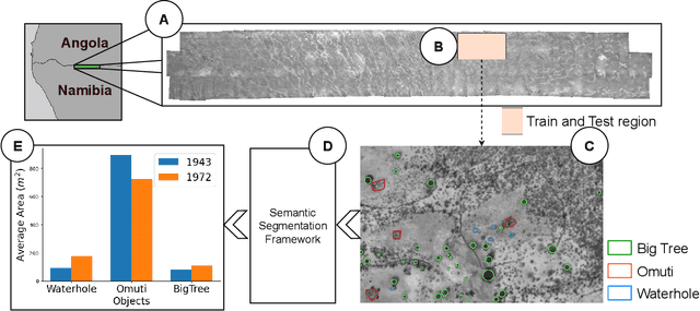
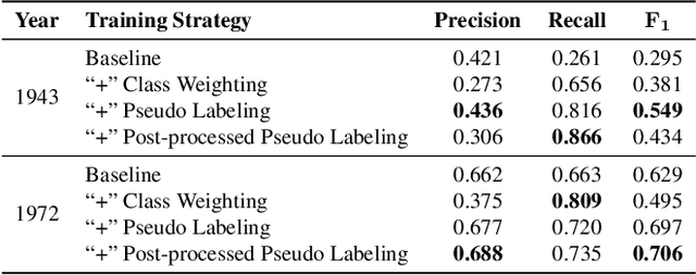
Abstract:This study explores object detection in historical aerial photographs of Namibia to identify long-term environmental changes. Specifically, we aim to identify key objects -- \textit{Waterholes}, \textit{Omuti homesteads}, and \textit{Big trees} -- around Oshikango in Namibia using sub-meter gray-scale aerial imagery from 1943 and 1972. In this work, we propose a workflow for analyzing historical aerial imagery using a deep semantic segmentation model on sparse hand-labels. To this end, we employ a number of strategies including class-weighting, pseudo-labeling and empirical p-value-based filtering to balance skewed and sparse representations of objects in the ground truth data. Results demonstrate the benefits of these different training strategies resulting in an average $F_1=0.661$ and $F_1=0.755$ over the three objects of interest for the 1943 and 1972 imagery, respectively. We also identified that the average size of Waterhole and Big trees increased while the average size of Omutis decreased between 1943 and 1972 reflecting some of the local effects of the massive post-Second World War economic, agricultural, demographic, and environmental changes. This work also highlights the untapped potential of historical aerial photographs in understanding long-term environmental changes beyond Namibia (and Africa). With the lack of adequate satellite technology in the past, archival aerial photography offers a great alternative to uncover decades-long environmental changes.
Weak Labeling for Cropland Mapping in Africa
Jan 13, 2024

Abstract:Cropland mapping can play a vital role in addressing environmental, agricultural, and food security challenges. However, in the context of Africa, practical applications are often hindered by the limited availability of high-resolution cropland maps. Such maps typically require extensive human labeling, thereby creating a scalability bottleneck. To address this, we propose an approach that utilizes unsupervised object clustering to refine existing weak labels, such as those obtained from global cropland maps. The refined labels, in conjunction with sparse human annotations, serve as training data for a semantic segmentation network designed to identify cropland areas. We conduct experiments to demonstrate the benefits of the improved weak labels generated by our method. In a scenario where we train our model with only 33 human-annotated labels, the F_1 score for the cropland category increases from 0.53 to 0.84 when we add the mined negative labels.
 Add to Chrome
 Add to Firefox
 Add to Edge