Upmanu Lall
Deep Learning and Foundation Models for Weather Prediction: A Survey
Jan 12, 2025Abstract:Physics-based numerical models have been the bedrock of atmospheric sciences for decades, offering robust solutions but often at the cost of significant computational resources. Deep learning (DL) models have emerged as powerful tools in meteorology, capable of analyzing complex weather and climate data by learning intricate dependencies and providing rapid predictions once trained. While these models demonstrate promising performance in weather prediction, often surpassing traditional physics-based methods, they still face critical challenges. This paper presents a comprehensive survey of recent deep learning and foundation models for weather prediction. We propose a taxonomy to classify existing models based on their training paradigms: deterministic predictive learning, probabilistic generative learning, and pre-training and fine-tuning. For each paradigm, we delve into the underlying model architectures, address major challenges, offer key insights, and propose targeted directions for future research. Furthermore, we explore real-world applications of these methods and provide a curated summary of open-source code repositories and widely used datasets, aiming to bridge research advancements with practical implementations while fostering open and trustworthy scientific practices in adopting cutting-edge artificial intelligence for weather prediction. The related sources are available at https://github.com/JimengShi/ DL-Foundation-Models-Weather.
Flood Event Extraction from News Media to Support Satellite-Based Flood Insurance
Dec 05, 2023Abstract:Floods cause large losses to property, life, and livelihoods across the world every year, hindering sustainable development. Safety nets to help absorb financial shocks in disasters, such as insurance, are often unavailable in regions of the world most vulnerable to floods, like Bangladesh. Index-based insurance has emerged as an affordable solution, which considers weather data or information from satellites to create a "flood index" that should correlate with the damage insured. However, existing flood event databases are often incomplete, and satellite sensors are not reliable under extreme weather conditions (e.g., because of clouds), which limits the spatial and temporal resolution of current approaches for index-based insurance. In this work, we explore a novel approach for supporting satellite-based flood index insurance by extracting high-resolution spatio-temporal information from news media. First, we publish a dataset consisting of 40,000 news articles covering flood events in Bangladesh by 10 prominent news sources, and inundated area estimates for each division in Bangladesh collected from a satellite radar sensor. Second, we show that keyword-based models are not adequate for this novel application, while context-based classifiers cover complex and implicit flood related patterns. Third, we show that time series extracted from news media have substantial correlation Spearman's rho$=0.70 with satellite estimates of inundated area. Our work demonstrates that news media is a promising source for improving the temporal resolution and expanding the spatial coverage of the available flood damage data.
Spatial-temporal wind field prediction by Artificial Neural Networks
Dec 13, 2017


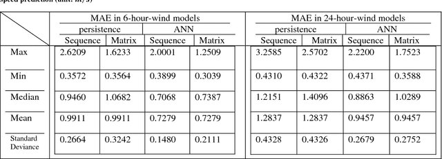
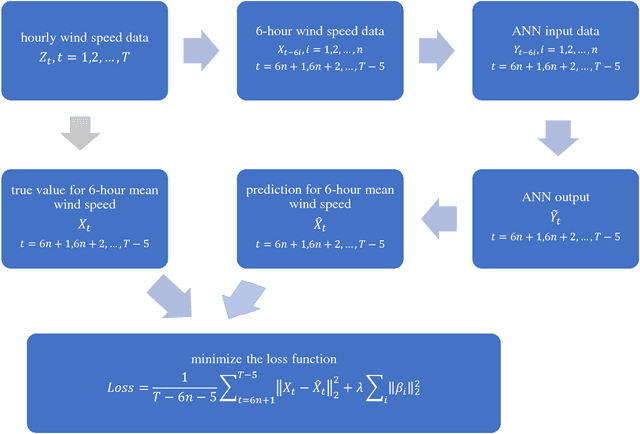
Abstract:The prediction of near surface wind speed is becoming increasingly vital for the operation of electrical energy grids as the capacity of installed wind power grows. The majority of predictive wind speed modeling has focused on point-based time-series forecasting. Effectively balancing demand and supply in the presence of distributed wind turbine electricity generation, however, requires the prediction of wind fields in space and time. Additionally, predictions of full wind fields are particularly useful for future power planning such as the optimization of electricity power supply systems. In this paper, we propose a composite artificial neural network (ANN) model to predict the 6-hour and 24-hour ahead average wind speed over a large area (~3.15*106 km2). The ANN model consists of a convolutional input layer, a Long Short-Term Memory (LSTM) hidden layer, and a transposed convolutional layer as the output layer. We compare the ANN model with two non-parametric models, a null persistence model and a mean value model, and find that the ANN model has substantially smaller error than each of these models. Additionally, the ANN model also generally performs better than integrated autoregressive moving average models, which are trained for optimal performance in specific locations.
 Add to Chrome
 Add to Firefox
 Add to Edge