Qinhua Jiang
MobiFuse: Learning Universal Human Mobility Patterns through Cross-domain Data Fusion
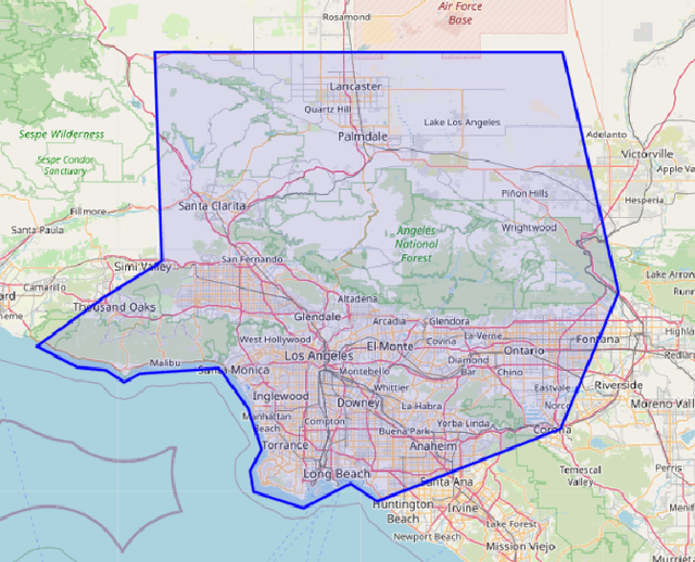
Mar 20, 2025Abstract:Human mobility modeling is critical for urban planning and transportation management, yet existing datasets often lack the resolution and semantic richness required for comprehensive analysis. To address this, we proposed a cross-domain data fusion framework that integrates multi-modal data of distinct nature and spatio-temporal resolution, including geographical, mobility, socio-demographic, and traffic information, to construct a privacy-preserving and semantically enriched human travel trajectory dataset. This framework is demonstrated through two case studies in Los Angeles (LA) and Egypt, where a domain adaptation algorithm ensures its transferability across diverse urban contexts. Quantitative evaluation shows that the generated synthetic dataset accurately reproduces mobility patterns observed in empirical data. Moreover, large-scale traffic simulations for LA County based on the generated synthetic demand align well with observed traffic. On California's I-405 corridor, the simulation yields a Mean Absolute Percentage Error of 5.85% for traffic volume and 4.36% for speed compared to Caltrans PeMS observations.
NUMOSIM: A Synthetic Mobility Dataset with Anomaly Detection Benchmarks
Sep 04, 2024


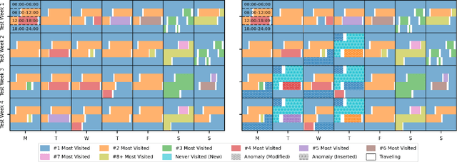
Abstract:Collecting real-world mobility data is challenging. It is often fraught with privacy concerns, logistical difficulties, and inherent biases. Moreover, accurately annotating anomalies in large-scale data is nearly impossible, as it demands meticulous effort to distinguish subtle and complex patterns. These challenges significantly impede progress in geospatial anomaly detection research by restricting access to reliable data and complicating the rigorous evaluation, comparison, and benchmarking of methodologies. To address these limitations, we introduce a synthetic mobility dataset, NUMOSIM, that provides a controlled, ethical, and diverse environment for benchmarking anomaly detection techniques. NUMOSIM simulates a wide array of realistic mobility scenarios, encompassing both typical and anomalous behaviours, generated through advanced deep learning models trained on real mobility data. This approach allows NUMOSIM to accurately replicate the complexities of real-world movement patterns while strategically injecting anomalies to challenge and evaluate detection algorithms based on how effectively they capture the interplay between demographic, geospatial, and temporal factors. Our goal is to advance geospatial mobility analysis by offering a realistic benchmark for improving anomaly detection and mobility modeling techniques. To support this, we provide open access to the NUMOSIM dataset, along with comprehensive documentation, evaluation metrics, and benchmark results.
Deploying scalable traffic prediction models for efficient management in real-world large transportation networks during hurricane evacuations
Jun 17, 2024


Abstract:Accurate traffic prediction is vital for effective traffic management during hurricane evacuation. This paper proposes a predictive modeling system that integrates Multilayer Perceptron (MLP) and Long-Short Term Memory (LSTM) models to capture both long-term congestion patterns and short-term speed patterns. Leveraging various input variables, including archived traffic data, spatial-temporal road network information, and hurricane forecast data, the framework is designed to address challenges posed by heterogeneous human behaviors, limited evacuation data, and hurricane event uncertainties. Deployed in a real-world traffic prediction system in Louisiana, the model achieved an 82% accuracy in predicting long-term congestion states over a 6-hour period during a 7-day hurricane-impacted duration. The short-term speed prediction model exhibited Mean Absolute Percentage Errors (MAPEs) ranging from 7% to 13% across evacuation horizons from 1 to 6 hours. Evaluation results underscore the model's potential to enhance traffic management during hurricane evacuations, and real-world deployment highlights its adaptability and scalability in diverse hurricane scenarios within extensive transportation networks.
An Attention-Based Multi-Context Convolutional Encoder-Decoder Neural Network for Work Zone Traffic Impact Prediction
May 31, 2024


Abstract:Work zone is one of the major causes of non-recurrent traffic congestion and road incidents. Despite the significance of its impact, studies on predicting the traffic impact of work zones remain scarce. In this paper, we propose a data integration pipeline that enhances the utilization of work zone and traffic data from diversified platforms, and introduce a novel deep learning model to predict the traffic speed and incident likelihood during planned work zone events. The proposed model transforms traffic patterns into 2D space-time images for both model input and output and employs an attention-based multi-context convolutional encoder-decoder architecture to capture the spatial-temporal dependencies between work zone events and traffic variations. Trained and validated on four years of archived work zone traffic data from Maryland, USA, the model demonstrates superior performance over baseline models in predicting traffic speed, incident likelihood, and inferred traffic attributes such as queue length and congestion timings (i.e., start time and duration). Specifically, the proposed model outperforms the baseline models by reducing the prediction error of traffic speed by 5% to 34%, queue length by 11% to 29%, congestion timing by 6% to 17%, and increasing the accuracy of incident predictions by 5% to 7%. Consequently, this model offers substantial promise for enhancing the planning and traffic management of work zones.
Deep Activity Model: A Generative Approach for Human Mobility Pattern Synthesis
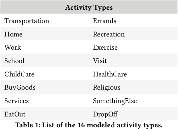
May 24, 2024Abstract:Human mobility significantly impacts various aspects of society, including transportation, urban planning, and public health. The increasing availability of diverse mobility data and advancements in deep learning have revolutionized mobility modeling. Existing deep learning models, however, mainly study spatio-temporal patterns using trajectories and often fall short in capturing the underlying semantic interdependency among activities. Moreover, they are also constrained by the data source. These two factors thereby limit their realism and adaptability, respectively. Meanwhile, traditional activity-based models (ABMs) in transportation modeling rely on rigid assumptions and are costly and time-consuming to calibrate, making them difficult to adapt and scale to new regions, especially those regions with limited amount of required conventional travel data. To address these limitations, we develop a novel generative deep learning approach for human mobility modeling and synthesis, using ubiquitous and open-source data. Additionally, the model can be fine-tuned with local data, enabling adaptable and accurate representations of mobility patterns across different regions. The model is evaluated on a nationwide dataset of the United States, where it demonstrates superior performance in generating activity chains that closely follow ground truth distributions. Further tests using state- or city-specific datasets from California, Washington, and Mexico City confirm its transferability. This innovative approach offers substantial potential to advance mobility modeling research, especially in generating human activity chains as input for downstream activity-based mobility simulation models and providing enhanced tools for urban planners and policymakers.
 Add to Chrome
 Add to Firefox
 Add to Edge