Penghai Wu
A physics-constrained machine learning method for mapping gapless land surface temperature
Jul 03, 2023Abstract:More accurate, spatio-temporally, and physically consistent LST estimation has been a main interest in Earth system research. Developing physics-driven mechanism models and data-driven machine learning (ML) models are two major paradigms for gapless LST estimation, which have their respective advantages and disadvantages. In this paper, a physics-constrained ML model, which combines the strengths in the mechanism model and ML model, is proposed to generate gapless LST with physical meanings and high accuracy. The hybrid model employs ML as the primary architecture, under which the input variable physical constraints are incorporated to enhance the interpretability and extrapolation ability of the model. Specifically, the light gradient-boosting machine (LGBM) model, which uses only remote sensing data as input, serves as the pure ML model. Physical constraints (PCs) are coupled by further incorporating key Community Land Model (CLM) forcing data (cause) and CLM simulation data (effect) as inputs into the LGBM model. This integration forms the PC-LGBM model, which incorporates surface energy balance (SEB) constraints underlying the data in CLM-LST modeling within a biophysical framework. Compared with a pure physical method and pure ML methods, the PC-LGBM model improves the prediction accuracy and physical interpretability of LST. It also demonstrates a good extrapolation ability for the responses to extreme weather cases, suggesting that the PC-LGBM model enables not only empirical learning from data but also rationally derived from theory. The proposed method represents an innovative way to map accurate and physically interpretable gapless LST, and could provide insights to accelerate knowledge discovery in land surface processes and data mining in geographical parameter estimation.
Generating gapless land surface temperature with a high spatio-temporal resolution by fusing multi-source satellite-observed and model-simulated data
Nov 29, 2021


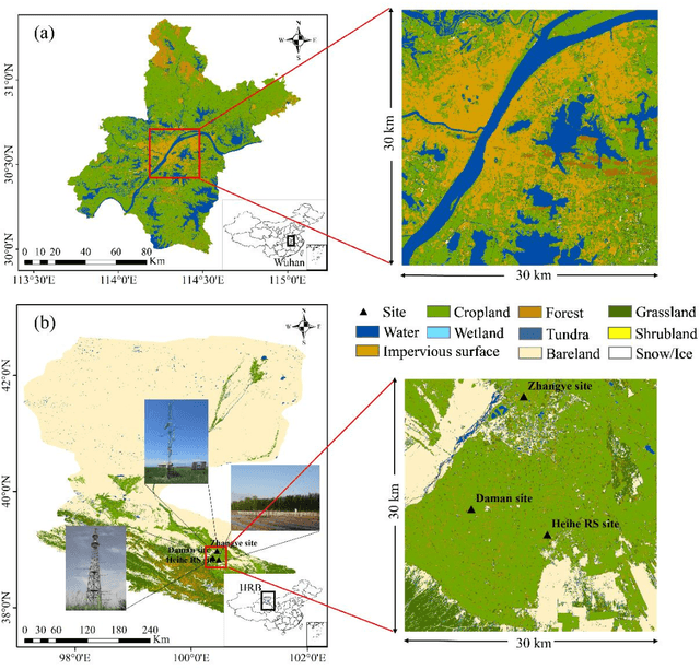
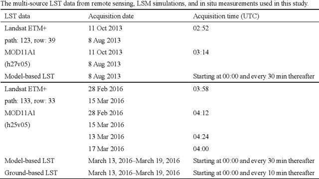
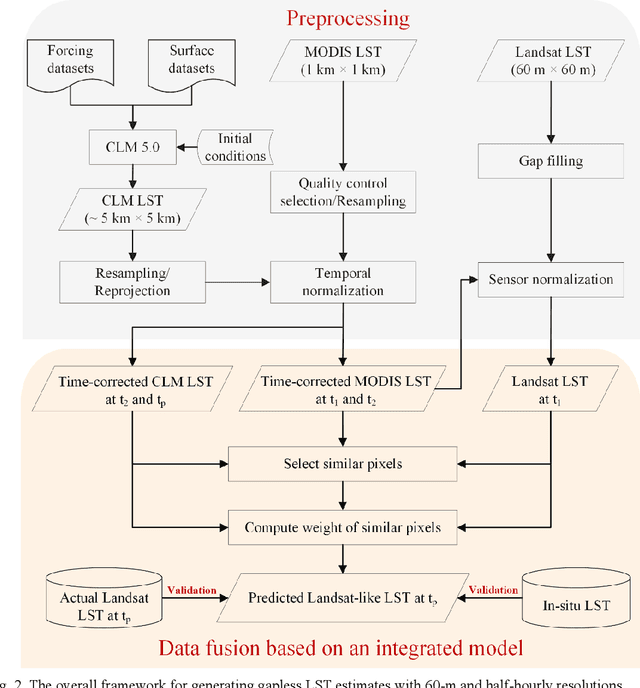
Abstract:Land surface temperature (LST) is a key parameter when monitoring land surface processes. However, cloud contamination and the tradeoff between the spatial and temporal resolutions greatly impede the access to high-quality thermal infrared (TIR) remote sensing data. Despite the massive efforts made to solve these dilemmas, it is still difficult to generate LST estimates with concurrent spatial completeness and a high spatio-temporal resolution. Land surface models (LSMs) can be used to simulate gapless LST with a high temporal resolution, but this usually comes with a low spatial resolution. In this paper, we present an integrated temperature fusion framework for satellite-observed and LSM-simulated LST data to map gapless LST at a 60-m spatial resolution and half-hourly temporal resolution. The global linear model (GloLM) model and the diurnal land surface temperature cycle (DTC) model are respectively performed as preprocessing steps for sensor and temporal normalization between the different LST data. The Landsat LST, Moderate Resolution Imaging Spectroradiometer (MODIS) LST, and Community Land Model Version 5.0 (CLM 5.0)-simulated LST are then fused using a filter-based spatio-temporal integrated fusion model. Evaluations were implemented in an urban-dominated region (the city of Wuhan in China) and a natural-dominated region (the Heihe River Basin in China), in terms of accuracy, spatial variability, and diurnal temporal dynamics. Results indicate that the fused LST is highly consistent with actual Landsat LST data (in situ LST measurements), in terms of a Pearson correlation coefficient of 0.94 (0.97-0.99), a mean absolute error of 0.71-0.98 K (0.82-3.17 K), and a root-mean-square error of 0.97-1.26 K (1.09-3.97 K).
A Spatial and Temporal Non-Local Filter Based Data Fusion
Nov 22, 2016


Abstract:The trade-off in remote sensing instruments that balances the spatial resolution and temporal frequency limits our capacity to monitor spatial and temporal dynamics effectively. The spatiotemporal data fusion technique is considered as a cost-effective way to obtain remote sensing data with both high spatial resolution and high temporal frequency, by blending observations from multiple sensors with different advantages or characteristics. In this paper, we develop the spatial and temporal non-local filter based fusion model (STNLFFM) to enhance the prediction capacity and accuracy, especially for complex changed landscapes. The STNLFFM method provides a new transformation relationship between the fine-resolution reflectance images acquired from the same sensor at different dates with the help of coarse-resolution reflectance data, and makes full use of the high degree of spatiotemporal redundancy in the remote sensing image sequence to produce the final prediction. The proposed method was tested over both the Coleambally Irrigation Area study site and the Lower Gwydir Catchment study site. The results show that the proposed method can provide a more accurate and robust prediction, especially for heterogeneous landscapes and temporally dynamic areas.
 Add to Chrome
 Add to Firefox
 Add to Edge