Miro Miranda
An Analysis of Temporal Dropout in Earth Observation Time Series for Regression Tasks
Apr 09, 2025Abstract:Missing instances in time series data impose a significant challenge to deep learning models, particularly in regression tasks. In the Earth Observation field, satellite failure or cloud occlusion frequently results in missing time-steps, introducing uncertainties in the predicted output and causing a decline in predictive performance. While many studies address missing time-steps through data augmentation to improve model robustness, the uncertainty arising at the input level is commonly overlooked. To address this gap, we introduce Monte Carlo Temporal Dropout (MC-TD), a method that explicitly accounts for input-level uncertainty by randomly dropping time-steps during inference using a predefined dropout ratio, thereby simulating the effect of missing data. To bypass the need for costly searches for the optimal dropout ratio, we extend this approach with Monte Carlo Concrete Temporal Dropout (MC-ConcTD), a method that learns the optimal dropout distribution directly. Both MC-TD and MC-ConcTD are applied during inference, leveraging Monte Carlo sampling for uncertainty quantification. Experiments on three EO time-series datasets demonstrate that MC-ConcTD improves predictive performance and uncertainty calibration compared to existing approaches. Additionally, we highlight the advantages of adaptive dropout tuning over manual selection, making uncertainty quantification more robust and accessible for EO applications.
On What Depends the Robustness of Multi-source Models to Missing Data in Earth Observation?
Mar 25, 2025


Abstract:In recent years, the development of robust multi-source models has emerged in the Earth Observation (EO) field. These are models that leverage data from diverse sources to improve predictive accuracy when there is missing data. Despite these advancements, the factors influencing the varying effectiveness of such models remain poorly understood. In this study, we evaluate the predictive performance of six state-of-the-art multi-source models in predicting scenarios where either a single data source is missing or only a single source is available. Our analysis reveals that the efficacy of these models is intricately tied to the nature of the task, the complementarity among data sources, and the model design. Surprisingly, we observe instances where the removal of certain data sources leads to improved predictive performance, challenging the assumption that incorporating all available data is always beneficial. These findings prompt critical reflections on model complexity and the necessity of all collected data sources, potentially shaping the way for more streamlined approaches in EO applications.
Exploring Physics-Informed Neural Networks for Crop Yield Loss Forecasting
Dec 31, 2024Abstract:In response to climate change, assessing crop productivity under extreme weather conditions is essential to enhance food security. Crop simulation models, which align with physical processes, offer explainability but often perform poorly. Conversely, machine learning (ML) models for crop modeling are powerful and scalable yet operate as black boxes and lack adherence to crop growths physical principles. To bridge this gap, we propose a novel method that combines the strengths of both approaches by estimating the water use and the crop sensitivity to water scarcity at the pixel level. This approach enables yield loss estimation grounded in physical principles by sequentially solving the equation for crop yield response to water scarcity, using an enhanced loss function. Leveraging Sentinel-2 satellite imagery, climate data, simulated water use data, and pixel-level yield data, our model demonstrates high accuracy, achieving an R2 of up to 0.77, matching or surpassing state-of-the-art models like RNNs and Transformers. Additionally, it provides interpretable and physical consistent outputs, supporting industry, policymakers, and farmers in adapting to extreme weather conditions.
* 6 pages, 2 figures, NeurIPS 2024 Workshop on Tackling Climate Change with Machine Learning
Explainability of Sub-Field Level Crop Yield Prediction using Remote Sensing
Jul 11, 2024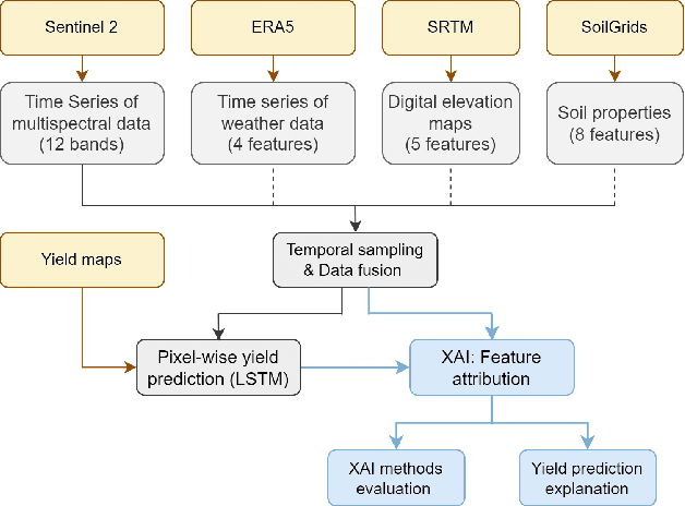
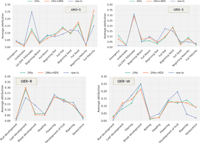
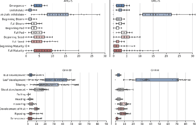
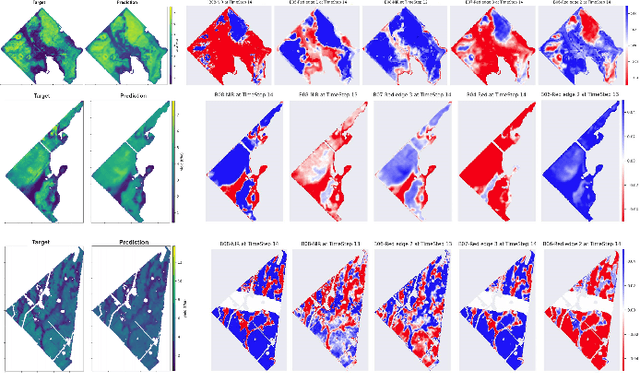
Abstract:Crop yield forecasting plays a significant role in addressing growing concerns about food security and guiding decision-making for policymakers and farmers. When deep learning is employed, understanding the learning and decision-making processes of the models, as well as their interaction with the input data, is crucial for establishing trust in the models and gaining insight into their reliability. In this study, we focus on the task of crop yield prediction, specifically for soybean, wheat, and rapeseed crops in Argentina, Uruguay, and Germany. Our goal is to develop and explain predictive models for these crops, using a large dataset of satellite images, additional data modalities, and crop yield maps. We employ a long short-term memory network and investigate the impact of using different temporal samplings of the satellite data and the benefit of adding more relevant modalities. For model explainability, we utilize feature attribution methods to quantify input feature contributions, identify critical growth stages, analyze yield variability at the field level, and explain less accurate predictions. The modeling results show an improvement when adding more modalities or using all available instances of satellite data. The explainability results reveal distinct feature importance patterns for each crop and region. We further found that the most influential growth stages on the prediction are dependent on the temporal sampling of the input data. We demonstrated how these critical growth stages, which hold significant agronomic value, closely align with the existing literature in agronomy and crop development biology.
Adaptive Fusion of Multi-view Remote Sensing data for Optimal Sub-field Crop Yield Prediction
Jan 22, 2024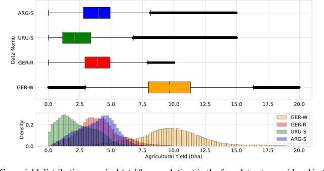

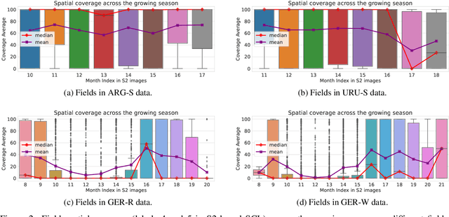

Abstract:Accurate crop yield prediction is of utmost importance for informed decision-making in agriculture, aiding farmers, and industry stakeholders. However, this task is complex and depends on multiple factors, such as environmental conditions, soil properties, and management practices. Combining heterogeneous data views poses a fusion challenge, like identifying the view-specific contribution to the predictive task. We present a novel multi-view learning approach to predict crop yield for different crops (soybean, wheat, rapeseed) and regions (Argentina, Uruguay, and Germany). Our multi-view input data includes multi-spectral optical images from Sentinel-2 satellites and weather data as dynamic features during the crop growing season, complemented by static features like soil properties and topographic information. To effectively fuse the data, we introduce a Multi-view Gated Fusion (MVGF) model, comprising dedicated view-encoders and a Gated Unit (GU) module. The view-encoders handle the heterogeneity of data sources with varying temporal resolutions by learning a view-specific representation. These representations are adaptively fused via a weighted sum. The fusion weights are computed for each sample by the GU using a concatenation of the view-representations. The MVGF model is trained at sub-field level with 10 m resolution pixels. Our evaluations show that the MVGF outperforms conventional models on the same task, achieving the best results by incorporating all the data sources, unlike the usual fusion results in the literature. For Argentina, the MVGF model achieves an R2 value of 0.68 at sub-field yield prediction, while at field level evaluation (comparing field averages), it reaches around 0.80 across different countries. The GU module learned different weights based on the country and crop-type, aligning with the variable significance of each data source to the prediction task.
Predicting Crop Yield With Machine Learning: An Extensive Analysis Of Input Modalities And Models On a Field and sub-field Level
Aug 17, 2023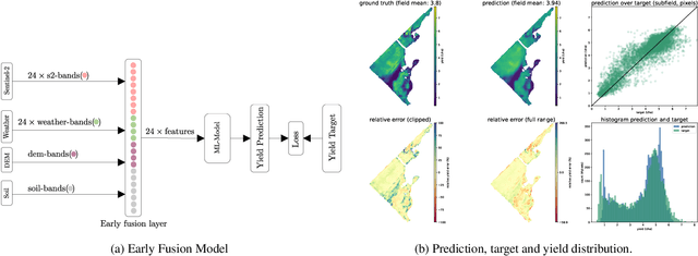


Abstract:We introduce a simple yet effective early fusion method for crop yield prediction that handles multiple input modalities with different temporal and spatial resolutions. We use high-resolution crop yield maps as ground truth data to train crop and machine learning model agnostic methods at the sub-field level. We use Sentinel-2 satellite imagery as the primary modality for input data with other complementary modalities, including weather, soil, and DEM data. The proposed method uses input modalities available with global coverage, making the framework globally scalable. We explicitly highlight the importance of input modalities for crop yield prediction and emphasize that the best-performing combination of input modalities depends on region, crop, and chosen model.
 Add to Chrome
 Add to Firefox
 Add to Edge