 Add to Chrome
 Add to Firefox
 Add to Edge
GiGL: Large-Scale Graph Neural Networks at Snapchat
Feb 20, 2025Recent advances in graph machine learning (ML) with the introduction of Graph Neural Networks (GNNs) have led to a widespread interest in applying these approaches to business applications at scale. GNNs enable differentiable end-to-end (E2E) learning of model parameters given graph structure which enables optimization towards popular node, edge (link) and graph-level tasks. While the research innovation in new GNN layers and training strategies has been rapid, industrial adoption and utility of GNNs has lagged considerably due to the unique scale challenges that large-scale graph ML problems create. In this work, we share our approach to training, inference, and utilization of GNNs at Snapchat. To this end, we present GiGL (Gigantic Graph Learning), an open-source library to enable large-scale distributed graph ML to the benefit of researchers, ML engineers, and practitioners. We use GiGL internally at Snapchat to manage the heavy lifting of GNN workflows, including graph data preprocessing from relational DBs, subgraph sampling, distributed training, inference, and orchestration. GiGL is designed to interface cleanly with open-source GNN modeling libraries prominent in academia like PyTorch Geometric (PyG), while handling scaling and productionization challenges that make it easier for internal practitioners to focus on modeling. GiGL is used in multiple production settings, and has powered over 35 launches across multiple business domains in the last 2 years in the contexts of friend recommendation, content recommendation and advertising. This work details high-level design and tools the library provides, scaling properties, case studies in diverse business settings with industry-scale graphs, and several key lessons learned in employing graph ML at scale on large social data. GiGL is open-sourced at https://github.com/snap-research/GiGL.
Building Coverage Estimation with Low-resolution Remote Sensing Imagery
Jan 05, 2023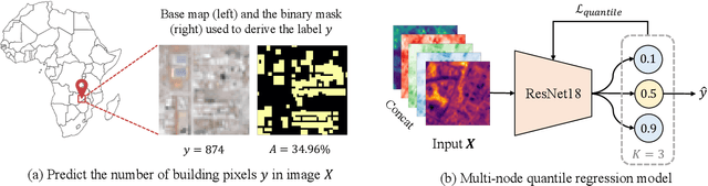


Building coverage statistics provide crucial insights into the urbanization, infrastructure, and poverty level of a region, facilitating efforts towards alleviating poverty, building sustainable cities, and allocating infrastructure investments and public service provision. Global mapping of buildings has been made more efficient with the incorporation of deep learning models into the pipeline. However, these models typically rely on high-resolution satellite imagery which are expensive to collect and infrequently updated. As a result, building coverage data are not updated timely especially in developing regions where the built environment is changing quickly. In this paper, we propose a method for estimating building coverage using only publicly available low-resolution satellite imagery that is more frequently updated. We show that having a multi-node quantile regression layer greatly improves the model's spatial and temporal generalization. Our model achieves a coefficient of determination ($R^2$) as high as 0.968 on predicting building coverage in regions of different levels of development around the world. We demonstrate that the proposed model accurately predicts the building coverage from raw input images and generalizes well to unseen countries and continents, suggesting the possibility of estimating global building coverage using only low-resolution remote sensing data.