Lanying Wang
Trustworthy Data-Driven Wildfire Risk Prediction and Understanding in Western Canada
Jan 04, 2026Abstract:In recent decades, the intensification of wildfire activity in western Canada has resulted in substantial socio-economic and environmental losses. Accurate wildfire risk prediction is hindered by the intrinsic stochasticity of ignition and spread and by nonlinear interactions among fuel conditions, meteorology, climate variability, topography, and human activities, challenging the reliability and interpretability of purely data-driven models. We propose a trustworthy data-driven wildfire risk prediction framework based on long-sequence, multi-scale temporal modeling, which integrates heterogeneous drivers while explicitly quantifying predictive uncertainty and enabling process-level interpretation. Evaluated over western Canada during the record-breaking 2023 and 2024 fire seasons, the proposed model outperforms existing time-series approaches, achieving an F1 score of 0.90 and a PR-AUC of 0.98 with low computational cost. Uncertainty-aware analysis reveals structured spatial and seasonal patterns in predictive confidence, highlighting increased uncertainty associated with ambiguous predictions and spatiotemporal decision boundaries. SHAP-based interpretation provides mechanistic understanding of wildfire controls, showing that temperature-related drivers dominate wildfire risk in both years, while moisture-related constraints play a stronger role in shaping spatial and land-cover-specific contrasts in 2024 compared to the widespread hot and dry conditions of 2023. Data and code are available at https://github.com/SynUW/mmFire.
Multi-view X-ray Image Synthesis with Multiple Domain Disentanglement from CT Scans
Apr 18, 2024


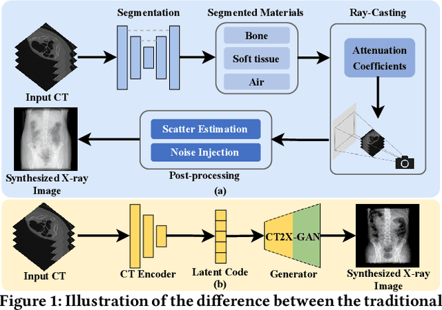
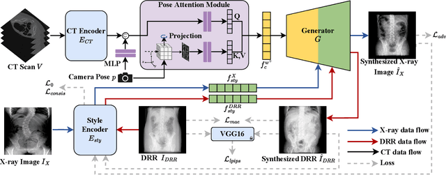
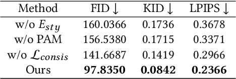
Abstract:X-ray images play a vital role in the intraoperative processes due to their high resolution and fast imaging speed and greatly promote the subsequent segmentation, registration and reconstruction. However, over-dosed X-rays superimpose potential risks to human health to some extent. Data-driven algorithms from volume scans to X-ray images are restricted by the scarcity of paired X-ray and volume data. Existing methods are mainly realized by modelling the whole X-ray imaging procedure. In this study, we propose a learning-based approach termed CT2X-GAN to synthesize the X-ray images in an end-to-end manner using the content and style disentanglement from three different image domains. Our method decouples the anatomical structure information from CT scans and style information from unpaired real X-ray images/ digital reconstructed radiography (DRR) images via a series of decoupling encoders. Additionally, we introduce a novel consistency regularization term to improve the stylistic resemblance between synthesized X-ray images and real X-ray images. Meanwhile, we also impose a supervised process by computing the similarity of computed real DRR and synthesized DRR images. We further develop a pose attention module to fully strengthen the comprehensive information in the decoupled content code from CT scans, facilitating high-quality multi-view image synthesis in the lower 2D space. Extensive experiments were conducted on the publicly available CTSpine1K dataset and achieved 97.8350, 0.0842 and 3.0938 in terms of FID, KID and defined user-scored X-ray similarity, respectively. In comparison with 3D-aware methods ($\pi$-GAN, EG3D), CT2X-GAN is superior in improving the synthesis quality and realistic to the real X-ray images.
Monitoring surface deformation over oilfield using MT-InSAR and production well data
Mar 18, 2021


Abstract:Surface displacements associated with the average subsidence due to hydrocarbon exploitation in southwest of Iran which has a long history in oil production, can lead to significant damages to surface and subsurface structures, and requires serious consideration. In this study, the Small BAseline Subset (SBAS) approach, which is a multi-temporal Interferometric Synthetic Aperture Radar (InSAR) algorithm was employed to resolve ground deformation in the Marun region, Iran. A total of 22 interferograms were generated using 10 Envisat ASAR images. The mean velocity map obtained in the Line-Of-Sight (LOS) direction of satellite to the ground reveals the maximum subsidence on order of 13.5 mm per year over the field due to both tectonic and non-tectonic features. In order to assess the effect of non-tectonic features such as petroleum extraction on ground surface displacement, the results of InSAR have been compared with the oil production rate, which have shown a good agreement.
UAV LiDAR Point Cloud Segmentation of A Stack Interchange with Deep Neural Networks
Oct 21, 2020Abstract:Stack interchanges are essential components of transportation systems. Mobile laser scanning (MLS) systems have been widely used in road infrastructure mapping, but accurate mapping of complicated multi-layer stack interchanges are still challenging. This study examined the point clouds collected by a new Unmanned Aerial Vehicle (UAV) Light Detection and Ranging (LiDAR) system to perform the semantic segmentation task of a stack interchange. An end-to-end supervised 3D deep learning framework was proposed to classify the point clouds. The proposed method has proven to capture 3D features in complicated interchange scenarios with stacked convolution and the result achieved over 93% classification accuracy. In addition, the new low-cost semi-solid-state LiDAR sensor Livox Mid-40 featuring a incommensurable rosette scanning pattern has demonstrated its potential in high-definition urban mapping.
 Add to Chrome
 Add to Firefox
 Add to Edge