Kristin Dana
YOPO-Nav: Visual Navigation using 3DGS Graphs from One-Pass Videos
Dec 10, 2025


Abstract:Visual navigation has emerged as a practical alternative to traditional robotic navigation pipelines that rely on detailed mapping and path planning. However, constructing and maintaining 3D maps is often computationally expensive and memory-intensive. We address the problem of visual navigation when exploration videos of a large environment are available. The videos serve as a visual reference, allowing a robot to retrace the explored trajectories without relying on metric maps. Our proposed method, YOPO-Nav (You Only Pass Once), encodes an environment into a compact spatial representation composed of interconnected local 3D Gaussian Splatting (3DGS) models. During navigation, the framework aligns the robot's current visual observation with this representation and predicts actions that guide it back toward the demonstrated trajectory. YOPO-Nav employs a hierarchical design: a visual place recognition (VPR) module provides coarse localization, while the local 3DGS models refine the goal and intermediate poses to generate control actions. To evaluate our approach, we introduce the YOPO-Campus dataset, comprising 4 hours of egocentric video and robot controller inputs from over 6 km of human-teleoperated robot trajectories. We benchmark recent visual navigation methods on trajectories from YOPO-Campus using a Clearpath Jackal robot. Experimental results show YOPO-Nav provides excellent performance in image-goal navigation for real-world scenes on a physical robot. The dataset and code will be made publicly available for visual navigation and scene representation research.
EgoCampus: Egocentric Pedestrian Eye Gaze Model and Dataset
Dec 08, 2025Abstract:We address the challenge of predicting human visual attention during real-world navigation by measuring and modeling egocentric pedestrian eye gaze in an outdoor campus setting. We introduce the EgoCampus dataset, which spans 25 unique outdoor paths over 6 km across a university campus with recordings from more than 80 distinct human pedestrians, resulting in a diverse set of gaze-annotated videos. The system used for collection, Meta's Project Aria glasses, integrates eye tracking, front-facing RGB cameras, inertial sensors, and GPS to provide rich data from the human perspective. Unlike many prior egocentric datasets that focus on indoor tasks or exclude eye gaze information, our work emphasizes visual attention while subjects walk in outdoor campus paths. Using this data, we develop EgoCampusNet, a novel method to predict eye gaze of navigating pedestrians as they move through outdoor environments. Our contributions provide both a new resource for studying real-world attention and a resource for future work in gaze prediction models for navigation. Dataset and code are available upon request, and will be made publicly available at a later date at https://github.com/ComputerVisionRutgers/EgoCampus .
Agtech Framework for Cranberry-Ripening Analysis Using Vision Foundation Models
Dec 12, 2024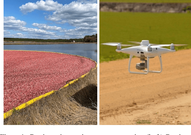
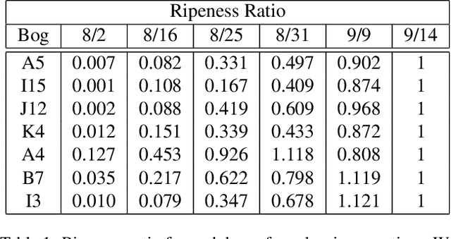
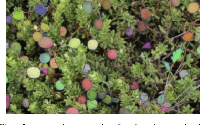
Abstract:Agricultural domains are being transformed by recent advances in AI and computer vision that support quantitative visual evaluation. Using aerial and ground imaging over a time series, we develop a framework for characterizing the ripening process of cranberry crops, a crucial component for precision agriculture tasks such as comparing crop breeds (high-throughput phenotyping) and detecting disease. Using drone imaging, we capture images from 20 waypoints across multiple bogs, and using ground-based imaging (hand-held camera), we image same bog patch using fixed fiducial markers. Both imaging methods are repeated to gather a multi-week time series spanning the entire growing season. Aerial imaging provides multiple samples to compute a distribution of albedo values. Ground imaging enables tracking of individual berries for a detailed view of berry appearance changes. Using vision transformers (ViT) for feature detection after segmentation, we extract a high dimensional feature descriptor of berry appearance. Interpretability of appearance is critical for plant biologists and cranberry growers to support crop breeding decisions (e.g.\ comparison of berry varieties from breeding programs). For interpretability, we create a 2D manifold of cranberry appearance by using a UMAP dimensionality reduction on ViT features. This projection enables quantification of ripening paths and a useful metric of ripening rate. We demonstrate the comparison of four cranberry varieties based on our ripening assessments. This work is the first of its kind and has future impact for cranberries and for other crops including wine grapes, olives, blueberries, and maize. Aerial and ground datasets are made publicly available.
Memory Proxy Maps for Visual Navigation
Nov 15, 2024


Abstract:Visual navigation takes inspiration from humans, who navigate in previously unseen environments using vision without detailed environment maps. Inspired by this, we introduce a novel no-RL, no-graph, no-odometry approach to visual navigation using feudal learning to build a three tiered agent. Key to our approach is a memory proxy map (MPM), an intermediate representation of the environment learned in a self-supervised manner by the high-level manager agent that serves as a simplified memory, approximating what the agent has seen. We demonstrate that recording observations in this learned latent space is an effective and efficient memory proxy that can remove the need for graphs and odometry in visual navigation tasks. For the mid-level manager agent, we develop a waypoint network (WayNet) that outputs intermediate subgoals, or waypoints, imitating human waypoint selection during local navigation. For the low-level worker agent, we learn a classifier over a discrete action space that avoids local obstacles and moves the agent towards the WayNet waypoint. The resulting feudal navigation network offers a novel approach with no RL, no graph, no odometry, and no metric map; all while achieving SOTA results on the image goal navigation task.
A Landmark-Aware Visual Navigation Dataset
Feb 22, 2024


Abstract:Map representation learned by expert demonstrations has shown promising research value. However, recent advancements in the visual navigation field face challenges due to the lack of human datasets in the real world for efficient supervised representation learning of the environments. We present a Landmark-Aware Visual Navigation (LAVN) dataset to allow for supervised learning of human-centric exploration policies and map building. We collect RGB observation and human point-click pairs as a human annotator explores virtual and real-world environments with the goal of full coverage exploration of the space. The human annotators also provide distinct landmark examples along each trajectory, which we intuit will simplify the task of map or graph building and localization. These human point-clicks serve as direct supervision for waypoint prediction when learning to explore in environments. Our dataset covers a wide spectrum of scenes, including rooms in indoor environments, as well as walkways outdoors. Dataset is available at DOI: 10.5281/zenodo.10608067.
Feudal Networks for Visual Navigation
Feb 19, 2024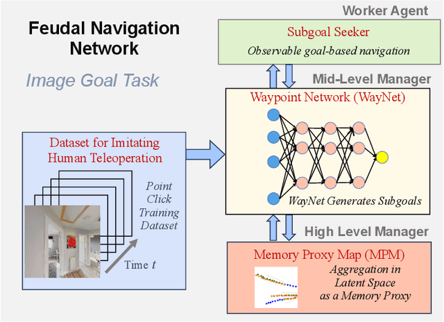

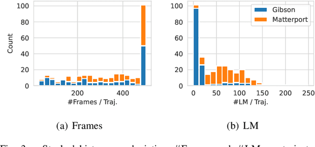
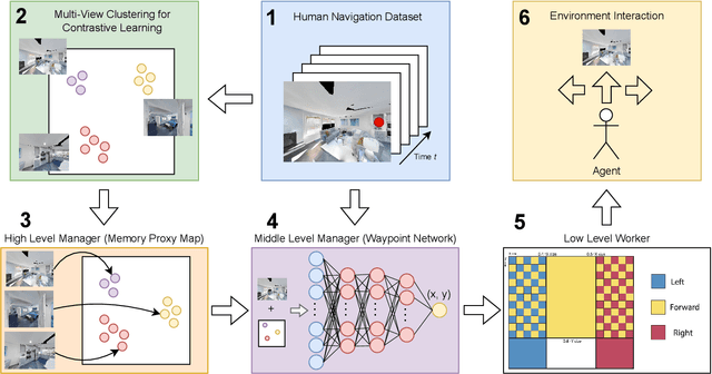
Abstract:Visual navigation follows the intuition that humans can navigate without detailed maps. A common approach is interactive exploration while building a topological graph with images at nodes that can be used for planning. Recent variations learn from passive videos and can navigate using complex social and semantic cues. However, a significant number of training videos are needed, large graphs are utilized, and scenes are not unseen since odometry is utilized. We introduce a new approach to visual navigation using feudal learning, which employs a hierarchical structure consisting of a worker agent, a mid-level manager, and a high-level manager. Key to the feudal learning paradigm, agents at each level see a different aspect of the task and operate at different spatial and temporal scales. Two unique modules are developed in this framework. For the high-level manager, we learn a memory proxy map in a self supervised manner to record prior observations in a learned latent space and avoid the use of graphs and odometry. For the mid-level manager, we develop a waypoint network that outputs intermediate subgoals imitating human waypoint selection during local navigation. This waypoint network is pre-trained using a new, small set of teleoperation videos that we make publicly available, with training environments different from testing environments. The resulting feudal navigation network achieves near SOTA performance, while providing a novel no-RL, no-graph, no-odometry, no-metric map approach to the image goal navigation task.
Hierarchical Reinforcement Learning for Temporal Pattern Prediction
Oct 09, 2023Abstract:In this work, we explore the use of hierarchical reinforcement learning (HRL) for the task of temporal sequence prediction. Using a combination of deep learning and HRL, we develop a stock agent to predict temporal price sequences from historical stock price data and a vehicle agent to predict steering angles from first person, dash cam images. Our results in both domains indicate that a type of HRL, called feudal reinforcement learning, provides significant improvements to training speed and stability and prediction accuracy over standard RL. A key component to this success is the multi-resolution structure that introduces both temporal and spatial abstraction into the network hierarchy.
ViFiT: Reconstructing Vision Trajectories from IMU and Wi-Fi Fine Time Measurements
Oct 04, 2023Abstract:Tracking subjects in videos is one of the most widely used functions in camera-based IoT applications such as security surveillance, smart city traffic safety enhancement, vehicle to pedestrian communication and so on. In the computer vision domain, tracking is usually achieved by first detecting subjects with bounding boxes, then associating detected bounding boxes across video frames. For many IoT systems, images captured by cameras are usually sent over the network to be processed at a different site that has more powerful computing resources than edge devices. However, sending entire frames through the network causes significant bandwidth consumption that may exceed the system bandwidth constraints. To tackle this problem, we propose ViFiT, a transformer-based model that reconstructs vision bounding box trajectories from phone data (IMU and Fine Time Measurements). It leverages a transformer ability of better modeling long-term time series data. ViFiT is evaluated on Vi-Fi Dataset, a large-scale multimodal dataset in 5 diverse real world scenes, including indoor and outdoor environments. To fill the gap of proper metrics of jointly capturing the system characteristics of both tracking quality and video bandwidth reduction, we propose a novel evaluation framework dubbed Minimum Required Frames (MRF) and Minimum Required Frames Ratio (MRFR). ViFiT achieves an MRFR of 0.65 that outperforms the state-of-the-art approach for cross-modal reconstruction in LSTM Encoder-Decoder architecture X-Translator of 0.98, resulting in a high frame reduction rate as 97.76%.
Vision-Based Cranberry Crop Ripening Assessment
Aug 31, 2023

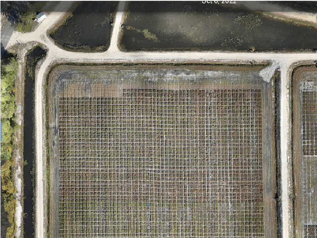
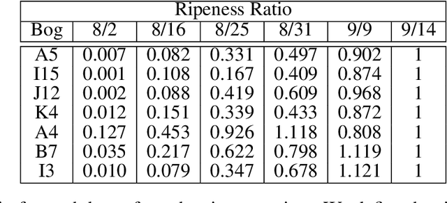
Abstract:Agricultural domains are being transformed by recent advances in AI and computer vision that support quantitative visual evaluation. Using drone imaging, we develop a framework for characterizing the ripening process of cranberry crops. Our method consists of drone-based time-series collection over a cranberry growing season, photometric calibration for albedo recovery from pixels, and berry segmentation with semi-supervised deep learning networks using point-click annotations. By extracting time-series berry albedo measurements, we evaluate four different varieties of cranberries and provide a quantification of their ripening rates. Such quantification has practical implications for 1) assessing real-time overheating risks for cranberry bogs; 2) large scale comparisons of progeny in crop breeding; 3) detecting disease by looking for ripening pattern outliers. This work is the first of its kind in quantitative evaluation of ripening using computer vision methods and has impact beyond cranberry crops including wine grapes, olives, blueberries, and maize.
Learning a Pedestrian Social Behavior Dictionary
Dec 02, 2022


Abstract:Understanding pedestrian behavior patterns is a key component to building autonomous agents that can navigate among humans. We seek a learned dictionary of pedestrian behavior to obtain a semantic description of pedestrian trajectories. Supervised methods for dictionary learning are impractical since pedestrian behaviors may be unknown a priori and the process of manually generating behavior labels is prohibitively time consuming. We instead utilize a novel, unsupervised framework to create a taxonomy of pedestrian behavior observed in a specific space. First, we learn a trajectory latent space that enables unsupervised clustering to create an interpretable pedestrian behavior dictionary. We show the utility of this dictionary for building pedestrian behavior maps to visualize space usage patterns and for computing the distributions of behaviors. We demonstrate a simple but effective trajectory prediction by conditioning on these behavior labels. While many trajectory analysis methods rely on RNNs or transformers, we develop a lightweight, low-parameter approach and show results comparable to SOTA on the ETH and UCY datasets.
 Add to Chrome
 Add to Firefox
 Add to Edge