Ibrahim Fayad
UMR TETIS
SERA-H: Beyond Native Sentinel Spatial Limits for High-Resolution Canopy Height Mapping
Dec 19, 2025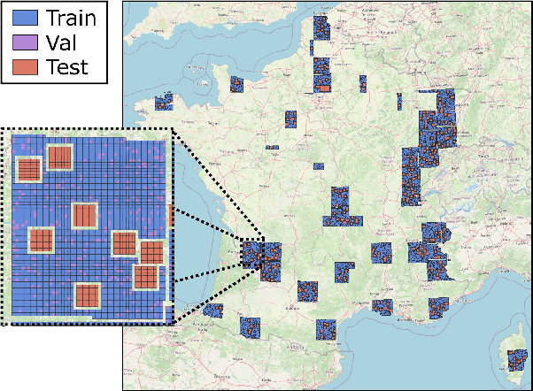
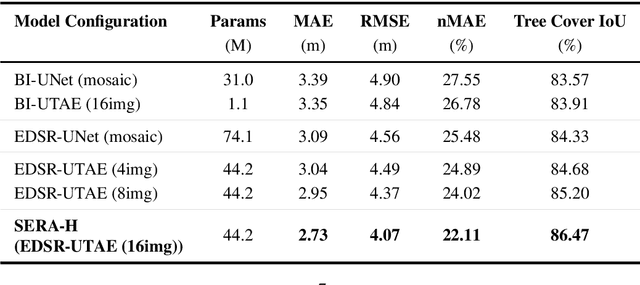

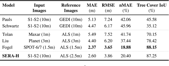
Abstract:High-resolution mapping of canopy height is essential for forest management and biodiversity monitoring. Although recent studies have led to the advent of deep learning methods using satellite imagery to predict height maps, these approaches often face a trade-off between data accessibility and spatial resolution. To overcome these limitations, we present SERA-H, an end-to-end model combining a super-resolution module (EDSR) and temporal attention encoding (UTAE). Trained under the supervision of high-density LiDAR data (ALS), our model generates 2.5 m resolution height maps from freely available Sentinel-1 and Sentinel-2 (10 m) time series data. Evaluated on an open-source benchmark dataset in France, SERA-H, with a MAE of 2.6 m and a coefficient of determination of 0.82, not only outperforms standard Sentinel-1/2 baselines but also achieves performance comparable to or better than methods relying on commercial very high-resolution imagery (SPOT-6/7, PlanetScope, Maxar). These results demonstrate that combining high-resolution supervision with the spatiotemporal information embedded in time series enables the reconstruction of details beyond the input sensors' native resolution. SERA-H opens the possibility of freely mapping forests with high revisit frequency, achieving accuracy comparable to that of costly commercial imagery. The source code is available at https://github.com/ThomasBoudras/SERA-H#
DUNIA: Pixel-Sized Embeddings via Cross-Modal Alignment for Earth Observation Applications
Feb 24, 2025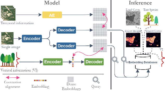

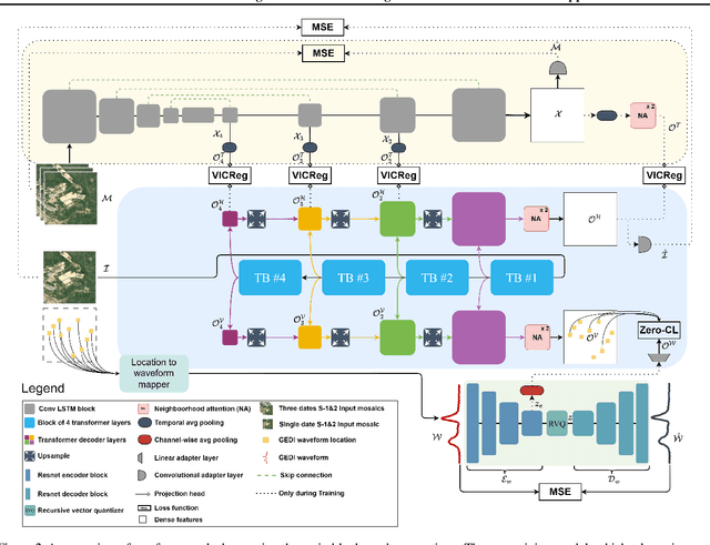

Abstract:Significant efforts have been directed towards adapting self-supervised multimodal learning for Earth observation applications. However, existing methods produce coarse patch-sized embeddings, limiting their effectiveness and integration with other modalities like LiDAR. To close this gap, we present DUNIA, an approach to learn pixel-sized embeddings through cross-modal alignment between images and full-waveform LiDAR data. As the model is trained in a contrastive manner, the embeddings can be directly leveraged in the context of a variety of environmental monitoring tasks in a zero-shot setting. In our experiments, we demonstrate the effectiveness of the embeddings for seven such tasks (canopy height mapping, fractional canopy cover, land cover mapping, tree species identification, plant area index, crop type classification, and per-pixel waveform-based vertical structure mapping). The results show that the embeddings, along with zero-shot classifiers, often outperform specialized supervised models, even in low data regimes. In the fine-tuning setting, we show strong low-shot capabilities with performances near or better than state-of-the-art on five out of six tasks.
Open-Canopy: A Country-Scale Benchmark for Canopy Height Estimation at Very High Resolution
Jul 12, 2024


Abstract:Estimating canopy height and canopy height change at meter resolution from satellite imagery has numerous applications, such as monitoring forest health, logging activities, wood resources, and carbon stocks. However, many existing forest datasets are based on commercial or closed data sources, restricting the reproducibility and evaluation of new approaches. To address this gap, we introduce Open-Canopy, the first open-access and country-scale benchmark for very high resolution (1.5 m) canopy height estimation. Covering more than 87,000 km$^2$ across France, Open-Canopy combines SPOT satellite imagery with high resolution aerial LiDAR data. We also propose Open-Canopy-$\Delta$, the first benchmark for canopy height change detection between two images taken at different years, a particularly challenging task even for recent models. To establish a robust foundation for these benchmarks, we evaluate a comprehensive list of state-of-the-art computer vision models for canopy height estimation. The dataset and associated codes can be accessed at https://github.com/fajwel/Open-Canopy.
Vision Transformers, a new approach for high-resolution and large-scale mapping of canopy heights
Apr 22, 2023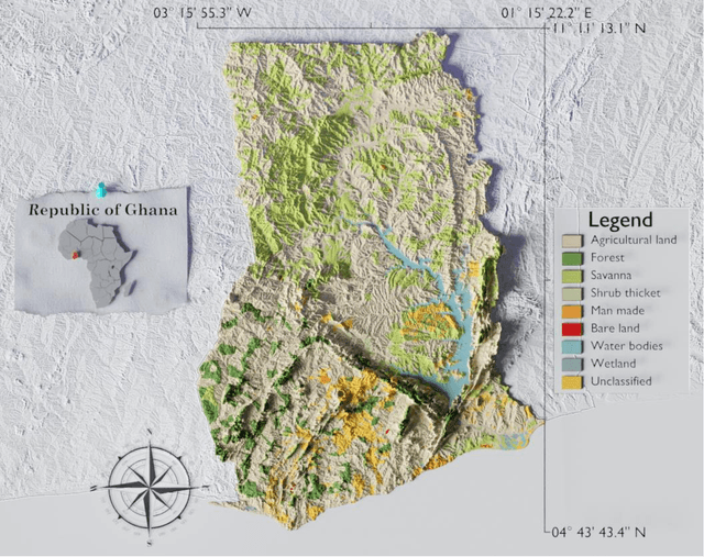

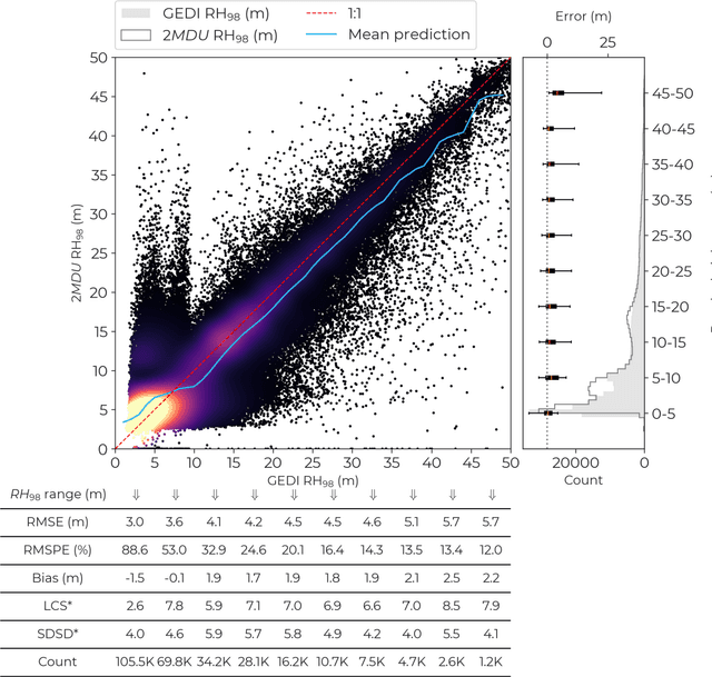
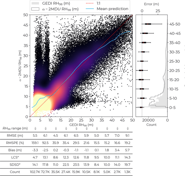
Abstract:Accurate and timely monitoring of forest canopy heights is critical for assessing forest dynamics, biodiversity, carbon sequestration as well as forest degradation and deforestation. Recent advances in deep learning techniques, coupled with the vast amount of spaceborne remote sensing data offer an unprecedented opportunity to map canopy height at high spatial and temporal resolutions. Current techniques for wall-to-wall canopy height mapping correlate remotely sensed 2D information from optical and radar sensors to the vertical structure of trees using LiDAR measurements. While studies using deep learning algorithms have shown promising performances for the accurate mapping of canopy heights, they have limitations due to the type of architectures and loss functions employed. Moreover, mapping canopy heights over tropical forests remains poorly studied, and the accurate height estimation of tall canopies is a challenge due to signal saturation from optical and radar sensors, persistent cloud covers and sometimes the limited penetration capabilities of LiDARs. Here, we map heights at 10 m resolution across the diverse landscape of Ghana with a new vision transformer (ViT) model optimized concurrently with a classification (discrete) and a regression (continuous) loss function. This model achieves better accuracy than previously used convolutional based approaches (ConvNets) optimized with only a continuous loss function. The ViT model results show that our proposed discrete/continuous loss significantly increases the sensitivity for very tall trees (i.e., > 35m), for which other approaches show saturation effects. The height maps generated by the ViT also have better ground sampling distance and better sensitivity to sparse vegetation in comparison to a convolutional model. Our ViT model has a RMSE of 3.12m in comparison to a reference dataset while the ConvNet model has a RMSE of 4.3m.
High-resolution canopy height map in the Landes forest based on GEDI, Sentinel-1, and Sentinel-2 data with a deep learning approach
Dec 20, 2022Abstract:In intensively managed forests in Europe, where forests are divided into stands of small size and may show heterogeneity within stands, a high spatial resolution (10 - 20 meters) is arguably needed to capture the differences in canopy height. In this work, we developed a deep learning model based on multi-stream remote sensing measurements to create a high-resolution canopy height map over the "Landes de Gascogne" forest in France, a large maritime pine plantation of 13,000 km$^2$ with flat terrain and intensive management. This area is characterized by even-aged and mono-specific stands, of a typical length of a few hundred meters, harvested every 35 to 50 years. Our deep learning U-Net model uses multi-band images from Sentinel-1 and Sentinel-2 with composite time averages as input to predict tree height derived from GEDI waveforms. The evaluation is performed with external validation data from forest inventory plots and a stereo 3D reconstruction model based on Skysat imagery available at specific locations. We trained seven different U-net models based on a combination of Sentinel-1 and Sentinel-2 bands to evaluate the importance of each instrument in the dominant height retrieval. The model outputs allow us to generate a 10 m resolution canopy height map of the whole "Landes de Gascogne" forest area for 2020 with a mean absolute error of 2.02 m on the Test dataset. The best predictions were obtained using all available satellite layers from Sentinel-1 and Sentinel-2 but using only one satellite source also provided good predictions. For all validation datasets in coniferous forests, our model showed better metrics than previous canopy height models available in the same region.
Aboveground biomass mapping in French Guiana by combining remote sensing, forest inventories and environmental data
Oct 14, 2016


Abstract:Mapping forest aboveground biomass (AGB) has become an important task, particularly for the reporting of carbon stocks and changes. AGB can be mapped using synthetic aperture radar data (SAR) or passive optical data. However, these data are insensitive to high AGB levels (\textgreater{}150 Mg/ha, and \textgreater{}300 Mg/ha for P-band), which are commonly found in tropical forests. Studies have mapped the rough variations in AGB by combining optical and environmental data at regional and global scales. Nevertheless, these maps cannot represent local variations in AGB in tropical forests. In this paper, we hypothesize that the problem of misrepresenting local variations in AGB and AGB estimation with good precision occurs because of both methodological limits (signal saturation or dilution bias) and a lack of adequate calibration data in this range of AGB values. We test this hypothesis by developing a calibrated regression model to predict variations in high AGB values (mean \textgreater{}300 Mg/ha) in French Guiana by a methodological approach for spatial extrapolation with data from the optical geoscience laser altimeter system (GLAS), forest inventories, radar, optics, and environmental variables for spatial inter-and extrapolation. Given their higher point count, GLAS data allow a wider coverage of AGB values. We find that the metrics from GLAS footprints are correlated with field AGB estimations (R 2 =0.54, RMSE=48.3 Mg/ha) with no bias for high values. First, predictive models, including remote-sensing, environmental variables and spatial correlation functions, allow us to obtain "wall-to-wall" AGB maps over French Guiana with an RMSE for the in situ AGB estimates of ~51 Mg/ha and R${}^2$=0.48 at a 1-km grid size. We conclude that a calibrated regression model based on GLAS with dependent environmental data can produce good AGB predictions even for high AGB values if the calibration data fit the AGB range. We also demonstrate that small temporal and spatial mismatches between field data and GLAS footprints are not a problem for regional and global calibrated regression models because field data aim to predict large and deep tendencies in AGB variations from environmental gradients and do not aim to represent high but stochastic and temporally limited variations from forest dynamics. Thus, we advocate including a greater variety of data, even if less precise and shifted, to better represent high AGB values in global models and to improve the fitting of these models for high values.
 Add to Chrome
 Add to Firefox
 Add to Edge