Ariane Middel
MNIST-Gen: A Modular MNIST-Style Dataset Generation Using Hierarchical Semantics, Reinforcement Learning, and Category Theory
Jul 16, 2025Abstract:Neural networks are often benchmarked using standard datasets such as MNIST, FashionMNIST, or other variants of MNIST, which, while accessible, are limited to generic classes such as digits or clothing items. For researchers working on domain-specific tasks, such as classifying trees, food items, or other real-world objects, these data sets are insufficient and irrelevant. Additionally, creating and publishing a custom dataset can be time consuming, legally constrained, or beyond the scope of individual projects. We present MNIST-Gen, an automated, modular, and adaptive framework for generating MNIST-style image datasets tailored to user-specified categories using hierarchical semantic categorization. The system combines CLIP-based semantic understanding with reinforcement learning and human feedback to achieve intelligent categorization with minimal manual intervention. Our hierarchical approach supports complex category structures with semantic characteristics, enabling fine-grained subcategorization and multiple processing modes: individual review for maximum control, smart batch processing for large datasets, and fast batch processing for rapid creation. Inspired by category theory, MNIST-Gen models each data transformation stage as a composable morphism, enhancing clarity, modularity, and extensibility. As proof of concept, we generate and benchmark two novel datasets-\textit{Tree-MNIST} and \textit{Food-MNIST}-demonstrating MNIST-Gen's utility for producing task-specific evaluation data while achieving 85\% automatic categorization accuracy and 80\% time savings compared to manual approaches.
MID-L: Matrix-Interpolated Dropout Layer with Layer-wise Neuron Selection
May 16, 2025Abstract:Modern neural networks often activate all neurons for every input, leading to unnecessary computation and inefficiency. We introduce Matrix-Interpolated Dropout Layer (MID-L), a novel module that dynamically selects and activates only the most informative neurons by interpolating between two transformation paths via a learned, input-dependent gating vector. Unlike conventional dropout or static sparsity methods, MID-L employs a differentiable Top-k masking strategy, enabling per-input adaptive computation while maintaining end-to-end differentiability. MID-L is model-agnostic and integrates seamlessly into existing architectures. Extensive experiments on six benchmarks, including MNIST, CIFAR-10, CIFAR-100, SVHN, UCI Adult, and IMDB, show that MID-L achieves up to average 55\% reduction in active neurons, 1.7$\times$ FLOPs savings, and maintains or exceeds baseline accuracy. We further validate the informativeness and selectivity of the learned neurons via Sliced Mutual Information (SMI) and observe improved robustness under overfitting and noisy data conditions. Additionally, MID-L demonstrates favorable inference latency and memory usage profiles, making it suitable for both research exploration and deployment on compute-constrained systems. These results position MID-L as a general-purpose, plug-and-play dynamic computation layer, bridging the gap between dropout regularization and efficient inference.
A Multimodal Physics-Informed Neural Network Approach for Mean Radiant Temperature Modeling
Mar 11, 2025Abstract:Outdoor thermal comfort is a critical determinant of urban livability, particularly in hot desert climates where extreme heat poses challenges to public health, energy consumption, and urban planning. Mean Radiant Temperature ($T_{mrt}$) is a key parameter for evaluating outdoor thermal comfort, especially in urban environments where radiation dynamics significantly impact human thermal exposure. Traditional methods of estimating $T_{mrt}$ rely on field measurements and computational simulations, both of which are resource intensive. This study introduces a Physics-Informed Neural Network (PINN) approach that integrates shortwave and longwave radiation modeling with deep learning techniques. By leveraging a multimodal dataset that includes meteorological data, built environment characteristics, and fisheye image-derived shading information, our model enhances predictive accuracy while maintaining physical consistency. Our experimental results demonstrate that the proposed PINN framework outperforms conventional deep learning models, with the best-performing configurations achieving an RMSE of 3.50 and an $R^2$ of 0.88. This approach highlights the potential of physics-informed machine learning in bridging the gap between computational modeling and real-world applications, offering a scalable and interpretable solution for urban thermal comfort assessments.
Shaded Route Planning Using Active Segmentation and Identification of Satellite Images
Jul 18, 2024


Abstract:Heatwaves pose significant health risks, particularly due to prolonged exposure to high summer temperatures. Vulnerable groups, especially pedestrians and cyclists on sun-exposed sidewalks, motivate the development of a route planning method that incorporates somatosensory temperature effects through shade ratio consideration. This paper is the first to introduce a pipeline that utilizes segmentation foundation models to extract shaded areas from high-resolution satellite images. These areas are then integrated into a multi-layered road map, enabling users to customize routes based on a balance between distance and shade exposure, thereby enhancing comfort and health during outdoor activities. Specifically, we construct a graph-based representation of the road map, where links indicate connectivity and are updated with shade ratio data for dynamic route planning. This system is already implemented online, with a video demonstration, and will be specifically adapted to assist travelers during the 2024 Olympic Games in Paris.
Sky pixel detection in outdoor imagery using an adaptive algorithm and machine learning
Oct 08, 2019


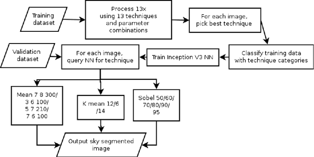
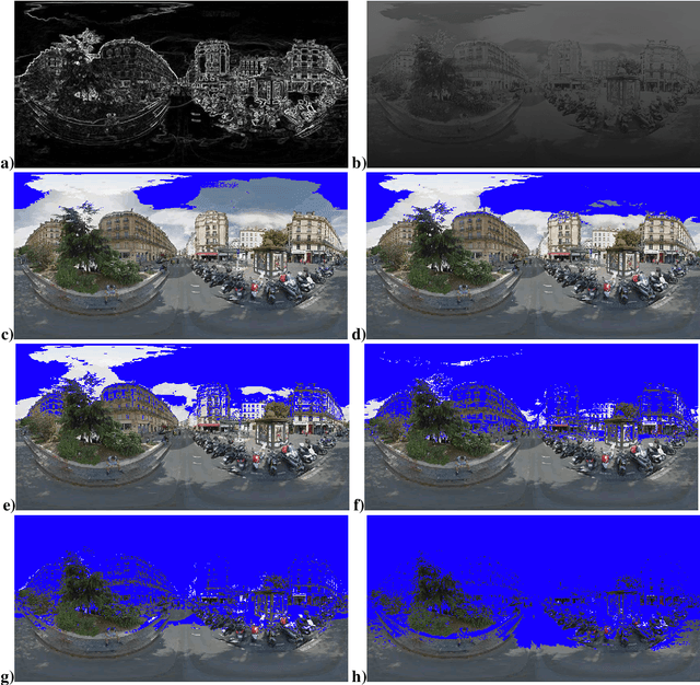
Abstract:Computer vision techniques allow automated detection of sky pixels in outdoor imagery. Multiple applications exist for this information across a large number of research areas. In urban climate, sky detection is an important first step in gathering information about urban morphology and sky view factors. However, capturing accurate results remains challenging and becomes even more complex using imagery captured under a variety of lighting and weather conditions. To address this problem, we present a new sky pixel detection system demonstrated to produce accurate results using a wide range of outdoor imagery types. Images are processed using a selection of mean-shift segmentation, K-means clustering, and Sobel filters to mark sky pixels in the scene. The algorithm for a specific image is chosen by a convolutional neural network, trained with 25,000 images from the Skyfinder data set, reaching 82% accuracy with the top three classes. This selection step allows the sky marking to follow an adaptive process and to use different techniques and parameters to best suit a particular image. An evaluation of fourteen different techniques and parameter sets shows that no single technique can perform with high accuracy across varied Skyfinder and Google Street View data sets. However, by using our adaptive process, large increases in accuracy are observed. The resulting system is shown to perform better than other published techniques.
 Add to Chrome
 Add to Firefox
 Add to Edge