Anne Meyer
Algorithmic Prompt-Augmentation for Efficient LLM-Based Heuristic Design for A* Search
Jan 27, 2026Abstract:Heuristic functions are essential to the performance of tree search algorithms such as A*, where their accuracy and efficiency directly impact search outcomes. Traditionally, such heuristics are handcrafted, requiring significant expertise. Recent advances in large language models (LLMs) and evolutionary frameworks have opened the door to automating heuristic design. In this paper, we extend the Evolution of Heuristics (EoH) framework to investigate the automated generation of guiding heuristics for A* search. We introduce a novel domain-agnostic prompt augmentation strategy that includes the A* code into the prompt to leverage in-context learning, named Algorithmic - Contextual EoH (A-CEoH). To evaluate the effectiveness of A-CeoH, we study two problem domains: the Unit-Load Pre-Marshalling Problem (UPMP), a niche problem from warehouse logistics, and the classical sliding puzzle problem (SPP). Our computational experiments show that A-CEoH can significantly improve the quality of the generated heuristics and even outperform expert-designed heuristics.
From Mice to Trains: Amortized Bayesian Inference on Graph Data
Jan 05, 2026Abstract:Graphs arise across diverse domains, from biology and chemistry to social and information networks, as well as in transportation and logistics. Inference on graph-structured data requires methods that are permutation-invariant, scalable across varying sizes and sparsities, and capable of capturing complex long-range dependencies, making posterior estimation on graph parameters particularly challenging. Amortized Bayesian Inference (ABI) is a simulation-based framework that employs generative neural networks to enable fast, likelihood-free posterior inference. We adapt ABI to graph data to address these challenges to perform inference on node-, edge-, and graph-level parameters. Our approach couples permutation-invariant graph encoders with flexible neural posterior estimators in a two-module pipeline: a summary network maps attributed graphs to fixed-length representations, and an inference network approximates the posterior over parameters. In this setting, several neural architectures can serve as the summary network. In this work we evaluate multiple architectures and assess their performance on controlled synthetic settings and two real-world domains - biology and logistics - in terms of recovery and calibration.
Reinforcement Learning for AMR Charging Decisions: The Impact of Reward and Action Space Design
May 16, 2025Abstract:We propose a novel reinforcement learning (RL) design to optimize the charging strategy for autonomous mobile robots in large-scale block stacking warehouses. RL design involves a wide array of choices that can mostly only be evaluated through lengthy experimentation. Our study focuses on how different reward and action space configurations, ranging from flexible setups to more guided, domain-informed design configurations, affect the agent performance. Using heuristic charging strategies as a baseline, we demonstrate the superiority of flexible, RL-based approaches in terms of service times. Furthermore, our findings highlight a trade-off: While more open-ended designs are able to discover well-performing strategies on their own, they may require longer convergence times and are less stable, whereas guided configurations lead to a more stable learning process but display a more limited generalization potential. Our contributions are threefold. First, we extend SLAPStack, an open-source, RL-compatible simulation-framework to accommodate charging strategies. Second, we introduce a novel RL design for tackling the charging strategy problem. Finally, we introduce several novel adaptive baseline heuristics and reproducibly evaluate the design using a Proximal Policy Optimization agent and varying different design configurations, with a focus on reward.
Leveraging Large Language Models to Develop Heuristics for Emerging Optimization Problems
Mar 05, 2025Abstract:Combinatorial optimization problems often rely on heuristic algorithms to generate efficient solutions. However, the manual design of heuristics is resource-intensive and constrained by the designer's expertise. Recent advances in artificial intelligence, particularly large language models (LLMs), have demonstrated the potential to automate heuristic generation through evolutionary frameworks. Recent works focus only on well-known combinatorial optimization problems like the traveling salesman problem and online bin packing problem when designing constructive heuristics. This study investigates whether LLMs can effectively generate heuristics for niche, not yet broadly researched optimization problems, using the unit-load pre-marshalling problem as an example case. We propose the Contextual Evolution of Heuristics (CEoH) framework, an extension of the Evolution of Heuristics (EoH) framework, which incorporates problem-specific descriptions to enhance in-context learning during heuristic generation. Through computational experiments, we evaluate CEoH and EoH and compare the results. Results indicate that CEoH enables smaller LLMs to generate high-quality heuristics more consistently and even outperform larger models. Larger models demonstrate robust performance with or without contextualized prompts. The generated heuristics exhibit scalability to diverse instance configurations.
Mission planning for emergency rapid mapping with drones
Mar 02, 2022
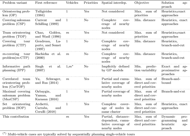
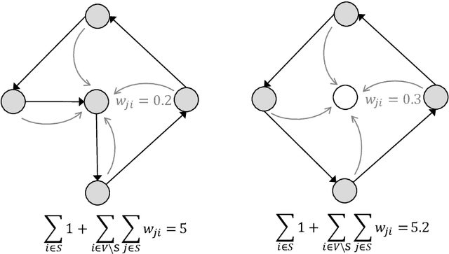

Abstract:We introduce a mission planning concept for routing unmanned aerial vehicles (UAVs) through a set of sampling locations in the immediate aftermath of an incident such as a fire or chemical accident. Using interpolation methods that account for the spatial interdependencies inherent in the surveyed phenomenon, these samples allow predicting the distribution of hazardous substances across the affected area. We define the generalized correlated team orienteering problem (GCorTOP) for selecting {informative} samples considering spatial correlations between observed and unobserved locations as well as priorities in the surveyed area. To quickly provide high-quality solutions in time-sensitive situations, we propose a two-phase multi-start adaptive large neighborhood search (2MLS). We show the competitiveness of the solution approach using benchmark instances for the team orienteering problem and investigate the performance of the proposed models and solution approach in an extensive study based on newly introduced benchmark instances for the mission planning problem.
Towards Standardizing Reinforcement Learning Approaches for Stochastic Production Scheduling
Apr 16, 2021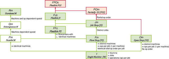
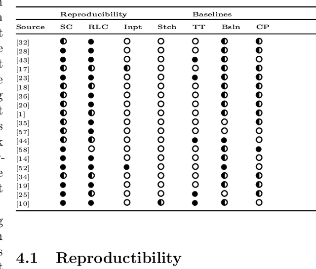
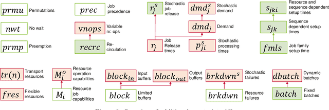
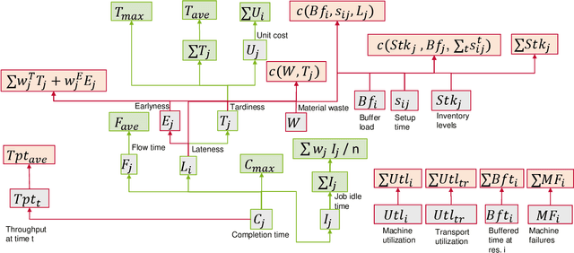
Abstract:Recent years have seen a rise in interest in terms of using machine learning, particularly reinforcement learning (RL), for production scheduling problems of varying degrees of complexity. The general approach is to break down the scheduling problem into a Markov Decision Process (MDP), whereupon a simulation implementing the MDP is used to train an RL agent. Since existing studies rely on (sometimes) complex simulations for which the code is unavailable, the experiments presented are hard, or, in the case of stochastic environments, impossible to reproduce accurately. Furthermore, there is a vast array of RL designs to choose from. To make RL methods widely applicable in production scheduling and work out their strength for the industry, the standardization of model descriptions - both production setup and RL design - and validation scheme are a prerequisite. Our contribution is threefold: First, we standardize the description of production setups used in RL studies based on established nomenclature. Secondly, we classify RL design choices from existing publications. Lastly, we propose recommendations for a validation scheme focusing on reproducibility and sufficient benchmarking.
Travel Time Prediction using Tree-Based Ensembles
May 28, 2020
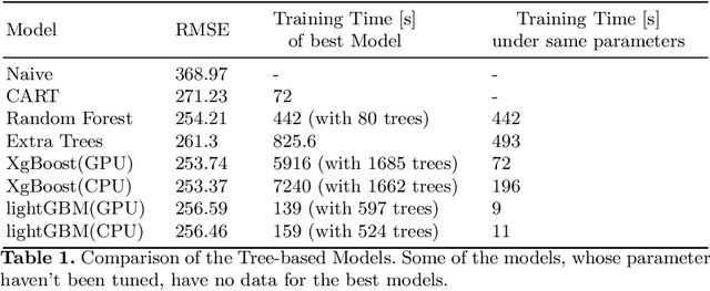


Abstract:In this paper, we consider the task of predicting travel times between two arbitrary points in an urban scenario. We view this problem from two temporal perspectives: long-term forecasting with a horizon of several days and short-term forecasting with a horizon of one hour. Both of these perspectives are relevant for planning tasks in the context of urban mobility and transportation services. We utilize tree-based ensemble methods that we train and evaluate on a dataset of taxi trip records from New York City. Through extensive data analysis, we identify relevant temporal and spatial features. We also engineer additional features based on weather and routing data. The latter is obtained via a routing solver operating on the road network. The computational results show that the addition of this routing data can be beneficial to the model performance. Moreover, employing different models for short and long-term prediction is useful as short-term models are better suited to mirror current traffic conditions. In fact, we show that accurate short-term predictions may be obtained with only little training data.
 Add to Chrome
 Add to Firefox
 Add to Edge