An Zhuo
MONOPOLY: Learning to Price Public Facilities for Revaluing Private Properties with Large-Scale Urban Data
Nov 27, 2024Abstract:The value assessment of private properties is an attractive but challenging task which is widely concerned by a majority of people around the world. A prolonged topic among us is ``\textit{how much is my house worth?}''. To answer this question, most experienced agencies would like to price a property given the factors of its attributes as well as the demographics and the public facilities around it. However, no one knows the exact prices of these factors, especially the values of public facilities which may help assess private properties. In this paper, we introduce our newly launched project ``Monopoly'' (named after a classic board game) in which we propose a distributed approach for revaluing private properties by learning to price public facilities (such as hospitals etc.) with the large-scale urban data we have accumulated via Baidu Maps. To be specific, our method organizes many points of interest (POIs) into an undirected weighted graph and formulates multiple factors including the virtual prices of surrounding public facilities as adaptive variables to parallelly estimate the housing prices we know. Then the prices of both public facilities and private properties can be iteratively updated according to the loss of prediction until convergence. We have conducted extensive experiments with the large-scale urban data of several metropolises in China. Results show that our approach outperforms several mainstream methods with significant margins. Further insights from more in-depth discussions demonstrate that the ``Monopoly'' is an innovative application in the interdisciplinary field of business intelligence and urban computing, and it will be beneficial to tens of millions of our users for investments and to the governments for urban planning as well as taxation.
ERNIE-GeoL: A Geography-and-Language Pre-trained Model and its Applications in Baidu Maps
Apr 06, 2022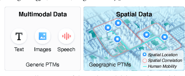

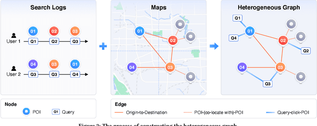

Abstract:Pre-trained models (PTMs) have become a fundamental backbone for downstream tasks in natural language processing and computer vision. Despite initial gains that were obtained by applying generic PTMs to geo-related tasks at Baidu Maps, a clear performance plateau over time was observed. One of the main reasons for this plateau is the lack of readily available geographic knowledge in generic PTMs. To address this problem, in this paper, we present ERNIE-GeoL, which is a geography-and-language pre-trained model designed and developed for improving the geo-related tasks at Baidu Maps. ERNIE-GeoL is elaborately designed to learn a universal representation of geography-language by pre-training on large-scale data generated from a heterogeneous graph that contains abundant geographic knowledge. Extensive quantitative and qualitative experiments conducted on large-scale real-world datasets demonstrate the superiority and effectiveness of ERNIE-GeoL. ERNIE-GeoL has already been deployed in production at Baidu Maps since April 2021, which significantly benefits the performance of a wide range of downstream tasks. This demonstrates that ERNIE-GeoL can serve as a fundamental backbone for geo-related tasks.
C-Watcher: A Framework for Early Detection of High-Risk Neighborhoods Ahead of COVID-19 Outbreak
Jan 27, 2021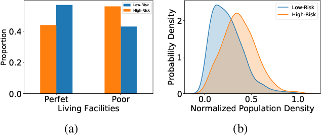

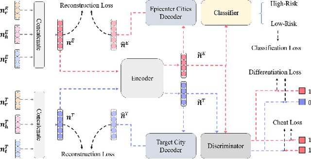
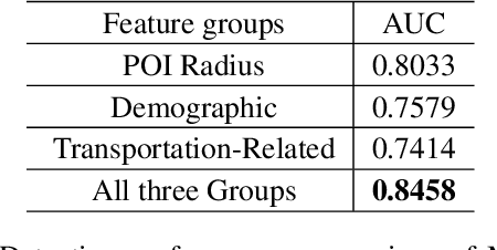
Abstract:The novel coronavirus disease (COVID-19) has crushed daily routines and is still rampaging through the world. Existing solution for nonpharmaceutical interventions usually needs to timely and precisely select a subset of residential urban areas for containment or even quarantine, where the spatial distribution of confirmed cases has been considered as a key criterion for the subset selection. While such containment measure has successfully stopped or slowed down the spread of COVID-19 in some countries, it is criticized for being inefficient or ineffective, as the statistics of confirmed cases are usually time-delayed and coarse-grained. To tackle the issues, we propose C-Watcher, a novel data-driven framework that aims at screening every neighborhood in a target city and predicting infection risks, prior to the spread of COVID-19 from epicenters to the city. In terms of design, C-Watcher collects large-scale long-term human mobility data from Baidu Maps, then characterizes every residential neighborhood in the city using a set of features based on urban mobility patterns. Furthermore, to transfer the firsthand knowledge (witted in epicenters) to the target city before local outbreaks, we adopt a novel adversarial encoder framework to learn "city-invariant" representations from the mobility-related features for precise early detection of high-risk neighborhoods, even before any confirmed cases known, in the target city. We carried out extensive experiments on C-Watcher using the real-data records in the early stage of COVID-19 outbreaks, where the results demonstrate the efficiency and effectiveness of C-Watcher for early detection of high-risk neighborhoods from a large number of cities.
 Add to Chrome
 Add to Firefox
 Add to Edge